Property Record
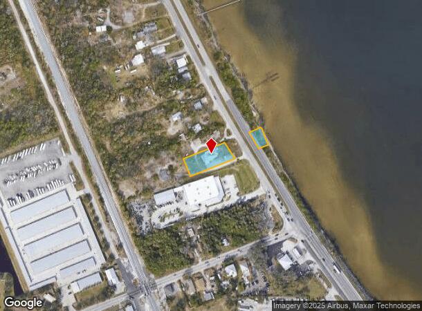
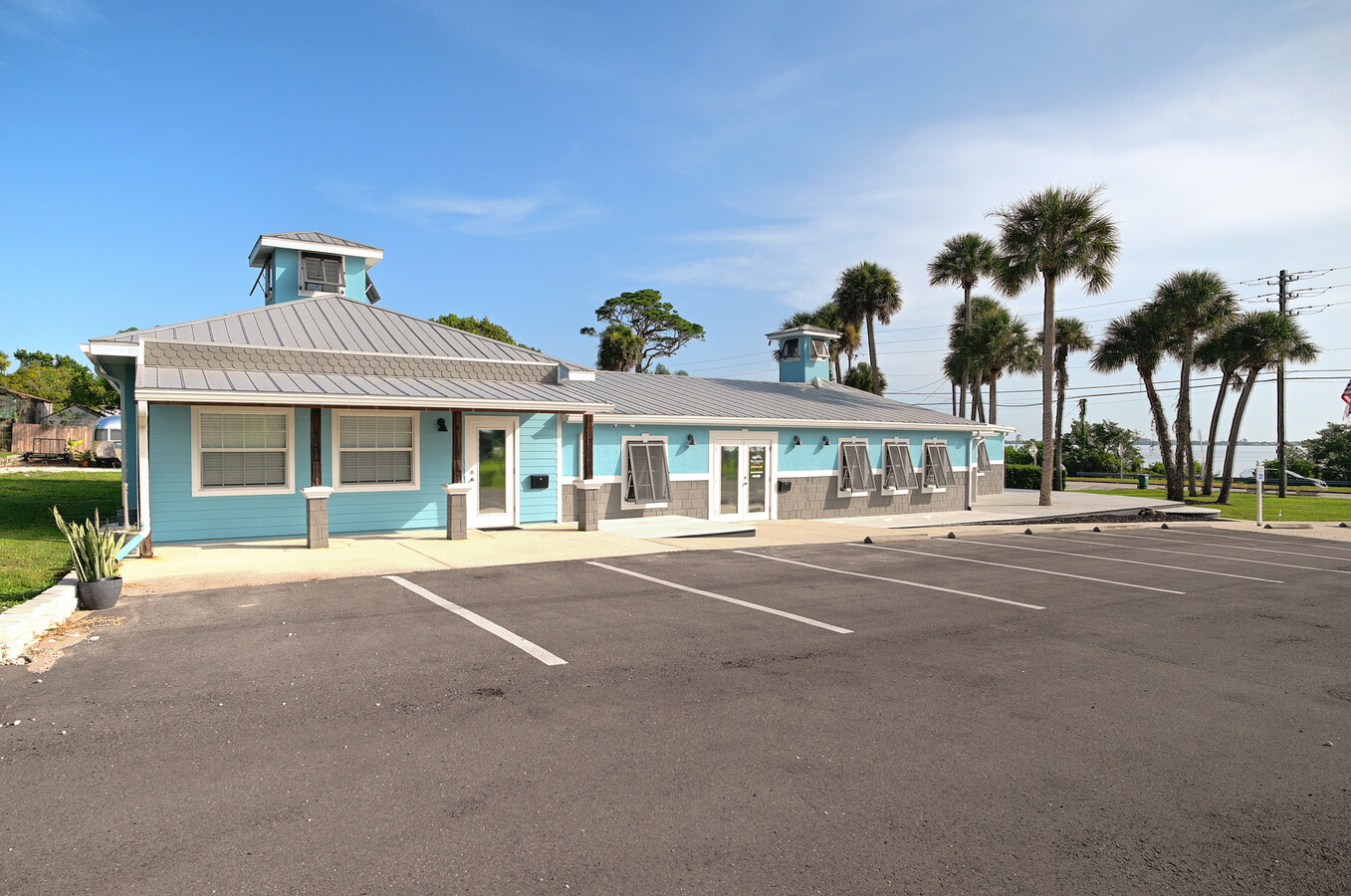
1280 S Us Highway 1, Malabar, FL 32950


NEARBY LISTINGS FOR SALE OR LEASE
Property Detail
1280 S Us Highway 1
28-38-31-00-00262.0-0000.00
PART OF LOT 2 & PT OF SE 1/4 OF NW 1/4 & PT OF NE 1/4 OF SW 1/4 S OF DB 295 PG 502 & N OF DB 287 PG 539 AS DES IN ORB 3212 PG 779 EXC US HWY 1 R/W PAR 263
Commercialnec
Brevard
X
Florida
12009C0614H
2
2023
0.61 AC
2023
Brevard County
065231
Orlando
3,533 SF
Palm Bay-Melbourne-Titusville, FL
DEMOGRAPHICS near 1280 S Us Highway 1
1 Mile
3 Mile
5 Mile
2024 Total Population
1,975
19,197
64,210
2029 Population
2,154
21,104
70,851
Pop Growth 2024-2029
+ 9.06%
+ 9.93%
+ 10.34%
Average Age
45
48
46
2024 Total Households
896
8,319
28,114
HH Growth 2024-2029
+ 8.82%
+ 9.91%
+ 10.20%
Median Household Inc
$57,465
$60,592
$51,822
Avg Household Size
2.20
2.20
2.20
2024 Avg HH Vehicles
2.00
2.00
2.00
Median Home Value
$237,037
$280,743
$236,155
Median Year Built
1976
1983
1985
Nearby Places
- Restaurants
- Banks
- Shops
- Fitness
- Groceries
PUBLIC TRANSPORTATION
AIRPORT
Melbourne Orlando International
DRIVE
WALK
Distance
Melbourne Orlando International
20 min
9.7 mi
Freight Ports
Port Canaveral
DRIVE
WALK
Distance
Port Canaveral
58 min
46.0 mi
SALE & LEASE HISTORY
LISTING DATE
SALE/LEASE

May 17, 2024
For Lease
Aug 17, 2023
For Sale
Apr 19, 2022
For Sale
Nearby Properties
Address
Land Use
TOTAL SIZE
Lot Size
Zoning
Address
Land Use
TOTAL SIZE
Lot Size
Zoning
1,695,838 SF
106.06 AC
Address
Land Use
TOTAL SIZE
Lot Size
Zoning
284,024 SF
16 AC
IU
Address
Land Use
TOTAL SIZE
Lot Size
Zoning
326,454 SF
14.20 AC
RM20
Address
Land Use
TOTAL SIZE
Lot Size
Zoning
39.75 AC
GML
Address
Land Use
TOTAL SIZE
Lot Size
Zoning
2,366 SF
32.43 AC
SR
Address
Land Use
TOTAL SIZE
Lot Size
Zoning
4,000 SF
12.20 AC
IU
Address
Land Use
TOTAL SIZE
Lot Size
Zoning
1,380 SF
21.87 AC
IU
Address
Land Use
TOTAL SIZE
Lot Size
Zoning
762 SF
49.89 AC
GML
Address
Land Use
TOTAL SIZE
Lot Size
Zoning
135,917 SF
2.92 AC
HC
Address
Land Use
TOTAL SIZE
Lot Size
Zoning
35.96 AC
GML
Address
Land Use
TOTAL SIZE
Lot Size
Zoning
352,735 SF
130.85 AC
Address
Land Use
TOTAL SIZE
Lot Size
Zoning
222,925 SF
12.75 AC
PUD
Address
Land Use
TOTAL SIZE
Lot Size
Zoning
76,534 SF
4.33 AC
HC
Address
Land Use
TOTAL SIZE
Lot Size
Zoning
202,908 SF
34.94 AC
LI
Address
Land Use
TOTAL SIZE
Lot Size
Zoning
48,492 SF
17.45 AC
OI
Address
Land Use
TOTAL SIZE
Lot Size
Zoning
6.48 AC
GML
Address
Land Use
TOTAL SIZE
Lot Size
Zoning
97,728 SF
12.77 AC
IU
Address
Land Use
TOTAL SIZE
Lot Size
Zoning
109,650 SF
10.32 AC
CG
Address
Land Use
TOTAL SIZE
Lot Size
Zoning
5.83 AC
GML
Address
Land Use
TOTAL SIZE
Lot Size
Zoning
31.07 AC
GML
Address
Land Use
TOTAL SIZE
Lot Size
Zoning
80,425 SF
12.78 AC
HC
Address
Land Use
TOTAL SIZE
Lot Size
Zoning
1,535 SF
3.85 AC
GML
Address
Land Use
TOTAL SIZE
Lot Size
Zoning
4.23 AC
GML
Address
Land Use
TOTAL SIZE
Lot Size
Zoning
12.84 AC
GML
Address
Land Use
TOTAL SIZE
Lot Size
Zoning
14.28 AC
SR
Address
Land Use
TOTAL SIZE
Lot Size
Zoning
78,357 SF
8.47 AC
BU1
Address
Land Use
TOTAL SIZE
Lot Size
Zoning
93,240 SF
4.67 AC
LI
Address
Land Use
TOTAL SIZE
Lot Size
Zoning
4.02 AC
GML
Address
Land Use
TOTAL SIZE
Lot Size
Zoning
27,837 SF
8.24 AC
IN(L)
Address
Land Use
TOTAL SIZE
Lot Size
Zoning
40,192 SF
6.92 AC
HC
The World's #1 Commercial Real Estate Marketplace
Connect with us
© 2025 CoStar Group
The information above has been obtained from sources believed reliable. While we do not doubt its accuracy we have not verified it and make no guarantee, warranty or representation about it. It is your responsibility to independently confirm its accuracy and completeness. Any projections, opinions, assumptions, or estimates used are for example only and do not represent the current or future performance of the property. The value of this transaction to you depends on tax and other factors which should be evaluated by your tax, financial, and legal advisors. You and your advisors should conduct a careful, independent investigation of the property to determine to your satisfaction the suitability of the property for your needs.