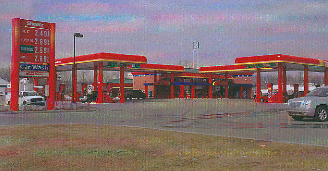
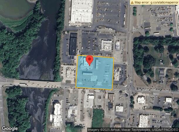
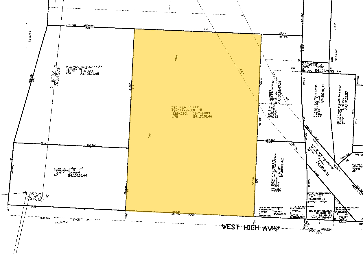
Property Record
1281 W High Ave, New Philadelphia, OH 44663
NEARBY LISTINGS FOR SALE OR LEASE
-
-
No Photo
-
-
-
View all New Philadelphia listings for sale on LoopNet.com
Property Detail
1281 W High Ave
4307779000
2 8 2 AT DAM 2.7509A
Servicestation
Tuscarawas
X
Ohio
39157C0255D
2.75 AC
2023
Ohio North Area
2023
Other Market Areas
020801
New Philadelphia-Dover, OH
4,917 SF
DEMOGRAPHICS near 1281 W High Ave
1 Mile
3 Mile
5 Mile
2024 Total Population
4,334
31,038
39,740
2029 Population
4,327
30,887
39,495
Pop Growth 2024-2029
(0.16%)
(0.49%)
(0.62%)
Average Age
40
42
42
2024 Total Households
1,845
12,957
16,492
HH Growth 2024-2029
(0.33%)
(0.57%)
(0.70%)
Median Household Inc
$45,610
$52,017
$56,259
Avg Household Size
2.20
2.30
2.30
2024 Avg HH Vehicles
2.00
2.00
2.00
Median Home Value
$131,485
$156,956
$167,097
Median Year Built
1957
1962
1966
Nearby Places
- Restaurants
- Banks
- Shops
- Fitness
- Groceries
PUBLIC TRANSPORTATION
AIRPORT
Akron-Canton Regional
DRIVE
WALK
Distance
Akron-Canton Regional
39 min
34.3 mi
Freight Ports
Port of Toledo
DRIVE
WALK
Distance
Port of Toledo
210 min
181.5 mi
Nearby Properties
Address
Land Use
TOTAL SIZE
Lot Size
Zoning
Address
Land Use
TOTAL SIZE
Lot Size
Zoning
47,575 SF
3.59 AC
Address
Land Use
TOTAL SIZE
Lot Size
Zoning
77,274 SF
8.56 AC
Address
Land Use
TOTAL SIZE
Lot Size
Zoning
226,421 SF
39.33 AC
Address
Land Use
TOTAL SIZE
Lot Size
Zoning
2,120 SF
11.82 AC
Address
Land Use
TOTAL SIZE
Lot Size
Zoning
50,519 SF
28.36 AC
Address
Land Use
TOTAL SIZE
Lot Size
Zoning
173,870 SF
41.49 AC
Address
Land Use
TOTAL SIZE
Lot Size
Zoning
116,148 SF
22.57 AC
Address
Land Use
TOTAL SIZE
Lot Size
Zoning
48,441 SF
1.60 AC
Address
Land Use
TOTAL SIZE
Lot Size
Zoning
46,548 SF
8 AC
Address
Land Use
TOTAL SIZE
Lot Size
Zoning
30,257 SF
3.04 AC
Address
Land Use
TOTAL SIZE
Lot Size
Zoning
19,001 SF
0.80 AC
Address
Land Use
TOTAL SIZE
Lot Size
Zoning
20,612 SF
1.61 AC
Address
Land Use
TOTAL SIZE
Lot Size
Zoning
36,060 SF
92.75 AC
Address
Land Use
TOTAL SIZE
Lot Size
Zoning
13,989 SF
2.04 AC
Address
Land Use
TOTAL SIZE
Lot Size
Zoning
6.57 AC
Address
Land Use
TOTAL SIZE
Lot Size
Zoning
33,189 SF
6.31 AC
Address
Land Use
TOTAL SIZE
Lot Size
Zoning
32,928 SF
1.12 AC
Address
Land Use
TOTAL SIZE
Lot Size
Zoning
50,699 SF
10.34 AC
Address
Land Use
TOTAL SIZE
Lot Size
Zoning
14,742 SF
6.14 AC
Address
Land Use
TOTAL SIZE
Lot Size
Zoning
64,338 SF
7.21 AC
Address
Land Use
TOTAL SIZE
Lot Size
Zoning
2 SF
12.34 AC
Address
Land Use
TOTAL SIZE
Lot Size
Zoning
80,676 SF
12.28 AC
Address
Land Use
TOTAL SIZE
Lot Size
Zoning
20,712 SF
7.11 AC
Address
Land Use
TOTAL SIZE
Lot Size
Zoning
14,078 SF
2.30 AC
Address
Land Use
TOTAL SIZE
Lot Size
Zoning
Address
Land Use
TOTAL SIZE
Lot Size
Zoning
13,861 SF
1.64 AC
Address
Land Use
TOTAL SIZE
Lot Size
Zoning
1 SF
21.63 AC
Address
Land Use
TOTAL SIZE
Lot Size
Zoning
96,882 SF
43.42 AC
Address
Land Use
TOTAL SIZE
Lot Size
Zoning
33,685 SF
13.89 AC
Address
Land Use
TOTAL SIZE
Lot Size
Zoning
The World's #1 Commercial Real Estate Marketplace
Connect with us
© 2025 CoStar Group
The information above has been obtained from sources believed reliable. While we do not doubt its accuracy we have not verified it and make no guarantee, warranty or representation about it. It is your responsibility to independently confirm its accuracy and completeness. Any projections, opinions, assumptions, or estimates used are for example only and do not represent the current or future performance of the property. The value of this transaction to you depends on tax and other factors which should be evaluated by your tax, financial, and legal advisors. You and your advisors should conduct a careful, independent investigation of the property to determine to your satisfaction the suitability of the property for your needs.