Property Record
12811 75Th St, Bristol, WI 53104
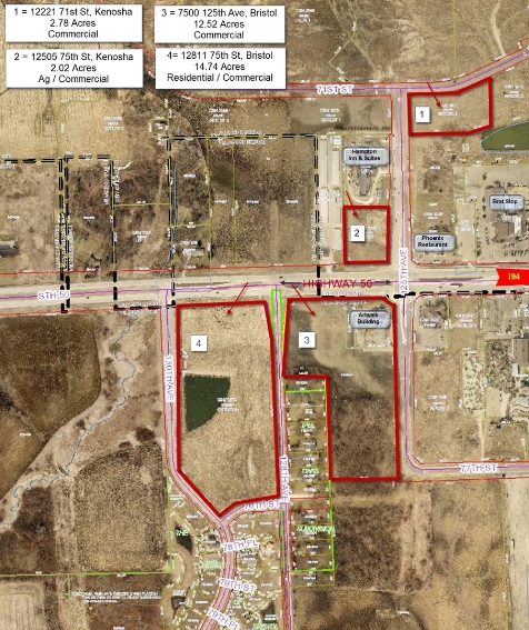


This Property Is For Sale
NEARBY LISTINGS FOR SALE OR LEASE
Property Detail
12811 75Th St
Chicago-Naperville-Elgin, IL-IN-WI
Csm# 2473
37-4-121-122-0110
OUTLOT 1 CSM #2473 DOC #1437056 PT SECS 11 & 12 T 1 R 21 14.74 AC EXC ROW AS IN CSM #2650 (2006 COMB 35-4-121-122-0100, -122-
Commercialnec
Kenosha
X
Wisconsin
55059C0179D
1
2023
14.74 AC
2023
Kenosha East
002700
Chicago
1,500 SF
DEMOGRAPHICS near 12811 75Th St
1 Mile
3 Mile
5 Mile
2024 Total Population
1,145
16,392
33,870
2029 Population
1,173
16,469
33,882
Pop Growth 2024-2029
+ 2.45%
+ 0.47%
+ 0.04%
Average Age
40
39
40
2024 Total Households
433
6,224
13,031
HH Growth 2024-2029
+ 2.54%
+ 0.51%
+ 0.02%
Median Household Inc
$121,874
$93,688
$85,415
Avg Household Size
2.60
2.60
2.50
2024 Avg HH Vehicles
2.00
2.00
2.00
Median Home Value
$448,351
$297,671
$280,929
Median Year Built
2004
2000
1993
Nearby Places
- Restaurants
- Banks
- Shops
- Fitness
- Groceries
PUBLIC TRANSPORTATION
COMMUTER RAIL
Kenosha Station (Union Pacific North Line - Northeast Illinois Regional Commuter Railroad (Metra))
DRIVE
WALK
Distance
Kenosha Station (Union Pacific North Line - Northeast Illinois Regional Commuter Railroad (Metra))
16 min
8.7 mi
AIRPORT
General Mitchell International
DRIVE
WALK
Distance
General Mitchell International
35 min
29.1 mi
Freight Ports
Port Milwaukee
DRIVE
WALK
Distance
Port Milwaukee
40 min
33.0 mi
Nearby Properties
Address
Land Use
TOTAL SIZE
Lot Size
Zoning
Address
Land Use
TOTAL SIZE
Lot Size
Zoning
159,194 SF
136.60 AC
Address
Land Use
TOTAL SIZE
Lot Size
Zoning
51,119 SF
63.71 AC
Address
Land Use
TOTAL SIZE
Lot Size
Zoning
1,015,740 SF
113.58 AC
C2
Address
Land Use
TOTAL SIZE
Lot Size
Zoning
68.19 AC
Address
Land Use
TOTAL SIZE
Lot Size
Zoning
67.63 AC
FW
Address
Land Use
TOTAL SIZE
Lot Size
Zoning
12,876 SF
30.13 AC
Address
Land Use
TOTAL SIZE
Lot Size
Zoning
77.22 AC
Address
Land Use
TOTAL SIZE
Lot Size
Zoning
481,854 SF
84.10 AC
FW
Address
Land Use
TOTAL SIZE
Lot Size
Zoning
48.22 AC
Address
Land Use
TOTAL SIZE
Lot Size
Zoning
1,467 SF
50.67 AC
Address
Land Use
TOTAL SIZE
Lot Size
Zoning
16.01 AC
Address
Land Use
TOTAL SIZE
Lot Size
Zoning
27.77 AC
Address
Land Use
TOTAL SIZE
Lot Size
Zoning
418,036 SF
25.33 AC
Address
Land Use
TOTAL SIZE
Lot Size
Zoning
447,200 SF
23.50 AC
Address
Land Use
TOTAL SIZE
Lot Size
Zoning
626,520 SF
35.19 AC
M2
Address
Land Use
TOTAL SIZE
Lot Size
Zoning
13.10 AC
Address
Land Use
TOTAL SIZE
Lot Size
Zoning
20.33 AC
M2
Address
Land Use
TOTAL SIZE
Lot Size
Zoning
31,809 SF
11.36 AC
BASE
Address
Land Use
TOTAL SIZE
Lot Size
Zoning
50,145 SF
12.76 AC
Address
Land Use
TOTAL SIZE
Lot Size
Zoning
21.62 AC
Address
Land Use
TOTAL SIZE
Lot Size
Zoning
314,505 SF
19.30 AC
Address
Land Use
TOTAL SIZE
Lot Size
Zoning
55,140 SF
21 AC
FW
Address
Land Use
TOTAL SIZE
Lot Size
Zoning
48,284 SF
4.99 AC
Address
Land Use
TOTAL SIZE
Lot Size
Zoning
31.07 AC
Address
Land Use
TOTAL SIZE
Lot Size
Zoning
163.46 AC
Address
Land Use
TOTAL SIZE
Lot Size
Zoning
148,330 SF
17.55 AC
Address
Land Use
TOTAL SIZE
Lot Size
Zoning
247,185 SF
18.21 AC
B2
Address
Land Use
TOTAL SIZE
Lot Size
Zoning
14.46 AC
M2
Address
Land Use
TOTAL SIZE
Lot Size
Zoning
69,568 SF
37.52 AC
Address
Land Use
TOTAL SIZE
Lot Size
Zoning
17,578 SF
3.98 AC
The World's #1 Commercial Real Estate Marketplace
Connect with us
© 2025 CoStar Group
The information above has been obtained from sources believed reliable. While we do not doubt its accuracy we have not verified it and make no guarantee, warranty or representation about it. It is your responsibility to independently confirm its accuracy and completeness. Any projections, opinions, assumptions, or estimates used are for example only and do not represent the current or future performance of the property. The value of this transaction to you depends on tax and other factors which should be evaluated by your tax, financial, and legal advisors. You and your advisors should conduct a careful, independent investigation of the property to determine to your satisfaction the suitability of the property for your needs.