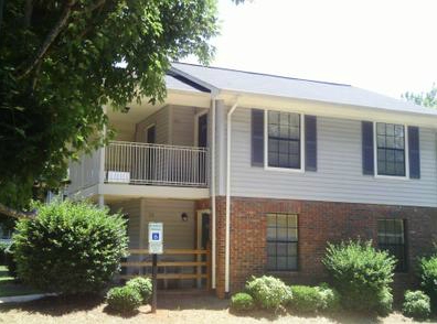
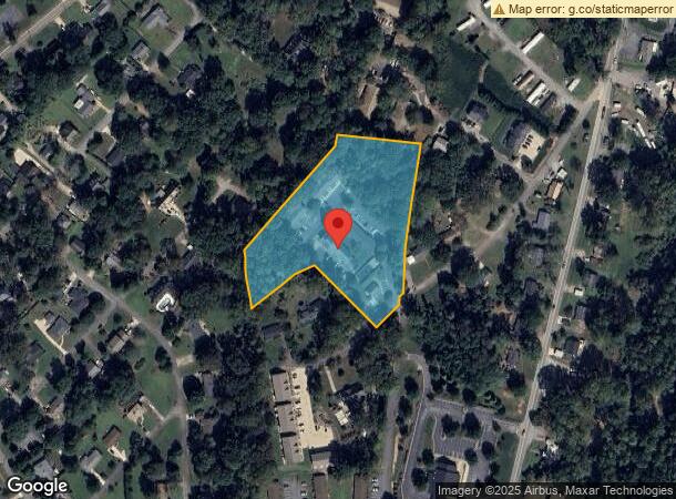
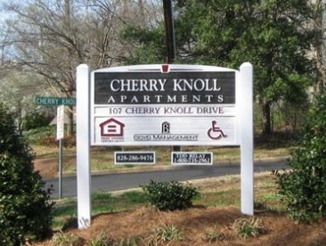
Property Record
107 Cherry Knoll Dr, Rutherfordton, NC 28139
NEARBY LISTINGS FOR SALE OR LEASE
-
-
View all Rutherfordton listings for sale on LoopNet.com
Property Detail
107 Cherry Knoll Dr
1600147
GPIN:1519077819750000; GILBERT
Officebuilding
Rutherford
X
North Carolina
3710151900J
3.86 AC
2023
North Carolina West/Cherokee Area
2024
Other Market Areas
960503
Forest City, NC
465 SF
DEMOGRAPHICS near 107 Cherry Knoll Dr
1 Mile
3 Mile
5 Mile
2024 Total Population
2,769
12,268
20,831
2029 Population
2,850
12,581
21,260
Pop Growth 2024-2029
+ 2.93%
+ 2.55%
+ 2.06%
Average Age
44
43
43
2024 Total Households
1,199
5,029
8,545
HH Growth 2024-2029
+ 2.84%
+ 2.47%
+ 1.94%
Median Household Inc
$32,040
$37,666
$40,670
Avg Household Size
2.20
2.30
2.30
2024 Avg HH Vehicles
2.00
2.00
2.00
Median Home Value
$186,798
$159,711
$160,701
Median Year Built
1981
1974
1976
Nearby Places
- Restaurants
- Banks
- Shops
- Fitness
- Groceries
Nearby Properties
Address
Land Use
TOTAL SIZE
Lot Size
Zoning
Address
Land Use
TOTAL SIZE
Lot Size
Zoning
168,615 SF
27.34 AC
CIV
Address
Land Use
TOTAL SIZE
Lot Size
Zoning
29,884 SF
54.60 AC
Address
Land Use
TOTAL SIZE
Lot Size
Zoning
141,217 SF
27.03 AC
Address
Land Use
TOTAL SIZE
Lot Size
Zoning
87,123 SF
1.98 AC
Address
Land Use
TOTAL SIZE
Lot Size
Zoning
61,023 SF
7.64 AC
R6
Address
Land Use
TOTAL SIZE
Lot Size
Zoning
1,408 SF
6.95 AC
R20
Address
Land Use
TOTAL SIZE
Lot Size
Zoning
5,428 SF
14.29 AC
Address
Land Use
TOTAL SIZE
Lot Size
Zoning
2,026 SF
8.71 AC
R6
Address
Land Use
TOTAL SIZE
Lot Size
Zoning
6,592 SF
18.30 AC
CIV
Address
Land Use
TOTAL SIZE
Lot Size
Zoning
95,267 SF
8.40 AC
GC
Address
Land Use
TOTAL SIZE
Lot Size
Zoning
16,074 SF
101.60 AC
Address
Land Use
TOTAL SIZE
Lot Size
Zoning
7,424 SF
6.39 AC
IND
Address
Land Use
TOTAL SIZE
Lot Size
Zoning
53,790 SF
6.37 AC
R6
Address
Land Use
TOTAL SIZE
Lot Size
Zoning
6,448 SF
3.30 AC
GC
Address
Land Use
TOTAL SIZE
Lot Size
Zoning
6,000 SF
15.30 AC
Address
Land Use
TOTAL SIZE
Lot Size
Zoning
6,988 SF
1.51 AC
R6
Address
Land Use
TOTAL SIZE
Lot Size
Zoning
10,366 SF
1.22 AC
CIV
Address
Land Use
TOTAL SIZE
Lot Size
Zoning
19,530 SF
1.50 AC
CIV
Address
Land Use
TOTAL SIZE
Lot Size
Zoning
34,861 SF
4.38 AC
CIV
Address
Land Use
TOTAL SIZE
Lot Size
Zoning
93,600 SF
45.11 AC
HCI
Address
Land Use
TOTAL SIZE
Lot Size
Zoning
17,622 SF
5 AC
RMST
Address
Land Use
TOTAL SIZE
Lot Size
Zoning
11,502 SF
0.64 AC
CIV
Address
Land Use
TOTAL SIZE
Lot Size
Zoning
42,360 SF
CIV
Address
Land Use
TOTAL SIZE
Lot Size
Zoning
1,200 SF
6.13 AC
SFR-3
Address
Land Use
TOTAL SIZE
Lot Size
Zoning
755.18 AC
Address
Land Use
TOTAL SIZE
Lot Size
Zoning
68,755 SF
11.73 AC
IND
Address
Land Use
TOTAL SIZE
Lot Size
Zoning
9,811 SF
3.13 AC
Address
Land Use
TOTAL SIZE
Lot Size
Zoning
42,480 SF
3.90 AC
CIV
Address
Land Use
TOTAL SIZE
Lot Size
Zoning
27,402 SF
0.09 AC
C1
Address
Land Use
TOTAL SIZE
Lot Size
Zoning
120,800 SF
12.79 AC
HCI
The World's #1 Commercial Real Estate Marketplace
Connect with us
© 2025 CoStar Group
The information above has been obtained from sources believed reliable. While we do not doubt its accuracy we have not verified it and make no guarantee, warranty or representation about it. It is your responsibility to independently confirm its accuracy and completeness. Any projections, opinions, assumptions, or estimates used are for example only and do not represent the current or future performance of the property. The value of this transaction to you depends on tax and other factors which should be evaluated by your tax, financial, and legal advisors. You and your advisors should conduct a careful, independent investigation of the property to determine to your satisfaction the suitability of the property for your needs.