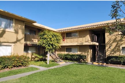
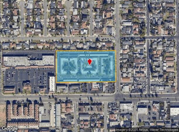
Property Record
12921 Dale St, Garden Grove, CA 92841

NEARBY LISTINGS FOR SALE OR LEASE
Property Detail
12921 Dale St
131-541-22
S TWP 4 RGE 11 SEC 36 SEC 36 T 4 R 11 SW1/4
Multifamilydwelling
Orange
X
California
06059C0138J
5.24 AC
2024
Garden Grove
2024
Orange County (California)
088106
Anaheim-Santa Ana-Irvine, CA
106,527 SF
DEMOGRAPHICS near 12921 Dale St
1 Mile
3 Mile
5 Mile
2024 Total Population
36,666
269,598
662,394
2029 Population
36,343
266,663
654,193
Pop Growth 2024-2029
(0.88%)
(1.09%)
(1.24%)
Average Age
40
41
40
2024 Total Households
10,665
77,698
195,509
HH Growth 2024-2029
(0.83%)
(1.21%)
(1.37%)
Median Household Inc
$70,888
$76,263
$81,984
Avg Household Size
3.30
3.30
3.20
2024 Avg HH Vehicles
2.00
2.00
2.00
Median Home Value
$619,641
$696,164
$714,832
Median Year Built
1971
1967
1968
Nearby Places
- Restaurants
- Banks
- Shops
- Fitness
- Groceries
PUBLIC TRANSPORTATION
COMMUTER RAIL
Anaheim (Pacific Surfliner - Amtrak)
DRIVE
WALK
Distance
Anaheim (Pacific Surfliner - Amtrak)
15 min
9.8 mi
Anaheim-Artic Metrolink Station (Metrolink Orange County Line - Metrolink Trains)
DRIVE
WALK
Distance
Anaheim-Artic Metrolink Station (Metrolink Orange County Line - Metrolink Trains)
15 min
10.0 mi
AIRPORT
John Wayne/Orange County
DRIVE
WALK
Distance
John Wayne/Orange County
18 min
11.8 mi
Long Beach (Daugherty Field)
DRIVE
WALK
Distance
Long Beach (Daugherty Field)
16 min
12.7 mi
Los Angeles International
DRIVE
WALK
Distance
Los Angeles International
40 min
31.5 mi
Freight Ports
Port of Long Beach
DRIVE
WALK
Distance
Port of Long Beach
21 min
12.2 mi
Nearby Properties
Address
Land Use
TOTAL SIZE
Lot Size
Zoning
Address
Land Use
TOTAL SIZE
Lot Size
Zoning
Address
Land Use
TOTAL SIZE
Lot Size
Zoning
Address
Land Use
TOTAL SIZE
Lot Size
Zoning
292,787 SF
4.95 AC
Address
Land Use
TOTAL SIZE
Lot Size
Zoning
22.31 AC
Address
Land Use
TOTAL SIZE
Lot Size
Zoning
35.40 AC
Address
Land Use
TOTAL SIZE
Lot Size
Zoning
4.86 AC
Address
Land Use
TOTAL SIZE
Lot Size
Zoning
Address
Land Use
TOTAL SIZE
Lot Size
Zoning
13.97 AC
Address
Land Use
TOTAL SIZE
Lot Size
Zoning
3.77 AC
Address
Land Use
TOTAL SIZE
Lot Size
Zoning
Address
Land Use
TOTAL SIZE
Lot Size
Zoning
26,960 SF
64.86 AC
Address
Land Use
TOTAL SIZE
Lot Size
Zoning
Address
Land Use
TOTAL SIZE
Lot Size
Zoning
188,602 SF
11.46 AC
Address
Land Use
TOTAL SIZE
Lot Size
Zoning
199,534 SF
12.89 AC
Address
Land Use
TOTAL SIZE
Lot Size
Zoning
Address
Land Use
TOTAL SIZE
Lot Size
Zoning
3.12 AC
Address
Land Use
TOTAL SIZE
Lot Size
Zoning
Address
Land Use
TOTAL SIZE
Lot Size
Zoning
2.55 AC
Address
Land Use
TOTAL SIZE
Lot Size
Zoning
928 SF
5.23 AC
Address
Land Use
TOTAL SIZE
Lot Size
Zoning
109,032 SF
5.24 AC
Address
Land Use
TOTAL SIZE
Lot Size
Zoning
Address
Land Use
TOTAL SIZE
Lot Size
Zoning
Address
Land Use
TOTAL SIZE
Lot Size
Zoning
6,032 SF
19.25 AC
Address
Land Use
TOTAL SIZE
Lot Size
Zoning
24.99 AC
Address
Land Use
TOTAL SIZE
Lot Size
Zoning
15.08 AC
Address
Land Use
TOTAL SIZE
Lot Size
Zoning
8.51 AC
Address
Land Use
TOTAL SIZE
Lot Size
Zoning
Address
Land Use
TOTAL SIZE
Lot Size
Zoning
29,749 SF
1.69 AC
Address
Land Use
TOTAL SIZE
Lot Size
Zoning
Address
Land Use
TOTAL SIZE
Lot Size
Zoning
The World's #1 Commercial Real Estate Marketplace
Connect with us
© 2025 CoStar Group
The information above has been obtained from sources believed reliable. While we do not doubt its accuracy we have not verified it and make no guarantee, warranty or representation about it. It is your responsibility to independently confirm its accuracy and completeness. Any projections, opinions, assumptions, or estimates used are for example only and do not represent the current or future performance of the property. The value of this transaction to you depends on tax and other factors which should be evaluated by your tax, financial, and legal advisors. You and your advisors should conduct a careful, independent investigation of the property to determine to your satisfaction the suitability of the property for your needs.