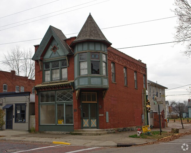
Property Record
130 Maple St, Marietta, OH 45750


NEARBY LISTINGS FOR SALE OR LEASE
Property Detail
130 Maple St
2400-08264-000
Harmar Village Square #90
Officebuilding
BLK 90 LOT 34 26.15 FT MA PLE ST X 50 FT GILMAN
AE
Washington
54107C0037D
Ohio
2024
34
2024
0.04 AC
020500
Other Market Areas
2,217 SF
Marietta, OH
DEMOGRAPHICS near 130 Maple St
1 Mile
3 Mile
5 Mile
2024 Total Population
7,148
19,910
30,687
2029 Population
7,076
19,761
30,454
Pop Growth 2024-2029
(1.01%)
(0.75%)
(0.76%)
Average Age
40
42
43
2024 Total Households
2,877
8,542
13,150
HH Growth 2024-2029
(0.90%)
(0.75%)
(0.76%)
Median Household Inc
$47,349
$48,022
$54,443
Avg Household Size
2.10
2.20
2.20
2024 Avg HH Vehicles
2.00
2.00
2.00
Median Home Value
$156,680
$156,040
$162,762
Median Year Built
1950
1962
1970
Nearby Places
Map Layers
Map Styles
 Street
 Aerial
- Restaurants
- Banks
- Shops
- Fitness
- Groceries
Nearby Properties
Address
Land Use
TOTAL SIZE
Lot Size
Zoning
Address
Land Use
TOTAL SIZE
Lot Size
Zoning
53,390 SF
0.22 AC
Address
Land Use
TOTAL SIZE
Lot Size
Zoning
106,780 SF
Address
Land Use
TOTAL SIZE
Lot Size
Zoning
6,888 SF
Address
Land Use
TOTAL SIZE
Lot Size
Zoning
Address
Land Use
TOTAL SIZE
Lot Size
Zoning
0.72 AC
Address
Land Use
TOTAL SIZE
Lot Size
Zoning
4.50 AC
Address
Land Use
TOTAL SIZE
Lot Size
Zoning
6,918 SF
3 AC
Address
Land Use
TOTAL SIZE
Lot Size
Zoning
Address
Land Use
TOTAL SIZE
Lot Size
Zoning
27,376 SF
0.82 AC
Address
Land Use
TOTAL SIZE
Lot Size
Zoning
38,160 SF
41.31 AC
Address
Land Use
TOTAL SIZE
Lot Size
Zoning
31.05 AC
Address
Land Use
TOTAL SIZE
Lot Size
Zoning
6,567 SF
5.05 AC
Address
Land Use
TOTAL SIZE
Lot Size
Zoning
5,390 SF
Address
Land Use
TOTAL SIZE
Lot Size
Zoning
1,680 SF
52.38 AC
Address
Land Use
TOTAL SIZE
Lot Size
Zoning
11.11 AC
Address
Land Use
TOTAL SIZE
Lot Size
Zoning
6,080 SF
2.28 AC
Address
Land Use
TOTAL SIZE
Lot Size
Zoning
8.34 AC
Address
Land Use
TOTAL SIZE
Lot Size
Zoning
3.34 AC
Address
Land Use
TOTAL SIZE
Lot Size
Zoning
1,845 SF
7.21 AC
Address
Land Use
TOTAL SIZE
Lot Size
Zoning
13,238 SF
0.82 AC
Address
Land Use
TOTAL SIZE
Lot Size
Zoning
11,528 SF
42.37 AC
Address
Land Use
TOTAL SIZE
Lot Size
Zoning
24,800 SF
0.32 AC
Address
Land Use
TOTAL SIZE
Lot Size
Zoning
6,020 SF
0.47 AC
Address
Land Use
TOTAL SIZE
Lot Size
Zoning
62,139 SF
12.10 AC
Address
Land Use
TOTAL SIZE
Lot Size
Zoning
53,121 SF
1.53 AC
Address
Land Use
TOTAL SIZE
Lot Size
Zoning
22,996 SF
2.70 AC
Address
Land Use
TOTAL SIZE
Lot Size
Zoning
Address
Land Use
TOTAL SIZE
Lot Size
Zoning
26,758 SF
3.81 AC
Address
Land Use
TOTAL SIZE
Lot Size
Zoning
10,028 SF
2.67 AC
Address
Land Use
TOTAL SIZE
Lot Size
Zoning
17,943 SF
3.70 AC
The World's #1 Commercial Real Estate Marketplace
Connect with us
© 2025 CoStar Group
The information above has been obtained from sources believed reliable. While we do not doubt its accuracy we have not verified it and make no guarantee, warranty or representation about it. It is your responsibility to independently confirm its accuracy and completeness. Any projections, opinions, assumptions, or estimates used are for example only and do not represent the current or future performance of the property. The value of this transaction to you depends on tax and other factors which should be evaluated by your tax, financial, and legal advisors. You and your advisors should conduct a careful, independent investigation of the property to determine to your satisfaction the suitability of the property for your needs.