Property Record
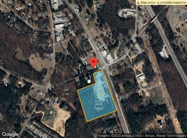
130 Neelys Creek Rd, Rock Hill, SC 29730

NEARBY LISTINGS FOR SALE OR LEASE
Property Detail
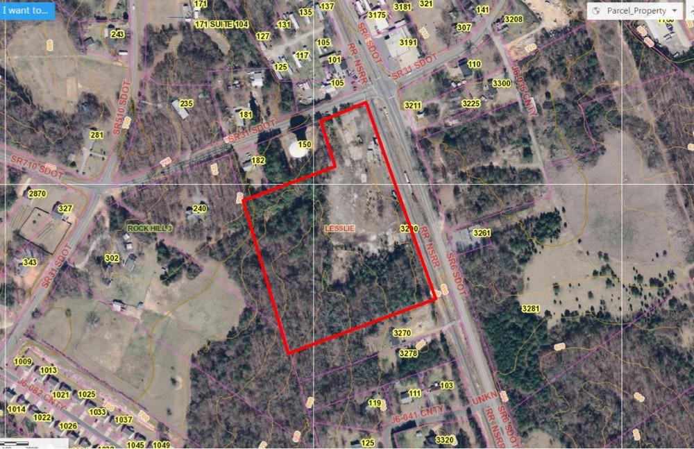
130 Neelys Creek Rd
Charlotte-Concord-Gastonia, NC-SC
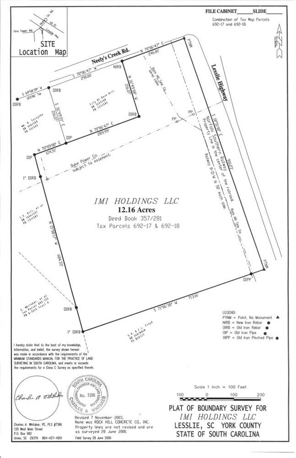
Plat Of Boundary Survey For Rock Hill Co
6920000017
HWY 31 (12.16 AC)
Industrialgeneral
York
X
South Carolina
45091C0339E
12.16 AC
2024
York County
2024
Charlotte
061205
DEMOGRAPHICS near 130 Neelys Creek Rd
1 Mile
3 Mile
5 Mile
2024 Total Population
1,854
10,828
44,464
2029 Population
2,090
12,178
50,106
Pop Growth 2024-2029
+ 12.73%
+ 12.47%
+ 12.69%
Average Age
41
42
40
2024 Total Households
690
4,191
17,693
HH Growth 2024-2029
+ 13.19%
+ 12.86%
+ 13.10%
Median Household Inc
$70,572
$63,766
$52,694
Avg Household Size
2.60
2.60
2.40
2024 Avg HH Vehicles
2.00
2.00
2.00
Median Home Value
$222,126
$234,974
$201,163
Median Year Built
1992
1993
1988
Nearby Places
- Restaurants
- Banks
- Shops
- Fitness
- Groceries
PUBLIC TRANSPORTATION
AIRPORT
Charlotte/Douglas International
DRIVE
WALK
Distance
Charlotte/Douglas International
41 min
26.1 mi
Freight Ports
North Charleston Terminal
DRIVE
WALK
Distance
North Charleston Terminal
198 min
177.7 mi
SALE & LEASE HISTORY
LISTING DATE
SALE/LEASE

Sep 24, 2016
For Sale
Nearby Properties
Address
Land Use
TOTAL SIZE
Lot Size
Zoning
Address
Land Use
TOTAL SIZE
Lot Size
Zoning
471,456 SF
26 AC
ID
Address
Land Use
TOTAL SIZE
Lot Size
Zoning
460,800 SF
46.11 AC
Address
Land Use
TOTAL SIZE
Lot Size
Zoning
411,620 SF
30.34 AC
IG
Address
Land Use
TOTAL SIZE
Lot Size
Zoning
231,000 SF
31.72 AC
Address
Land Use
TOTAL SIZE
Lot Size
Zoning
129,600 SF
22.06 AC
Address
Land Use
TOTAL SIZE
Lot Size
Zoning
193,960 SF
23.50 AC
Address
Land Use
TOTAL SIZE
Lot Size
Zoning
464,857 SF
38.80 AC
ID
Address
Land Use
TOTAL SIZE
Lot Size
Zoning
103.02 AC
RDI
Address
Land Use
TOTAL SIZE
Lot Size
Zoning
10.45 AC
Address
Land Use
TOTAL SIZE
Lot Size
Zoning
80.40 AC
RDI
Address
Land Use
TOTAL SIZE
Lot Size
Zoning
4,587 SF
1 AC
RDI
Address
Land Use
TOTAL SIZE
Lot Size
Zoning
12.41 AC
Address
Land Use
TOTAL SIZE
Lot Size
Zoning
211,384 SF
14.87 AC
ID
Address
Land Use
TOTAL SIZE
Lot Size
Zoning
54.63 AC
RDI
Address
Land Use
TOTAL SIZE
Lot Size
Zoning
59 AC
RUD
Address
Land Use
TOTAL SIZE
Lot Size
Zoning
49.49 AC
GC
Address
Land Use
TOTAL SIZE
Lot Size
Zoning
6.37 AC
ID
Address
Land Use
TOTAL SIZE
Lot Size
Zoning
130,650 SF
10.27 AC
IG
Address
Land Use
TOTAL SIZE
Lot Size
Zoning
3,415 SF
1 AC
RDI
Address
Land Use
TOTAL SIZE
Lot Size
Zoning
51.16 AC
RUD
Address
Land Use
TOTAL SIZE
Lot Size
Zoning
3,426 SF
1.07 AC
RDI
Address
Land Use
TOTAL SIZE
Lot Size
Zoning
2,745 SF
1 AC
RDI
Address
Land Use
TOTAL SIZE
Lot Size
Zoning
52,205 SF
6.41 AC
UD
Address
Land Use
TOTAL SIZE
Lot Size
Zoning
46.22 AC
RUD
Address
Land Use
TOTAL SIZE
Lot Size
Zoning
2,677 SF
1 AC
RDI
Address
Land Use
TOTAL SIZE
Lot Size
Zoning
23,969 SF
4.31 AC
Address
Land Use
TOTAL SIZE
Lot Size
Zoning
2,456 SF
RDI
Address
Land Use
TOTAL SIZE
Lot Size
Zoning
32 AC
SF5
Address
Land Use
TOTAL SIZE
Lot Size
Zoning
1,883 SF
1 AC
RUDI
Address
Land Use
TOTAL SIZE
Lot Size
Zoning
87,632 SF
21.54 AC
ID
The World's #1 Commercial Real Estate Marketplace
Connect with us
© 2025 CoStar Group
The information above has been obtained from sources believed reliable. While we do not doubt its accuracy we have not verified it and make no guarantee, warranty or representation about it. It is your responsibility to independently confirm its accuracy and completeness. Any projections, opinions, assumptions, or estimates used are for example only and do not represent the current or future performance of the property. The value of this transaction to you depends on tax and other factors which should be evaluated by your tax, financial, and legal advisors. You and your advisors should conduct a careful, independent investigation of the property to determine to your satisfaction the suitability of the property for your needs.