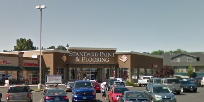
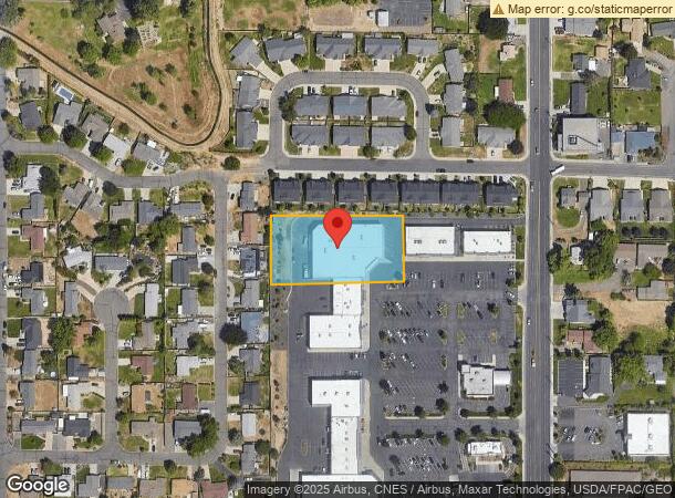
Property Record
130 S 72Nd Ave, Yakima, WA 98908
NEARBY LISTINGS FOR SALE OR LEASE
Property Detail
130 S 72Nd Ave
Yakima, WA
Sp 7614971
181320-34488
SECTION 20 TOWNSHIP 13 RANGE 18 QUARTER SW SP 7614971 LOT 9 ALSO TH PTN LOT 8 OF SD SP DESC AS FOL BEG NW COR OF SD LOT 8, TH N 88^ 55' 43 E 320.93 FT TO W'LY LN OF LOT 10 OF SD SP, TH S 01^ 04' 17 E 2.20 FT, TH S 88^ 55' 43 W 320.03 FT, TH N 01^ 04'
Storebuilding
Yakima
X
Washington
53077C1030E
9
2024
1.17 AC
2023
Outlying Yakima County
000904
Yakima
22,926 SF
DEMOGRAPHICS near 130 S 72Nd Ave
1 Mile
3 Mile
5 Mile
2024 Total Population
12,388
49,714
103,856
2029 Population
12,712
50,383
104,609
Pop Growth 2024-2029
+ 2.62%
+ 1.35%
+ 0.73%
Average Age
40
41
38
2024 Total Households
4,867
19,906
38,347
HH Growth 2024-2029
+ 2.40%
+ 1.32%
+ 0.70%
Median Household Inc
$72,949
$68,100
$60,825
Avg Household Size
2.50
2.40
2.60
2024 Avg HH Vehicles
2.00
2.00
2.00
Median Home Value
$299,629
$298,514
$273,759
Median Year Built
1990
1979
1974
Nearby Places
- Restaurants
- Banks
- Shops
- Fitness
- Groceries
PUBLIC TRANSPORTATION
AIRPORT
Yakima Air Trml/McAllister Field
DRIVE
WALK
Distance
Yakima Air Trml/McAllister Field
10 min
4.6 mi
Freight Ports
Port of Tacoma
DRIVE
WALK
Distance
Port of Tacoma
191 min
160.0 mi
Nearby Properties
Address
Land Use
TOTAL SIZE
Lot Size
Zoning
Address
Land Use
TOTAL SIZE
Lot Size
Zoning
331,736 SF
34.95 AC
R1
Address
Land Use
TOTAL SIZE
Lot Size
Zoning
409,453 SF
8.25 AC
R3
Address
Land Use
TOTAL SIZE
Lot Size
Zoning
275,342 SF
16.10 AC
R1
Address
Land Use
TOTAL SIZE
Lot Size
Zoning
226,069 SF
6.87 AC
GC
Address
Land Use
TOTAL SIZE
Lot Size
Zoning
119,023 SF
7.42 AC
R3
Address
Land Use
TOTAL SIZE
Lot Size
Zoning
205,680 SF
24.88 AC
COM
Address
Land Use
TOTAL SIZE
Lot Size
Zoning
114,192 SF
5.07 AC
GC
Address
Land Use
TOTAL SIZE
Lot Size
Zoning
107,078 SF
14.96 AC
R1
Address
Land Use
TOTAL SIZE
Lot Size
Zoning
132,213 SF
4 AC
R3
Address
Land Use
TOTAL SIZE
Lot Size
Zoning
69,675 SF
7.49 AC
R1
Address
Land Use
TOTAL SIZE
Lot Size
Zoning
65,606 SF
3.39 AC
R2
Address
Land Use
TOTAL SIZE
Lot Size
Zoning
69,675 SF
10.48 AC
R1
Address
Land Use
TOTAL SIZE
Lot Size
Zoning
162,933 SF
14.96 AC
SCC
Address
Land Use
TOTAL SIZE
Lot Size
Zoning
105,756 SF
6.89 AC
R3
Address
Land Use
TOTAL SIZE
Lot Size
Zoning
130,114 SF
27.76 AC
R1
Address
Land Use
TOTAL SIZE
Lot Size
Zoning
118,830 SF
5.34 AC
LCC
Address
Land Use
TOTAL SIZE
Lot Size
Zoning
29,752 SF
2.17 AC
B1
Address
Land Use
TOTAL SIZE
Lot Size
Zoning
65,968 SF
1.51 AC
R2
Address
Land Use
TOTAL SIZE
Lot Size
Zoning
116,192 SF
6.34 AC
R3
Address
Land Use
TOTAL SIZE
Lot Size
Zoning
57,223 SF
2.98 AC
B1
Address
Land Use
TOTAL SIZE
Lot Size
Zoning
81,126 SF
3.98 AC
R3
Address
Land Use
TOTAL SIZE
Lot Size
Zoning
43,167 SF
2.90 AC
BCOM
Address
Land Use
TOTAL SIZE
Lot Size
Zoning
49,899 SF
1.22 AC
R3
Address
Land Use
TOTAL SIZE
Lot Size
Zoning
62,968 SF
14.24 AC
R1
Address
Land Use
TOTAL SIZE
Lot Size
Zoning
109,369 SF
4.42 AC
R1
Address
Land Use
TOTAL SIZE
Lot Size
Zoning
30,041 SF
4.12 AC
B1
Address
Land Use
TOTAL SIZE
Lot Size
Zoning
77,340 SF
2.04 AC
R3
Address
Land Use
TOTAL SIZE
Lot Size
Zoning
68,852 SF
3.37 AC
R3
Address
Land Use
TOTAL SIZE
Lot Size
Zoning
58,086 SF
8.12 AC
GC
Address
Land Use
TOTAL SIZE
Lot Size
Zoning
80,981 SF
7 AC
LCC
The World's #1 Commercial Real Estate Marketplace
Connect with us
© 2025 CoStar Group
The information above has been obtained from sources believed reliable. While we do not doubt its accuracy we have not verified it and make no guarantee, warranty or representation about it. It is your responsibility to independently confirm its accuracy and completeness. Any projections, opinions, assumptions, or estimates used are for example only and do not represent the current or future performance of the property. The value of this transaction to you depends on tax and other factors which should be evaluated by your tax, financial, and legal advisors. You and your advisors should conduct a careful, independent investigation of the property to determine to your satisfaction the suitability of the property for your needs.