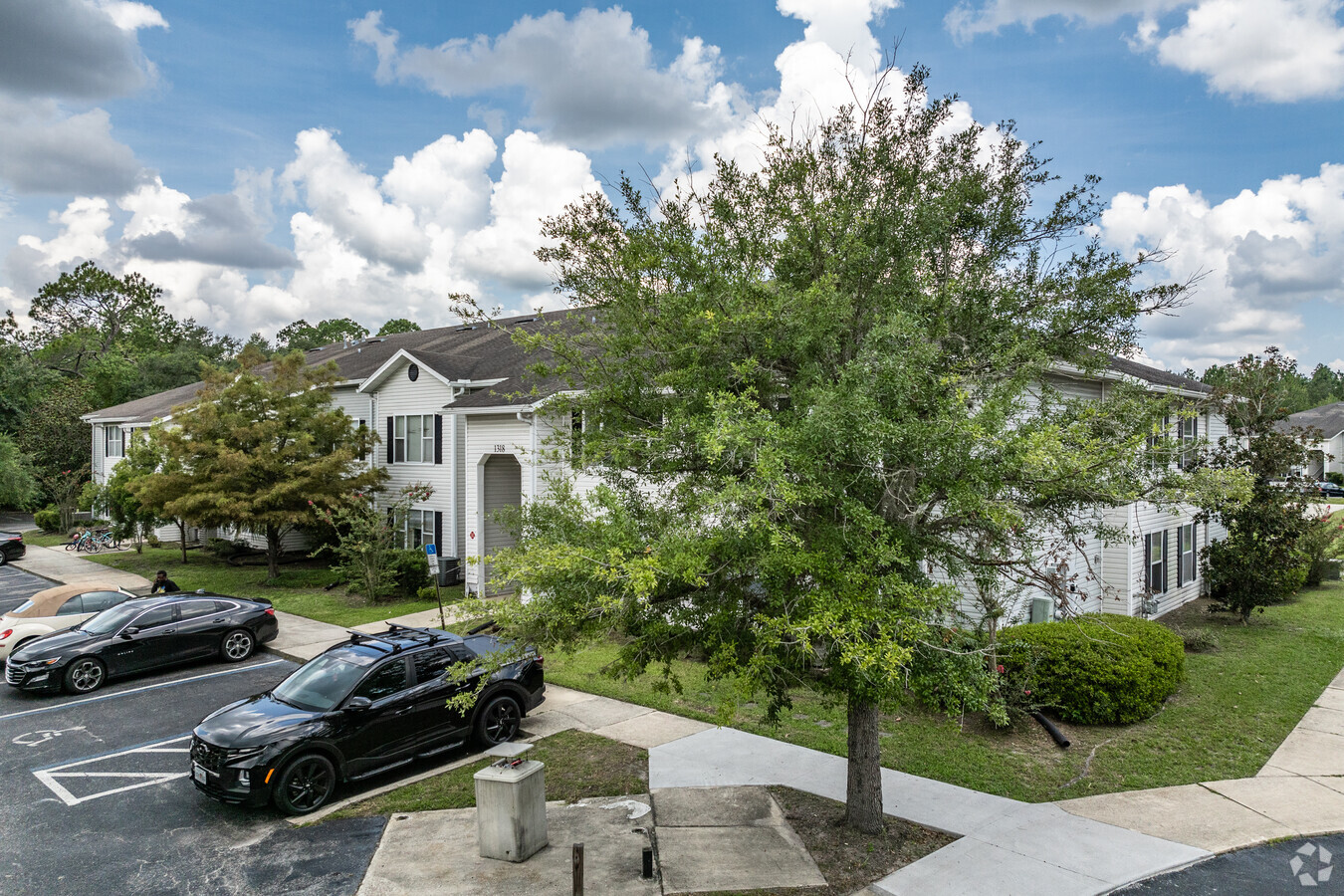
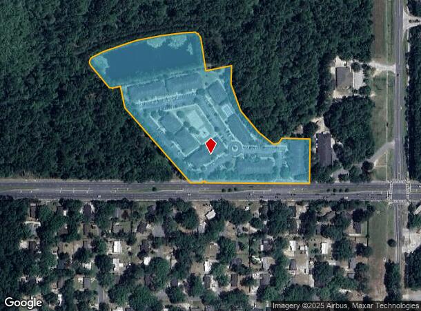
Property Record
1300 Ne 39Th Ave, Gainesville, FL 32609
NEARBY LISTINGS FOR SALE OR LEASE
Property Detail
1300 Ne 39Th Ave
Gainesville, FL
Minor S/D, Boundary Survey Parcel 8159
08159-010-001
COM SE COR SEC S 00 DEG 53 MIN 38 SEC E 13 FT W 1109.64 FT N 50 FT E 25 FT N 50.70 FT POB N 42 DEG 29 MIN 48 SEC W 425.16 FT N 12 DEG 29 MIN 48 SEC W 104.31 FT S 77 DEG 30 MIN 12 SEC W 34.62 FT NWLY ALG CURVE 34.61 FT N 40 DEG 31 MIN 09 SEC W 124.78
Multifamilydwelling
Alachua
A
Florida
12001C0308D
1
2023
9.73 AC
2024
Gainesville
001902
Other Market Areas
115,389 SF
DEMOGRAPHICS near 1300 Ne 39Th Ave
1 Mile
3 Mile
5 Mile
2024 Total Population
4,107
37,993
104,560
2029 Population
4,343
40,318
109,907
Pop Growth 2024-2029
+ 5.75%
+ 6.12%
+ 5.11%
Average Age
36
37
35
2024 Total Households
1,653
16,651
41,232
HH Growth 2024-2029
+ 5.93%
+ 6.02%
+ 5.43%
Median Household Inc
$36,755
$41,281
$44,502
Avg Household Size
2.40
2.20
2.20
2024 Avg HH Vehicles
1.00
1.00
2.00
Median Home Value
$97,667
$168,252
$189,998
Median Year Built
1976
1975
1977
Nearby Places
- Restaurants
- Banks
- Shops
- Fitness
- Groceries
PUBLIC TRANSPORTATION
AIRPORT
Gainesville Regional
DRIVE
WALK
Distance
Gainesville Regional
9 min
2.9 mi
Freight Ports
Jacksonville Port
DRIVE
WALK
Distance
Jacksonville Port
94 min
72.7 mi
Nearby Properties
Address
Land Use
TOTAL SIZE
Lot Size
Zoning
Address
Land Use
TOTAL SIZE
Lot Size
Zoning
25.64 AC
PS
Address
Land Use
TOTAL SIZE
Lot Size
Zoning
594,946 SF
4.47 AC
DT
Address
Land Use
TOTAL SIZE
Lot Size
Zoning
279,647 SF
1.66 AC
PD
Address
Land Use
TOTAL SIZE
Lot Size
Zoning
362,539 SF
2.11 AC
U8
Address
Land Use
TOTAL SIZE
Lot Size
Zoning
404,722 SF
2.82 AC
U6
Address
Land Use
TOTAL SIZE
Lot Size
Zoning
1,331,605 SF
32.61 AC
ED
Address
Land Use
TOTAL SIZE
Lot Size
Zoning
60,480 SF
117.68 AC
PS
Address
Land Use
TOTAL SIZE
Lot Size
Zoning
444,350 SF
4.38 AC
DT
Address
Land Use
TOTAL SIZE
Lot Size
Zoning
389,624 SF
7.21 AC
PD
Address
Land Use
TOTAL SIZE
Lot Size
Zoning
346,154 SF
22.02 AC
U6
Address
Land Use
TOTAL SIZE
Lot Size
Zoning
308,599 SF
639 AC
A
Address
Land Use
TOTAL SIZE
Lot Size
Zoning
254,026 SF
24.75 AC
RMF6
Address
Land Use
TOTAL SIZE
Lot Size
Zoning
341,625 SF
1,093.63 AC
AF
Address
Land Use
TOTAL SIZE
Lot Size
Zoning
125,495 SF
19.11 AC
ED
Address
Land Use
TOTAL SIZE
Lot Size
Zoning
233,458 SF
16.30 AC
PD
Address
Land Use
TOTAL SIZE
Lot Size
Zoning
3 SF
14.81 AC
ED
Address
Land Use
TOTAL SIZE
Lot Size
Zoning
93,004 SF
37.39 AC
ED
Address
Land Use
TOTAL SIZE
Lot Size
Zoning
85,476 SF
17.92 AC
MP
Address
Land Use
TOTAL SIZE
Lot Size
Zoning
41,000 SF
155.49 AC
PS
Address
Land Use
TOTAL SIZE
Lot Size
Zoning
206,923 SF
15.32 AC
ED
Address
Land Use
TOTAL SIZE
Lot Size
Zoning
134,018 SF
1.21 AC
PD
Address
Land Use
TOTAL SIZE
Lot Size
Zoning
90,488 SF
14.67 AC
ED
Address
Land Use
TOTAL SIZE
Lot Size
Zoning
174,781 SF
16.83 AC
U8
Address
Land Use
TOTAL SIZE
Lot Size
Zoning
34,713 SF
3.49 AC
DT
Address
Land Use
TOTAL SIZE
Lot Size
Zoning
169,796 SF
15.61 AC
U8
Address
Land Use
TOTAL SIZE
Lot Size
Zoning
84,469 SF
13.37 AC
ED
Address
Land Use
TOTAL SIZE
Lot Size
Zoning
118,896 SF
7.16 AC
PS
Address
Land Use
TOTAL SIZE
Lot Size
Zoning
89,603 SF
0.06 AC
DT
Address
Land Use
TOTAL SIZE
Lot Size
Zoning
351,294 SF
94.41 AC
ED
Address
Land Use
TOTAL SIZE
Lot Size
Zoning
71,879 SF
0.35 AC
DT
The World's #1 Commercial Real Estate Marketplace
Connect with us
© 2025 CoStar Group
The information above has been obtained from sources believed reliable. While we do not doubt its accuracy we have not verified it and make no guarantee, warranty or representation about it. It is your responsibility to independently confirm its accuracy and completeness. Any projections, opinions, assumptions, or estimates used are for example only and do not represent the current or future performance of the property. The value of this transaction to you depends on tax and other factors which should be evaluated by your tax, financial, and legal advisors. You and your advisors should conduct a careful, independent investigation of the property to determine to your satisfaction the suitability of the property for your needs.