Property Record
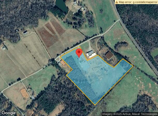
1300 Ross Rd, Shady Dale, GA 31085
NEARBY LISTINGS FOR SALE OR LEASE
-
-
View all Shady Dale listings for sale on LoopNet.com
Property Detail
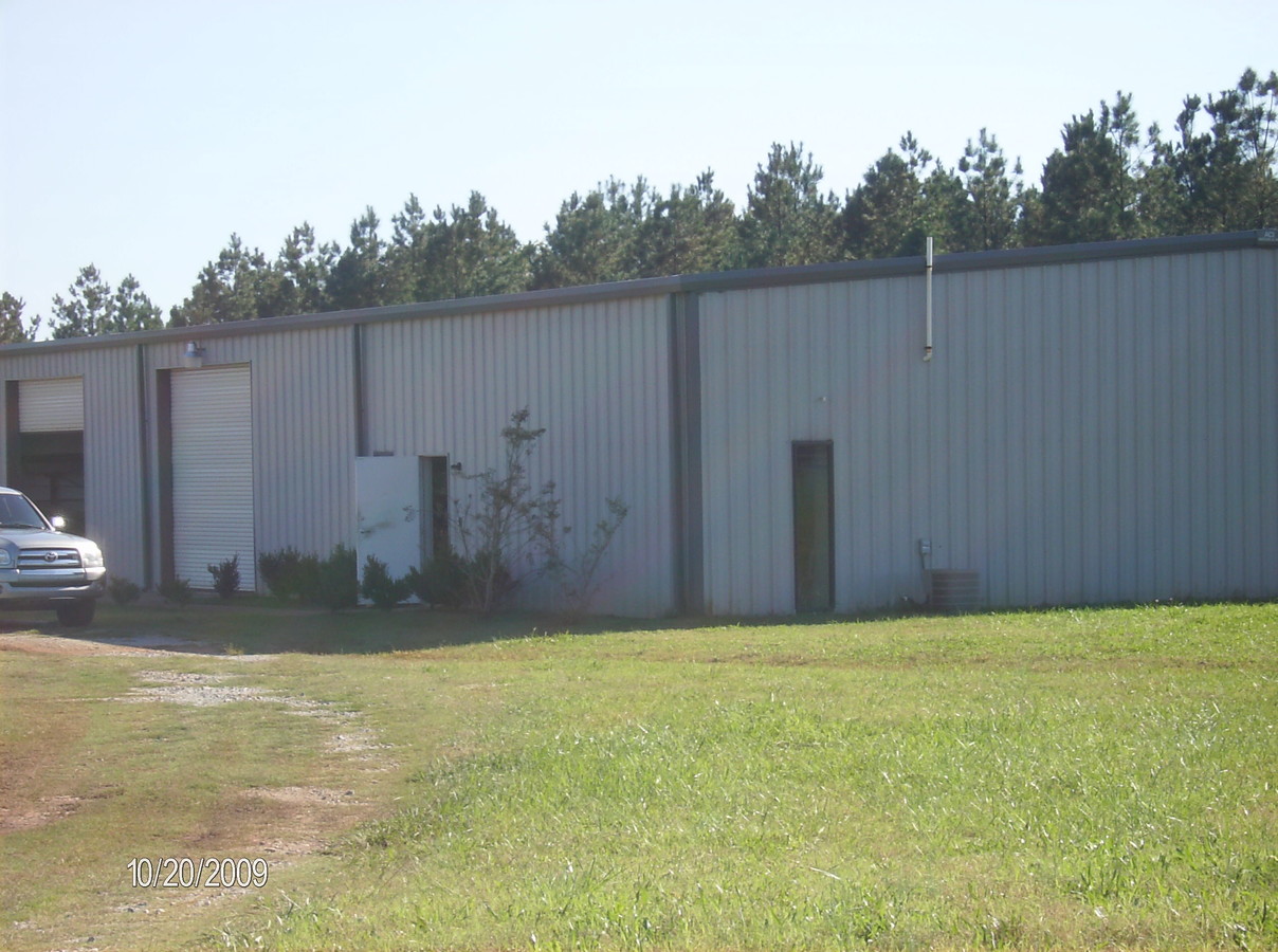
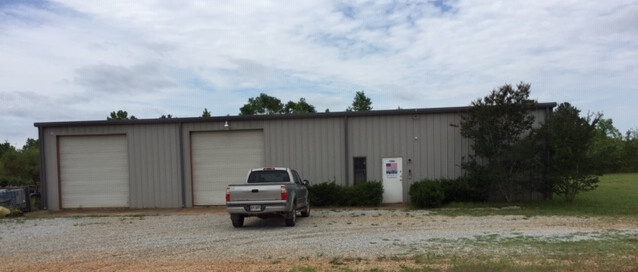
1300 Ross Rd
011-063
PB12/179 DB1120/216 & 218
Manufacturinglight
Jasper
X
Georgia
13211C0275B
30.80 AC
2024
Jasper County
2024
Atlanta
010100
Atlanta-Sandy Springs-Roswell, GA
4,800 SF
DEMOGRAPHICS near 1300 Ross Rd
1 Mile
3 Mile
5 Mile
2024 Total Population
138
998
2,890
2029 Population
168
1,215
3,504
Pop Growth 2024-2029
+ 21.74%
+ 21.74%
+ 21.25%
Average Age
41
41
41
2024 Total Households
48
351
1,020
HH Growth 2024-2029
+ 20.83%
+ 21.37%
+ 20.78%
Median Household Inc
$77,885
$61,875
$65,204
Avg Household Size
2.60
2.70
2.70
2024 Avg HH Vehicles
2.00
2.00
2.00
Median Home Value
$304,545
$239,473
$242,437
Median Year Built
1995
1995
1995
Nearby Places
- Restaurants
- Banks
- Shops
- Fitness
- Groceries
SALE & LEASE HISTORY
LISTING DATE
SALE/LEASE

Oct 11, 2017
For Sale
Jun 26, 2019
For Sale
Dec 14, 2020
For Sale
Dec 08, 2017
For Sale
Dec 06, 2017
For Sale
Nearby Properties
Address
Land Use
TOTAL SIZE
Lot Size
Zoning
Address
Land Use
TOTAL SIZE
Lot Size
Zoning
12,020 SF
8.50 AC
AG
Address
Land Use
TOTAL SIZE
Lot Size
Zoning
1,065.96 AC
AG
Address
Land Use
TOTAL SIZE
Lot Size
Zoning
918.96 AC
AG
Address
Land Use
TOTAL SIZE
Lot Size
Zoning
837.90 AC
AG
Address
Land Use
TOTAL SIZE
Lot Size
Zoning
666.70 AC
AG
Address
Land Use
TOTAL SIZE
Lot Size
Zoning
473.10 AC
AG
Address
Land Use
TOTAL SIZE
Lot Size
Zoning
325.39 AC
AG
Address
Land Use
TOTAL SIZE
Lot Size
Zoning
42,000 SF
16.92 AC
M-2
Address
Land Use
TOTAL SIZE
Lot Size
Zoning
590.16 AC
AG
Address
Land Use
TOTAL SIZE
Lot Size
Zoning
333.69 AC
AG
Address
Land Use
TOTAL SIZE
Lot Size
Zoning
164 AC
AG
Address
Land Use
TOTAL SIZE
Lot Size
Zoning
264.71 AC
AG
Address
Land Use
TOTAL SIZE
Lot Size
Zoning
160.24 AC
AG
Address
Land Use
TOTAL SIZE
Lot Size
Zoning
12,400 SF
2.76 AC
M-1
Address
Land Use
TOTAL SIZE
Lot Size
Zoning
222.61 AC
AG
Address
Land Use
TOTAL SIZE
Lot Size
Zoning
237.27 AC
AG
Address
Land Use
TOTAL SIZE
Lot Size
Zoning
198.14 AC
AG
Address
Land Use
TOTAL SIZE
Lot Size
Zoning
292.48 AC
AG
Address
Land Use
TOTAL SIZE
Lot Size
Zoning
210 AC
AG
Address
Land Use
TOTAL SIZE
Lot Size
Zoning
144.32 AC
AG
Address
Land Use
TOTAL SIZE
Lot Size
Zoning
198.73 AC
AG
Address
Land Use
TOTAL SIZE
Lot Size
Zoning
265 AC
AG
Address
Land Use
TOTAL SIZE
Lot Size
Zoning
132.78 AC
AG
Address
Land Use
TOTAL SIZE
Lot Size
Zoning
43.64 AC
AG
Address
Land Use
TOTAL SIZE
Lot Size
Zoning
7,192 SF
2 AC
M-1
Address
Land Use
TOTAL SIZE
Lot Size
Zoning
68.86 AC
AG
Address
Land Use
TOTAL SIZE
Lot Size
Zoning
60.86 AC
AG
Address
Land Use
TOTAL SIZE
Lot Size
Zoning
40.03 AC
AG
Address
Land Use
TOTAL SIZE
Lot Size
Zoning
145.45 AC
AG
The World's #1 Commercial Real Estate Marketplace
Connect with us
© 2025 CoStar Group
The information above has been obtained from sources believed reliable. While we do not doubt its accuracy we have not verified it and make no guarantee, warranty or representation about it. It is your responsibility to independently confirm its accuracy and completeness. Any projections, opinions, assumptions, or estimates used are for example only and do not represent the current or future performance of the property. The value of this transaction to you depends on tax and other factors which should be evaluated by your tax, financial, and legal advisors. You and your advisors should conduct a careful, independent investigation of the property to determine to your satisfaction the suitability of the property for your needs.