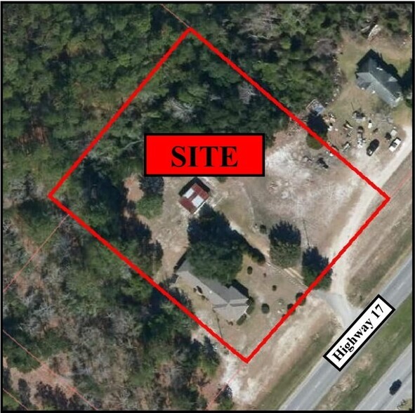
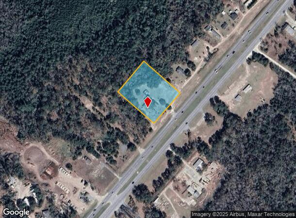
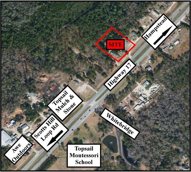
Property Record
13111 Us Highway 17, Hampstead, NC 28443
NEARBY LISTINGS FOR SALE OR LEASE
Property Detail
13111 Us Highway 17
Wilmington, NC
Pender
3282-31-1385-0000
North Carolina
Sfr
2.06 AC
X
East Pender County
3720328200J
Wilmington
1,576 SF
DEMOGRAPHICS near 13111 Us Highway 17
1 Mile
3 Mile
5 Mile
2024 Total Population
1,007
8,959
22,943
2029 Population
1,225
10,921
27,144
Pop Growth 2024-2029
+ 21.65%
+ 21.90%
+ 18.31%
Average Age
41
41
43
2024 Total Households
384
3,354
8,930
HH Growth 2024-2029
+ 21.88%
+ 22.18%
+ 18.29%
Median Household Inc
$108,333
$107,989
$105,198
Avg Household Size
2.60
2.70
2.50
2024 Avg HH Vehicles
2.00
2.00
2.00
Median Home Value
$381,147
$362,915
$360,416
Median Year Built
2002
2003
2002
Nearby Places
- Restaurants
- Banks
- Shops
- Fitness
- Groceries
PUBLIC TRANSPORTATION
AIRPORT
Wilmington International
DRIVE
WALK
Distance
Wilmington International
26 min
17.0 mi
Freight Ports
Port of Wilmington
DRIVE
WALK
Distance
Port of Wilmington
33 min
18.9 mi
SALE & LEASE HISTORY
LISTING DATE
SALE/LEASE

Nov 02, 2022
For Sale
Nearby Properties
Address
Land Use
TOTAL SIZE
Lot Size
Zoning
Address
Land Use
TOTAL SIZE
Lot Size
Zoning
184,632 SF
17.30 AC
PD
Address
Land Use
TOTAL SIZE
Lot Size
Zoning
90,501 SF
7.03 AC
GB
Address
Land Use
TOTAL SIZE
Lot Size
Zoning
52,259 SF
11.40 AC
R20
Address
Land Use
TOTAL SIZE
Lot Size
Zoning
9.72 AC
Address
Land Use
TOTAL SIZE
Lot Size
Zoning
3.41 AC
Address
Land Use
TOTAL SIZE
Lot Size
Zoning
2,921.99 AC
SEEMAP
Address
Land Use
TOTAL SIZE
Lot Size
Zoning
21,831 SF
9.76 AC
SEEMAP
Address
Land Use
TOTAL SIZE
Lot Size
Zoning
45,636 SF
6.45 AC
GB
Address
Land Use
TOTAL SIZE
Lot Size
Zoning
24,000 SF
2.79 AC
B2
Address
Land Use
TOTAL SIZE
Lot Size
Zoning
11,828 SF
1 AC
Address
Land Use
TOTAL SIZE
Lot Size
Zoning
1,324.37 AC
RA
Address
Land Use
TOTAL SIZE
Lot Size
Zoning
2,874 SF
5.70 AC
SEEMAP
Address
Land Use
TOTAL SIZE
Lot Size
Zoning
41.76 AC
GB
Address
Land Use
TOTAL SIZE
Lot Size
Zoning
28,800 SF
1 AC
R20C
Address
Land Use
TOTAL SIZE
Lot Size
Zoning
18,000 SF
6.70 AC
Address
Land Use
TOTAL SIZE
Lot Size
Zoning
1,260.65 AC
SEEMAP
Address
Land Use
TOTAL SIZE
Lot Size
Zoning
14,699 SF
1.50 AC
B3
Address
Land Use
TOTAL SIZE
Lot Size
Zoning
12,820 SF
2.30 AC
SEEMAP
Address
Land Use
TOTAL SIZE
Lot Size
Zoning
8.19 AC
SEEMAP
Address
Land Use
TOTAL SIZE
Lot Size
Zoning
8,970 SF
3.21 AC
SEEMAP
Address
Land Use
TOTAL SIZE
Lot Size
Zoning
25,000 SF
1.96 AC
SEEMAP
Address
Land Use
TOTAL SIZE
Lot Size
Zoning
12,772 SF
1.13 AC
GB
Address
Land Use
TOTAL SIZE
Lot Size
Zoning
6,621 SF
2.43 AC
GB
Address
Land Use
TOTAL SIZE
Lot Size
Zoning
3,038 SF
6.81 AC
SEEMAP
Address
Land Use
TOTAL SIZE
Lot Size
Zoning
2,560 SF
2.25 AC
SEEMAP
Address
Land Use
TOTAL SIZE
Lot Size
Zoning
11,852 SF
0.45 AC
B2
Address
Land Use
TOTAL SIZE
Lot Size
Zoning
7,102 SF
13.49 AC
SEEMAP
Address
Land Use
TOTAL SIZE
Lot Size
Zoning
0.26 AC
Address
Land Use
TOTAL SIZE
Lot Size
Zoning
22,000 SF
2.34 AC
B2
The World's #1 Commercial Real Estate Marketplace
Connect with us
© 2025 CoStar Group
The information above has been obtained from sources believed reliable. While we do not doubt its accuracy we have not verified it and make no guarantee, warranty or representation about it. It is your responsibility to independently confirm its accuracy and completeness. Any projections, opinions, assumptions, or estimates used are for example only and do not represent the current or future performance of the property. The value of this transaction to you depends on tax and other factors which should be evaluated by your tax, financial, and legal advisors. You and your advisors should conduct a careful, independent investigation of the property to determine to your satisfaction the suitability of the property for your needs.