Property Record
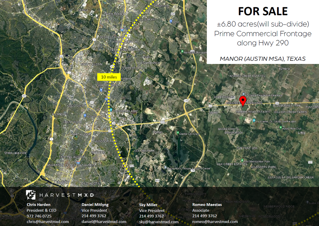
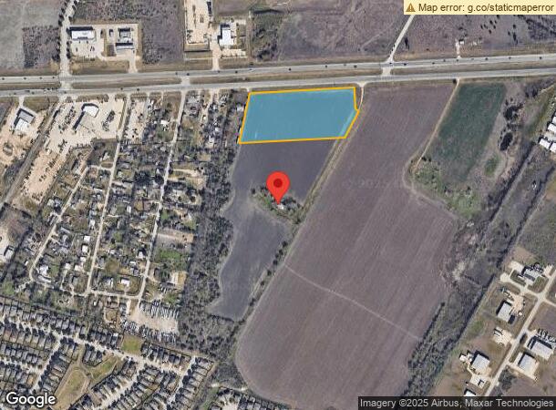
13119 Us Highway 290 E, Manor, TX 78653
NEARBY LISTINGS FOR SALE OR LEASE
Property Detail
13119 Us Highway 290 E
Austin-Round Rock, TX
Manor Addn
236864
6.7962AC OF LOT 1 MANOR ADDN
Farms
Travis
X
Texas
48453C0485J
1
2023
6.79 AC
2023
East
0022091056
Austin
1,632 SF
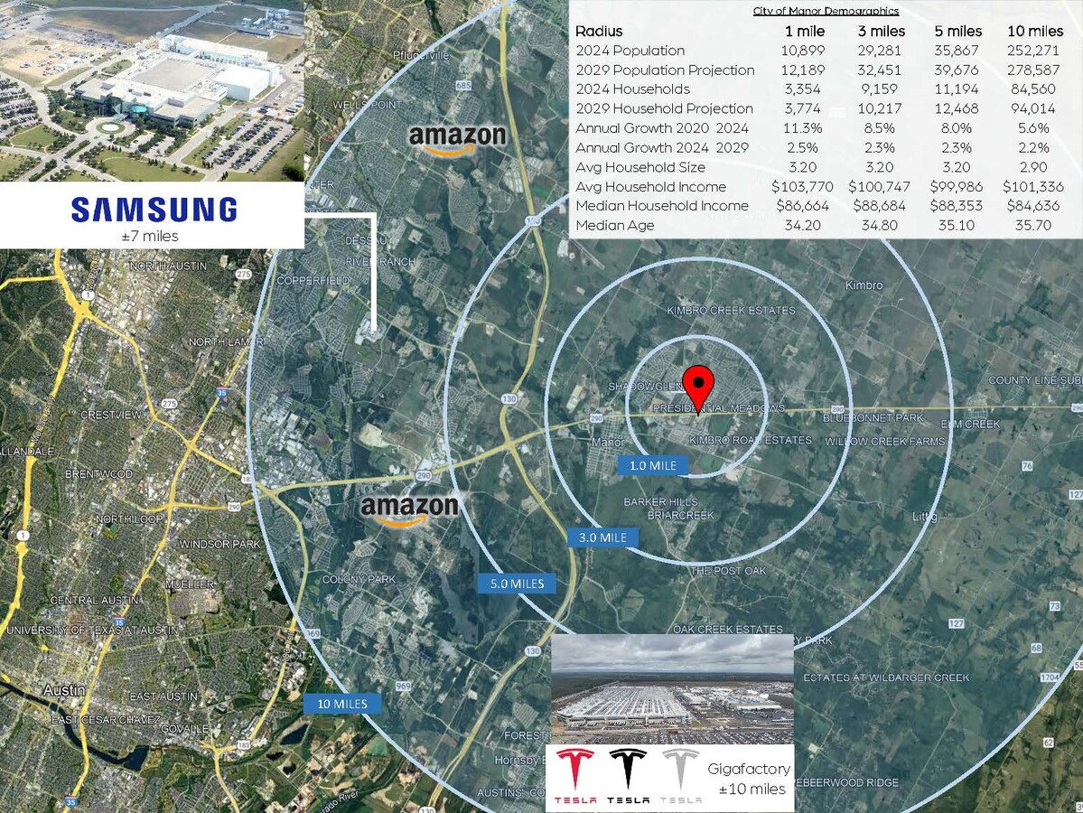
DEMOGRAPHICS near 13119 Us Highway 290 E
1 Mile
3 Mile
5 Mile
2024 Total Population
11,010
29,378
35,515
2029 Population
12,328
32,567
39,347
Pop Growth 2024-2029
+ 11.97%
+ 10.86%
+ 10.79%
Average Age
34
34
35
2024 Total Households
3,390
9,192
11,147
HH Growth 2024-2029
+ 12.65%
+ 11.58%
+ 11.54%
Median Household Inc
$85,090
$88,575
$88,974
Avg Household Size
3.20
3.20
3.10
2024 Avg HH Vehicles
2.00
2.00
2.00
Median Home Value
$230,986
$242,801
$249,687
Median Year Built
2010
2010
2010
Nearby Places
- Restaurants
- Banks
- Shops
- Fitness
- Groceries
PUBLIC TRANSPORTATION
AIRPORT
Austin-Bergstrom International
DRIVE
WALK
Distance
Austin-Bergstrom International
32 min
20.4 mi
Freight Ports
Calhoun Port
DRIVE
WALK
Distance
Calhoun Port
192 min
163.4 mi
SALE & LEASE HISTORY
LISTING DATE
SALE/LEASE

Oct 12, 2023
For Sale
Feb 27, 2024
For Sale
Apr 26, 2022
For Sale
Nearby Properties
Address
Land Use
TOTAL SIZE
Lot Size
Zoning
Address
Land Use
TOTAL SIZE
Lot Size
Zoning
411,429 SF
61.03 AC
Address
Land Use
TOTAL SIZE
Lot Size
Zoning
264,000 SF
14.22 AC
Address
Land Use
TOTAL SIZE
Lot Size
Zoning
300,492 SF
13.20 AC
Address
Land Use
TOTAL SIZE
Lot Size
Zoning
323,425 SF
14.20 AC
Address
Land Use
TOTAL SIZE
Lot Size
Zoning
266,564 SF
27.40 AC
Address
Land Use
TOTAL SIZE
Lot Size
Zoning
223,575 SF
12.47 AC
Address
Land Use
TOTAL SIZE
Lot Size
Zoning
204,356 SF
12.18 AC
Address
Land Use
TOTAL SIZE
Lot Size
Zoning
255,750 SF
13.38 AC
Address
Land Use
TOTAL SIZE
Lot Size
Zoning
111,966 SF
11.61 AC
Address
Land Use
TOTAL SIZE
Lot Size
Zoning
149,640 SF
10.39 AC
Address
Land Use
TOTAL SIZE
Lot Size
Zoning
109,184 SF
13.45 AC
Address
Land Use
TOTAL SIZE
Lot Size
Zoning
147,908 SF
15.54 AC
Address
Land Use
TOTAL SIZE
Lot Size
Zoning
191,300 SF
30.73 AC
Address
Land Use
TOTAL SIZE
Lot Size
Zoning
261,594 SF
6.66 AC
Address
Land Use
TOTAL SIZE
Lot Size
Zoning
217,783 SF
4.27 AC
Address
Land Use
TOTAL SIZE
Lot Size
Zoning
132,500 SF
15.56 AC
Address
Land Use
TOTAL SIZE
Lot Size
Zoning
51,910 SF
13.19 AC
Address
Land Use
TOTAL SIZE
Lot Size
Zoning
80,872 SF
14.75 AC
Address
Land Use
TOTAL SIZE
Lot Size
Zoning
18.08 AC
Address
Land Use
TOTAL SIZE
Lot Size
Zoning
26,374 SF
3.66 AC
Address
Land Use
TOTAL SIZE
Lot Size
Zoning
1,632 SF
24.07 AC
Address
Land Use
TOTAL SIZE
Lot Size
Zoning
34,061 SF
19.01 AC
Address
Land Use
TOTAL SIZE
Lot Size
Zoning
343,200 SF
21.79 AC
Address
Land Use
TOTAL SIZE
Lot Size
Zoning
25,495 SF
5.95 AC
Address
Land Use
TOTAL SIZE
Lot Size
Zoning
35,016 SF
4.27 AC
Address
Land Use
TOTAL SIZE
Lot Size
Zoning
71,436 SF
8 AC
Address
Land Use
TOTAL SIZE
Lot Size
Zoning
12.08 AC
Address
Land Use
TOTAL SIZE
Lot Size
Zoning
25.85 AC
Address
Land Use
TOTAL SIZE
Lot Size
Zoning
14.73 AC
Address
Land Use
TOTAL SIZE
Lot Size
Zoning
44,216 SF
19.69 AC
The World's #1 Commercial Real Estate Marketplace
Connect with us
© 2025 CoStar Group
The information above has been obtained from sources believed reliable. While we do not doubt its accuracy we have not verified it and make no guarantee, warranty or representation about it. It is your responsibility to independently confirm its accuracy and completeness. Any projections, opinions, assumptions, or estimates used are for example only and do not represent the current or future performance of the property. The value of this transaction to you depends on tax and other factors which should be evaluated by your tax, financial, and legal advisors. You and your advisors should conduct a careful, independent investigation of the property to determine to your satisfaction the suitability of the property for your needs.