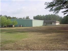
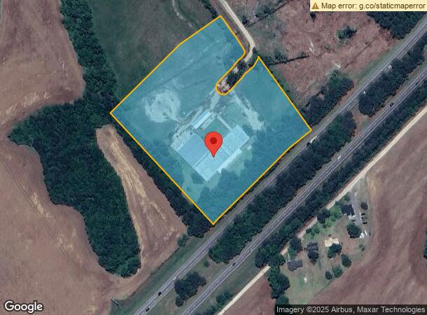
Property Record
1315 20Th Century Ln, Manning, SC 29102
NEARBY LISTINGS FOR SALE OR LEASE
-
-
View all Manning listings for sale on LoopNet.com
Property Detail
1315 20Th Century Ln
Commercialnec
Duvalle Elliott Rls
X
Clarendon
45027C0243C
South Carolina
2023
10.90 AC
2023
Other Market Areas
960801
122-00-03-013-00
3,480 SF
DEMOGRAPHICS near 1315 20Th Century Ln
1 Mile
3 Mile
5 Mile
2024 Total Population
132
1,013
5,848
2029 Population
125
972
5,582
Pop Growth 2024-2029
(5.30%)
(4.05%)
(4.55%)
Average Age
46
44
44
2024 Total Households
57
433
2,446
HH Growth 2024-2029
(5.26%)
(3.93%)
(4.42%)
Median Household Inc
$43,333
$43,967
$42,573
Avg Household Size
2.30
2.30
2.30
2024 Avg HH Vehicles
2.00
2.00
2.00
Median Home Value
$159,999
$141,935
$124,000
Median Year Built
1989
1989
1986
Nearby Places
- Restaurants
- Banks
- Shops
- Fitness
- Groceries
Nearby Properties
Address
Land Use
TOTAL SIZE
Lot Size
Zoning
Address
Land Use
TOTAL SIZE
Lot Size
Zoning
Address
Land Use
TOTAL SIZE
Lot Size
Zoning
220,086 SF
24.36 AC
Address
Land Use
TOTAL SIZE
Lot Size
Zoning
90,656 SF
15.48 AC
Address
Land Use
TOTAL SIZE
Lot Size
Zoning
48,000 SF
9.30 AC
Address
Land Use
TOTAL SIZE
Lot Size
Zoning
24,452 SF
13 AC
Address
Land Use
TOTAL SIZE
Lot Size
Zoning
50,000 SF
20.19 AC
Address
Land Use
TOTAL SIZE
Lot Size
Zoning
8.52 AC
Address
Land Use
TOTAL SIZE
Lot Size
Zoning
24.80 AC
Address
Land Use
TOTAL SIZE
Lot Size
Zoning
41.72 AC
Address
Land Use
TOTAL SIZE
Lot Size
Zoning
Address
Land Use
TOTAL SIZE
Lot Size
Zoning
2,398 SF
25.09 AC
Address
Land Use
TOTAL SIZE
Lot Size
Zoning
49.95 AC
Address
Land Use
TOTAL SIZE
Lot Size
Zoning
46.36 AC
Address
Land Use
TOTAL SIZE
Lot Size
Zoning
52,166 SF
15 AC
Address
Land Use
TOTAL SIZE
Lot Size
Zoning
7,380 SF
29.20 AC
Address
Land Use
TOTAL SIZE
Lot Size
Zoning
1,798 SF
1 AC
Address
Land Use
TOTAL SIZE
Lot Size
Zoning
273,438 SF
48 AC
Address
Land Use
TOTAL SIZE
Lot Size
Zoning
8.53 AC
Address
Land Use
TOTAL SIZE
Lot Size
Zoning
6,930 SF
16.20 AC
Address
Land Use
TOTAL SIZE
Lot Size
Zoning
9,230 SF
2 AC
Address
Land Use
TOTAL SIZE
Lot Size
Zoning
8,070 SF
2.58 AC
Address
Land Use
TOTAL SIZE
Lot Size
Zoning
10,560 SF
3 AC
Address
Land Use
TOTAL SIZE
Lot Size
Zoning
Address
Land Use
TOTAL SIZE
Lot Size
Zoning
4,230 SF
5.69 AC
Address
Land Use
TOTAL SIZE
Lot Size
Zoning
Address
Land Use
TOTAL SIZE
Lot Size
Zoning
Address
Land Use
TOTAL SIZE
Lot Size
Zoning
36,404 SF
3.80 AC
Address
Land Use
TOTAL SIZE
Lot Size
Zoning
1.75 AC
Address
Land Use
TOTAL SIZE
Lot Size
Zoning
6,588 SF
1.80 AC
Address
Land Use
TOTAL SIZE
Lot Size
Zoning
The World's #1 Commercial Real Estate Marketplace
Connect with us
© 2025 CoStar Group
The information above has been obtained from sources believed reliable. While we do not doubt its accuracy we have not verified it and make no guarantee, warranty or representation about it. It is your responsibility to independently confirm its accuracy and completeness. Any projections, opinions, assumptions, or estimates used are for example only and do not represent the current or future performance of the property. The value of this transaction to you depends on tax and other factors which should be evaluated by your tax, financial, and legal advisors. You and your advisors should conduct a careful, independent investigation of the property to determine to your satisfaction the suitability of the property for your needs.