Property Record
1315 Nw Northwest Dr Nw, Atlanta, GA 30318
NEARBY LISTINGS FOR SALE OR LEASE
-
-
-
-
No Photo
-
-
-
-
-
View all Atlanta listings for sale on LoopNet.com
Property Detail
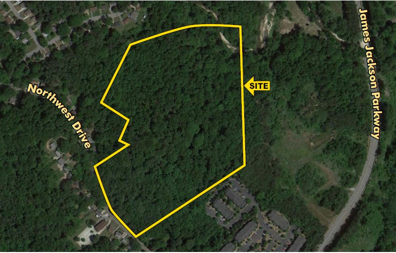
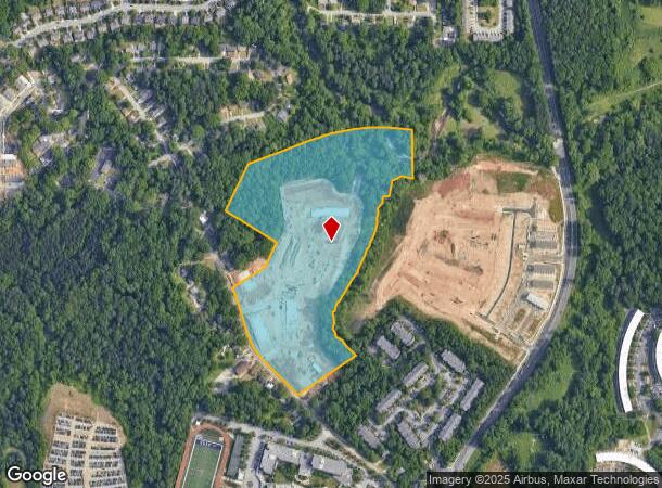
1315 Nw Northwest Dr Nw
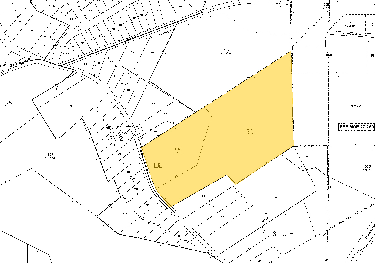
17-0258-LL-132-5
KA POPULUS @ WESTSIDE FLD CK 11/9/22; 35% COMPL ** UPDATE PARCEL/NBHD FROM RES TO COMM DEV AUTH PARCEL ** LAND ONLY VALUE
Apartment
Fulton
AE
Georgia
13121C0236F
22.86 AC
2024
West Atlanta
2023
Atlanta
008602
Atlanta-Sandy Springs-Roswell, GA
354,710 SF
DEMOGRAPHICS near 1315 Nw Northwest Dr Nw
1 Mile
3 Mile
5 Mile
2024 Total Population
5,843
66,593
218,504
2029 Population
6,032
70,183
227,208
Pop Growth 2024-2029
+ 3.23%
+ 5.39%
+ 3.98%
Average Age
34
37
37
2024 Total Households
2,274
27,493
93,277
HH Growth 2024-2029
+ 3.30%
+ 5.41%
+ 4.12%
Median Household Inc
$28,395
$59,759
$71,131
Avg Household Size
2.50
2.30
2.20
2024 Avg HH Vehicles
1.00
1.00
1.00
Median Home Value
$174,173
$307,216
$362,139
Median Year Built
1973
1988
1991
Nearby Places
- Restaurants
- Banks
- Shops
- Fitness
- Groceries
PUBLIC TRANSPORTATION
COMMUTER RAIL
Atlanta (Crescent - Amtrak)
DRIVE
WALK
Distance
Atlanta (Crescent - Amtrak)
16 min
8.9 mi
AIRPORT
Hartsfield - Jackson Atlanta International
DRIVE
WALK
Distance
Hartsfield - Jackson Atlanta International
26 min
16.2 mi
Freight Ports
Georgia Ports - Savannah
DRIVE
WALK
Distance
Georgia Ports - Savannah
289 min
255.5 mi
SALE & LEASE HISTORY
LISTING DATE
SALE/LEASE

Sep 24, 2016
For Sale
Nearby Properties
Address
Land Use
TOTAL SIZE
Lot Size
Zoning
Address
Land Use
TOTAL SIZE
Lot Size
Zoning
695,481 SF
11.66 AC
RG3
Address
Land Use
TOTAL SIZE
Lot Size
Zoning
1,151,446 SF
I2
Address
Land Use
TOTAL SIZE
Lot Size
Zoning
439,167 SF
41.13 AC
RM-12
Address
Land Use
TOTAL SIZE
Lot Size
Zoning
Address
Land Use
TOTAL SIZE
Lot Size
Zoning
467,671 SF
4.82 AC
C1
Address
Land Use
TOTAL SIZE
Lot Size
Zoning
115 AC
I2
Address
Land Use
TOTAL SIZE
Lot Size
Zoning
499,198 SF
9.49 AC
RG3
Address
Land Use
TOTAL SIZE
Lot Size
Zoning
263,676 SF
15.70 AC
RM-12
Address
Land Use
TOTAL SIZE
Lot Size
Zoning
354,766 SF
11.32 AC
RG3
Address
Land Use
TOTAL SIZE
Lot Size
Zoning
3.25 AC
MU
Address
Land Use
TOTAL SIZE
Lot Size
Zoning
59.28 AC
I1
Address
Land Use
TOTAL SIZE
Lot Size
Zoning
285.03 AC
I2
Address
Land Use
TOTAL SIZE
Lot Size
Zoning
19.31 AC
R4
Address
Land Use
TOTAL SIZE
Lot Size
Zoning
694,436 SF
36.80 AC
HI
Address
Land Use
TOTAL SIZE
Lot Size
Zoning
553,853 SF
3.70 AC
RG4
Address
Land Use
TOTAL SIZE
Lot Size
Zoning
68.38 AC
R2
Address
Land Use
TOTAL SIZE
Lot Size
Zoning
190,008 SF
6.97 AC
RG3
Address
Land Use
TOTAL SIZE
Lot Size
Zoning
70,908 SF
9.77 AC
RG3
Address
Land Use
TOTAL SIZE
Lot Size
Zoning
232,710 SF
6.94 AC
I2
Address
Land Use
TOTAL SIZE
Lot Size
Zoning
235,602 SF
17.53 AC
RG3
Address
Land Use
TOTAL SIZE
Lot Size
Zoning
211,506 SF
20.63 AC
CRC
Address
Land Use
TOTAL SIZE
Lot Size
Zoning
77.56 AC
RG3
Address
Land Use
TOTAL SIZE
Lot Size
Zoning
175,630 SF
5.06 AC
RM-12
Address
Land Use
TOTAL SIZE
Lot Size
Zoning
202,430 SF
7.31 AC
C1
Address
Land Use
TOTAL SIZE
Lot Size
Zoning
40,153 SF
5.07 AC
I2
Address
Land Use
TOTAL SIZE
Lot Size
Zoning
167,201 SF
7.32 AC
C1
Address
Land Use
TOTAL SIZE
Lot Size
Zoning
131,299 SF
4.54 AC
C1
Address
Land Use
TOTAL SIZE
Lot Size
Zoning
485,185 SF
3.76 AC
I2
Address
Land Use
TOTAL SIZE
Lot Size
Zoning
85,461 SF
10.62 AC
RG3
The World's #1 Commercial Real Estate Marketplace
Connect with us
© 2025 CoStar Group
The information above has been obtained from sources believed reliable. While we do not doubt its accuracy we have not verified it and make no guarantee, warranty or representation about it. It is your responsibility to independently confirm its accuracy and completeness. Any projections, opinions, assumptions, or estimates used are for example only and do not represent the current or future performance of the property. The value of this transaction to you depends on tax and other factors which should be evaluated by your tax, financial, and legal advisors. You and your advisors should conduct a careful, independent investigation of the property to determine to your satisfaction the suitability of the property for your needs.