Property Record
132 Wessinger Ln, Columbia, SC 29203
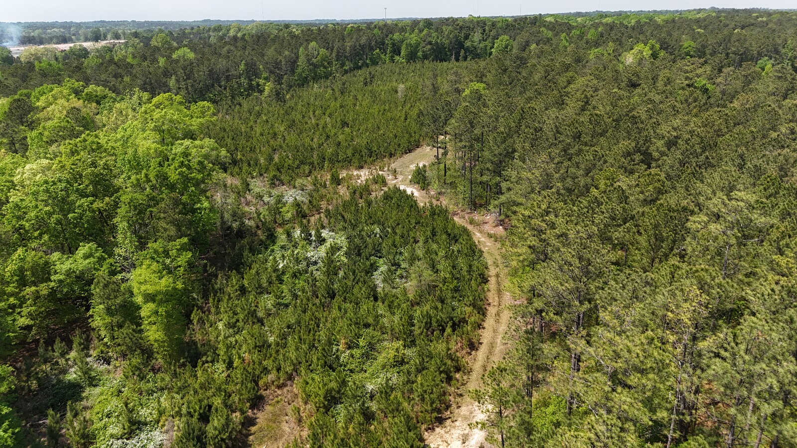
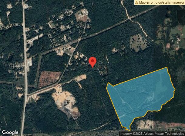
This Property Is For Sale
NEARBY LISTINGS FOR SALE OR LEASE
-
-
View all Columbia listings for sale on LoopNet.com
Property Detail
132 Wessinger Ln
12000-02-06
UNNUMBERED TRACT & PT OF ROAD #SU #PR X-829 Y-829 RB1178-3856
Agriculturalland
Richland
AE
South Carolina
45079C0232L
103.50 AC
2024
North Columbia
2023
Columbia
010200
Columbia, SC
DEMOGRAPHICS near 132 Wessinger Ln
1 Mile
3 Mile
5 Mile
2024 Total Population
896
14,916
76,890
2029 Population
909
15,184
78,443
Pop Growth 2024-2029
+ 1.45%
+ 1.80%
+ 2.02%
Average Age
43
42
39
2024 Total Households
343
5,987
32,584
HH Growth 2024-2029
+ 1.46%
+ 1.77%
+ 2.07%
Median Household Inc
$83,333
$42,014
$43,225
Avg Household Size
2.60
2.40
2.30
2024 Avg HH Vehicles
3.00
2.00
2.00
Median Home Value
$419,182
$126,139
$159,176
Median Year Built
1993
1976
1979
Nearby Places
- Restaurants
- Banks
- Shops
- Fitness
- Groceries
PUBLIC TRANSPORTATION
COMMUTER RAIL
Columbia Amtrak Station (Silver Star - Amtrak)
DRIVE
WALK
Distance
Columbia Amtrak Station (Silver Star - Amtrak)
19 min
9.3 mi
AIRPORT
Columbia Metro
DRIVE
WALK
Distance
Columbia Metro
35 min
19.5 mi
Freight Ports
North Charleston Terminal
DRIVE
WALK
Distance
North Charleston Terminal
135 min
115.8 mi
Nearby Properties
Address
Land Use
TOTAL SIZE
Lot Size
Zoning
Address
Land Use
TOTAL SIZE
Lot Size
Zoning
456,536 SF
42.16 AC
M-1
Address
Land Use
TOTAL SIZE
Lot Size
Zoning
242,894 SF
14.97 AC
RM-HD
Address
Land Use
TOTAL SIZE
Lot Size
Zoning
1,199.74 AC
OI
Address
Land Use
TOTAL SIZE
Lot Size
Zoning
40,992 SF
4.56 AC
M-1
Address
Land Use
TOTAL SIZE
Lot Size
Zoning
115.44 AC
GC
Address
Land Use
TOTAL SIZE
Lot Size
Zoning
10,168 SF
172.52 AC
PDD
Address
Land Use
TOTAL SIZE
Lot Size
Zoning
31,809 SF
6 AC
M-1
Address
Land Use
TOTAL SIZE
Lot Size
Zoning
32,453 SF
5.04 AC
M-1
Address
Land Use
TOTAL SIZE
Lot Size
Zoning
214.32 AC
OI
Address
Land Use
TOTAL SIZE
Lot Size
Zoning
12,000 SF
8.47 AC
M-1
Address
Land Use
TOTAL SIZE
Lot Size
Zoning
245.08 AC
PDD
Address
Land Use
TOTAL SIZE
Lot Size
Zoning
48,750 SF
4.46 AC
M-1
Address
Land Use
TOTAL SIZE
Lot Size
Zoning
50,850 SF
4.98 AC
M-1
Address
Land Use
TOTAL SIZE
Lot Size
Zoning
21,710 SF
4 AC
M-1
Address
Land Use
TOTAL SIZE
Lot Size
Zoning
7,348 SF
1.08 AC
OI
Address
Land Use
TOTAL SIZE
Lot Size
Zoning
2,872 SF
1.19 AC
C-3
Address
Land Use
TOTAL SIZE
Lot Size
Zoning
30,400 SF
6.01 AC
C-3
Address
Land Use
TOTAL SIZE
Lot Size
Zoning
69.49 AC
OI
Address
Land Use
TOTAL SIZE
Lot Size
Zoning
52,134 SF
7.21 AC
M-1
Address
Land Use
TOTAL SIZE
Lot Size
Zoning
34,500 SF
2.01 AC
M-1
Address
Land Use
TOTAL SIZE
Lot Size
Zoning
13,040 SF
5.39 AC
RU
Address
Land Use
TOTAL SIZE
Lot Size
Zoning
12,996 SF
4.91 AC
M-1
Address
Land Use
TOTAL SIZE
Lot Size
Zoning
9,870 SF
1.90 AC
GC
Address
Land Use
TOTAL SIZE
Lot Size
Zoning
48,289 SF
5.90 AC
D-1
Address
Land Use
TOTAL SIZE
Lot Size
Zoning
16,500 SF
7.21 AC
HI
Address
Land Use
TOTAL SIZE
Lot Size
Zoning
22,256 SF
1.70 AC
M-1
Address
Land Use
TOTAL SIZE
Lot Size
Zoning
55,013 SF
5.33 AC
C-3
Address
Land Use
TOTAL SIZE
Lot Size
Zoning
39,041 SF
4.12 AC
M-1
Address
Land Use
TOTAL SIZE
Lot Size
Zoning
16.26 AC
M-1
Address
Land Use
TOTAL SIZE
Lot Size
Zoning
8,280 SF
6.70 AC
C-3
The World's #1 Commercial Real Estate Marketplace
Connect with us
© 2025 CoStar Group
The information above has been obtained from sources believed reliable. While we do not doubt its accuracy we have not verified it and make no guarantee, warranty or representation about it. It is your responsibility to independently confirm its accuracy and completeness. Any projections, opinions, assumptions, or estimates used are for example only and do not represent the current or future performance of the property. The value of this transaction to you depends on tax and other factors which should be evaluated by your tax, financial, and legal advisors. You and your advisors should conduct a careful, independent investigation of the property to determine to your satisfaction the suitability of the property for your needs.