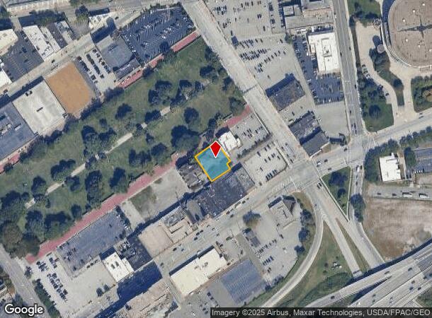
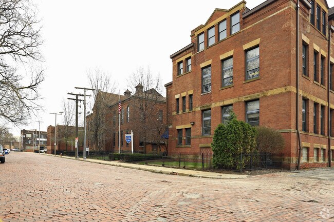
Property Record
1320 Sumner Ave, Cleveland, OH 44115

Current Lease Availabilities
NEARBY LISTINGS FOR SALE OR LEASE
Property Detail
1320 Sumner Ave
Cleveland-Elyria, OH
Brownell Sub
101-38-051
141 BROWNELL SUBD 0002
Officebuilding
Cuyahoga
X
Ohio
39035C0181F
2
2024
0.30 AC
2024
CBD
107701
Cleveland
19,261 SF
DEMOGRAPHICS near 1320 Sumner Ave
1 Mile
3 Mile
5 Mile
2024 Total Population
17,776
84,753
250,554
2029 Population
18,083
83,776
245,914
Pop Growth 2024-2029
+ 1.73%
(1.15%)
(1.85%)
Average Age
33
37
38
2024 Total Households
9,952
41,028
115,974
HH Growth 2024-2029
+ 2.75%
(0.81%)
(1.74%)
Median Household Inc
$47,639
$35,786
$34,506
Avg Household Size
1.50
1.90
2.00
2024 Avg HH Vehicles
1.00
1.00
1.00
Median Home Value
$188,845
$143,238
$90,416
Median Year Built
1970
1948
1947
Nearby Places
- Restaurants
- Banks
- Shops
- Fitness
- Groceries
PUBLIC TRANSPORTATION
TRANSIT/SUBWAY
Tower City Station Track 13 (Blue/Green) (Blue/Green/Waterfront Lines - Greater Cleveland Regional Transit Authority)
DRIVE
WALK
Distance
Tower City Station Track 13 (Blue/Green) (Blue/Green/Waterfront Lines - Greater Cleveland Regional Transit Authority)
2 min
16 min
0.9 mi
Tower City Station Track 10 West (Red Line - Greater Cleveland Regional Transit Authority)
DRIVE
WALK
Distance
Tower City Station Track 10 West (Red Line - Greater Cleveland Regional Transit Authority)
2 min
17 min
0.9 mi
Tower City - Public Square (Blue Line - Greater Cleveland Regional Transit Authority Rapid Transit (The Rapid), Green Line - Greater Cleveland Regional Transit Authority Rapid Transit (The Rapid), Red Line - Greater Cleveland Regional Transit Authority Rapid Transit (The Rapid))
DRIVE
WALK
Distance
Tower City - Public Square (Blue Line - Greater Cleveland Regional Transit Authority Rapid Transit (The Rapid), Green Line - Greater Cleveland Regional Transit Authority Rapid Transit (The Rapid), Red Line - Greater Cleveland Regional Transit Authority Rapid Transit (The Rapid))
2 min
17 min
0.9 mi
COMMUTER RAIL
Cleveland Lakefront Station (Blue Line - Greater Cleveland Regional Transit Authority Rapid Transit (The Rapid), Green Line - Greater Cleveland Regional Transit Authority Rapid Transit (The Rapid))
DRIVE
WALK
Distance
Cleveland Lakefront Station (Blue Line - Greater Cleveland Regional Transit Authority Rapid Transit (The Rapid), Green Line - Greater Cleveland Regional Transit Authority Rapid Transit (The Rapid))
8 min
2.4 mi
Rockside (National Park Scenic Railway - Cuyahoga Valley Scenic Railroad)
DRIVE
WALK
Distance
Rockside (National Park Scenic Railway - Cuyahoga Valley Scenic Railroad)
15 min
8.9 mi
AIRPORT
Cleveland-Hopkins International
DRIVE
WALK
Distance
Cleveland-Hopkins International
21 min
13.3 mi
Freight Ports
Port of Toledo
DRIVE
WALK
Distance
Port of Toledo
135 min
113.7 mi
Nearby Properties
Address
Land Use
TOTAL SIZE
Lot Size
Zoning
Address
Land Use
TOTAL SIZE
Lot Size
Zoning
1,211,519 SF
13.57 AC
GR
Address
Land Use
TOTAL SIZE
Lot Size
Zoning
3,491,901 SF
34.32 AC
Address
Land Use
TOTAL SIZE
Lot Size
Zoning
753,970 SF
9.31 AC
GR
Address
Land Use
TOTAL SIZE
Lot Size
Zoning
1,570,958 SF
1.33 AC
GR
Address
Land Use
TOTAL SIZE
Lot Size
Zoning
17.45 AC
GI
Address
Land Use
TOTAL SIZE
Lot Size
Zoning
16.78 AC
SI
Address
Land Use
TOTAL SIZE
Lot Size
Zoning
710,780 SF
4.33 AC
GR
Address
Land Use
TOTAL SIZE
Lot Size
Zoning
765,607 SF
12.15 AC
GR
Address
Land Use
TOTAL SIZE
Lot Size
Zoning
788,580 SF
4.85 AC
GR
Address
Land Use
TOTAL SIZE
Lot Size
Zoning
1,227,793 SF
6.80 AC
GR
Address
Land Use
TOTAL SIZE
Lot Size
Zoning
434,475 SF
0.53 AC
Address
Land Use
TOTAL SIZE
Lot Size
Zoning
1,191,268 SF
3.94 AC
SI
Address
Land Use
TOTAL SIZE
Lot Size
Zoning
6.98 AC
SI
Address
Land Use
TOTAL SIZE
Lot Size
Zoning
148,486 SF
489.21 AC
GI
Address
Land Use
TOTAL SIZE
Lot Size
Zoning
5,100 SF
9.41 AC
GI
Address
Land Use
TOTAL SIZE
Lot Size
Zoning
652,455 SF
2.04 AC
GR
Address
Land Use
TOTAL SIZE
Lot Size
Zoning
263,723 SF
7.48 AC
GI
Address
Land Use
TOTAL SIZE
Lot Size
Zoning
1,130,924 SF
4.02 AC
SI
Address
Land Use
TOTAL SIZE
Lot Size
Zoning
299,515 SF
1.30 AC
GR
Address
Land Use
TOTAL SIZE
Lot Size
Zoning
1,181,536 SF
27.82 AC
RO
Address
Land Use
TOTAL SIZE
Lot Size
Zoning
228,154 SF
0.48 AC
GR
Address
Land Use
TOTAL SIZE
Lot Size
Zoning
3.23 AC
LLR
Address
Land Use
TOTAL SIZE
Lot Size
Zoning
2.74 AC
Address
Land Use
TOTAL SIZE
Lot Size
Zoning
1,003,787 SF
2.12 AC
GR
Address
Land Use
TOTAL SIZE
Lot Size
Zoning
1,467,599 SF
1.66 AC
GR
Address
Land Use
TOTAL SIZE
Lot Size
Zoning
758,394 SF
2.24 AC
GR
Address
Land Use
TOTAL SIZE
Lot Size
Zoning
493,911 SF
1.88 AC
LLR
Address
Land Use
TOTAL SIZE
Lot Size
Zoning
257,857 SF
8.02 AC
GR
Address
Land Use
TOTAL SIZE
Lot Size
Zoning
1.53 AC
LLR
Address
Land Use
TOTAL SIZE
Lot Size
Zoning
299,507 SF
2.14 AC
LR
The World's #1 Commercial Real Estate Marketplace
Connect with us
© 2025 CoStar Group
The information above has been obtained from sources believed reliable. While we do not doubt its accuracy we have not verified it and make no guarantee, warranty or representation about it. It is your responsibility to independently confirm its accuracy and completeness. Any projections, opinions, assumptions, or estimates used are for example only and do not represent the current or future performance of the property. The value of this transaction to you depends on tax and other factors which should be evaluated by your tax, financial, and legal advisors. You and your advisors should conduct a careful, independent investigation of the property to determine to your satisfaction the suitability of the property for your needs.