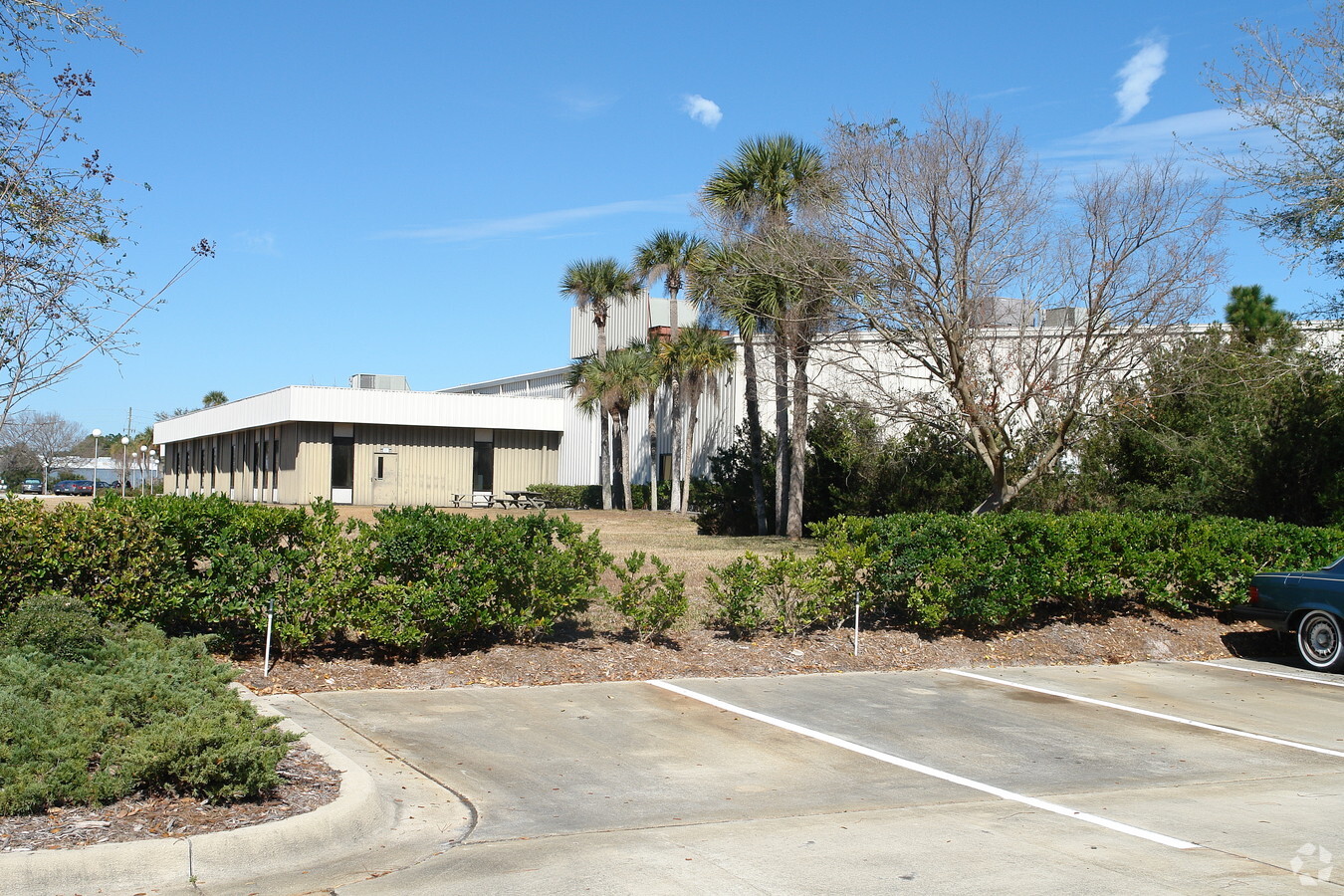
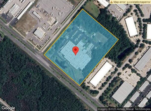
Property Record
1327 N Us Highway 1, Ormond Beach, FL 32174


NEARBY LISTINGS FOR SALE OR LEASE
-
-
-
Se Corner of Pineland Trail & N. Tymber Creek Rd
Ormond Beach, FL 32174
Negotiable
211,680 SF
Industrial
-
View all Ormond Beach listings for sale on LoopNet.com
Property Detail
1327 N Us Highway 1
3231-00-00-0061
6 14 32 & 31 13 32 PART OF LOT 2 IN 6 14 32 & PART OF S 1/2 OF SW 1/4 IN 31 13 32 BEING N 660 FT MEAS ON US 1 S OF SOUTH PER OR 8052 PG 3494 PER OR 8209 PG 0967 PER OR 8226 PG 1635
Lightindustrial
Volusia
X
Florida
12127C0203K
2
2023
12.50 AC
2024
Ormond Beach
080101
Deltona/Daytona Beach
102,465 SF
Deltona-Daytona Beach-Ormond Beach, FL
DEMOGRAPHICS near 1327 N Us Highway 1
1 Mile
3 Mile
5 Mile
2024 Total Population
2,798
10,323
56,100
2029 Population
3,102
11,387
62,938
Pop Growth 2024-2029
+ 10.86%
+ 10.31%
+ 12.19%
Average Age
49
49
50
2024 Total Households
1,180
4,500
25,781
HH Growth 2024-2029
+ 11.02%
+ 10.49%
+ 12.47%
Median Household Inc
$71,490
$71,685
$63,991
Avg Household Size
2.30
2.30
2.10
2024 Avg HH Vehicles
2.00
2.00
2.00
Median Home Value
$306,392
$290,277
$292,365
Median Year Built
1993
1986
1984
Nearby Places
- Restaurants
- Banks
- Shops
- Fitness
- Groceries
PUBLIC TRANSPORTATION
AIRPORT
Daytona Beach International
DRIVE
WALK
Distance
Daytona Beach International
23 min
15.9 mi
Freight Ports
Port Canaveral
DRIVE
WALK
Distance
Port Canaveral
96 min
83.1 mi
Nearby Properties
Address
Land Use
TOTAL SIZE
Lot Size
Zoning
Address
Land Use
TOTAL SIZE
Lot Size
Zoning
13,846 SF
126.83 AC
13T1
Address
Land Use
TOTAL SIZE
Lot Size
Zoning
137,934 SF
48.30 AC
Address
Land Use
TOTAL SIZE
Lot Size
Zoning
768 SF
2,212.55 AC
C
Address
Land Use
TOTAL SIZE
Lot Size
Zoning
5,350 SF
36.42 AC
13T1
Address
Land Use
TOTAL SIZE
Lot Size
Zoning
2,519.40 AC
Address
Land Use
TOTAL SIZE
Lot Size
Zoning
161,123 SF
13.56 AC
I1
Address
Land Use
TOTAL SIZE
Lot Size
Zoning
196,932 SF
12.44 AC
BPUD
Address
Land Use
TOTAL SIZE
Lot Size
Zoning
209,984 SF
24.14 AC
I1
Address
Land Use
TOTAL SIZE
Lot Size
Zoning
87,633 SF
568.96 AC
RR
Address
Land Use
TOTAL SIZE
Lot Size
Zoning
96,309 SF
29.04 AC
Address
Land Use
TOTAL SIZE
Lot Size
Zoning
106,488 SF
27.60 AC
MPUD
Address
Land Use
TOTAL SIZE
Lot Size
Zoning
173,757 SF
11.64 AC
Address
Land Use
TOTAL SIZE
Lot Size
Zoning
180,677 SF
12.31 AC
13I1
Address
Land Use
TOTAL SIZE
Lot Size
Zoning
255.79 AC
RPUD
Address
Land Use
TOTAL SIZE
Lot Size
Zoning
13,724 SF
219.03 AC
RPUD
Address
Land Use
TOTAL SIZE
Lot Size
Zoning
181,481 SF
8.76 AC
13I1
Address
Land Use
TOTAL SIZE
Lot Size
Zoning
17,631 SF
5.47 AC
A2
Address
Land Use
TOTAL SIZE
Lot Size
Zoning
20,986 SF
796 AC
RC
Address
Land Use
TOTAL SIZE
Lot Size
Zoning
16,887 SF
9.09 AC
01I1
Address
Land Use
TOTAL SIZE
Lot Size
Zoning
147,329 SF
11.50 AC
13I1
Address
Land Use
TOTAL SIZE
Lot Size
Zoning
31,277 SF
5.45 AC
BPUD
Address
Land Use
TOTAL SIZE
Lot Size
Zoning
57,230 SF
6.85 AC
01B6
Address
Land Use
TOTAL SIZE
Lot Size
Zoning
41,746 SF
3.28 AC
Address
Land Use
TOTAL SIZE
Lot Size
Zoning
30,364 SF
6 AC
13B1
Address
Land Use
TOTAL SIZE
Lot Size
Zoning
151,185 SF
28.90 AC
01I1
Address
Land Use
TOTAL SIZE
Lot Size
Zoning
43 AC
R2
Address
Land Use
TOTAL SIZE
Lot Size
Zoning
123 AC
RPUD
Address
Land Use
TOTAL SIZE
Lot Size
Zoning
48,646 SF
3.05 AC
B6
Address
Land Use
TOTAL SIZE
Lot Size
Zoning
47,750 SF
7.08 AC
The World's #1 Commercial Real Estate Marketplace
Connect with us
© 2025 CoStar Group
The information above has been obtained from sources believed reliable. While we do not doubt its accuracy we have not verified it and make no guarantee, warranty or representation about it. It is your responsibility to independently confirm its accuracy and completeness. Any projections, opinions, assumptions, or estimates used are for example only and do not represent the current or future performance of the property. The value of this transaction to you depends on tax and other factors which should be evaluated by your tax, financial, and legal advisors. You and your advisors should conduct a careful, independent investigation of the property to determine to your satisfaction the suitability of the property for your needs.