Property Record
13390 Clarksville Pike, Highland, MD 20777
NEARBY LISTINGS FOR SALE OR LEASE
Property Detail
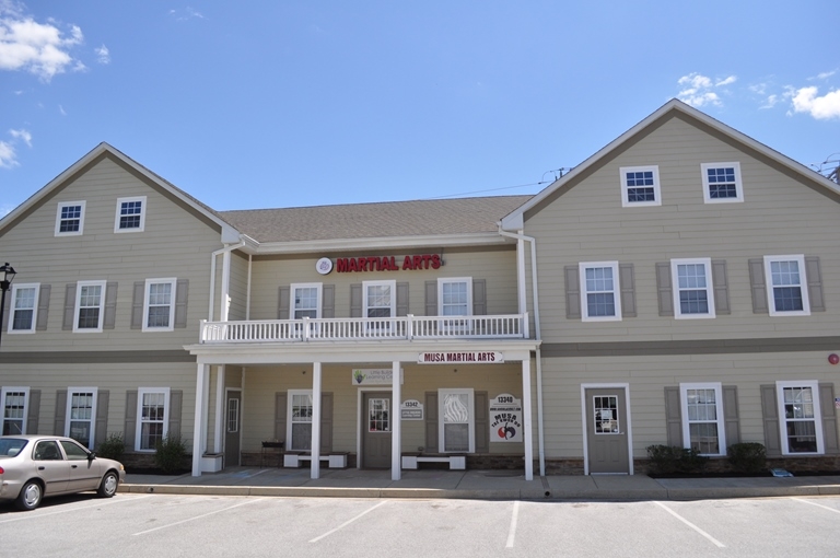
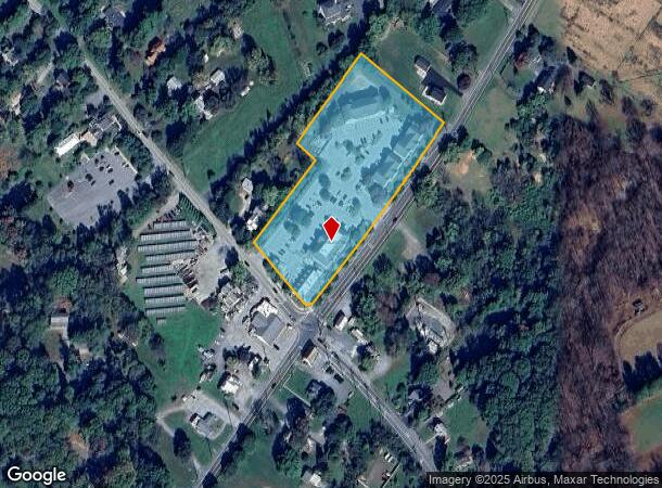
13390 Clarksville Pike
05-450381
Highland Crossing Condominium
Officecondo
P/O A P/O 7461 SQ 13390 CLARKSVILLE PIKE HIGHLAND CROSSING CONDO
X
Howard
24027C0140D
Maryland
2024
0.17 AC
2024
Outlying Howard County
605103
Baltimore
2,168 SF
Baltimore-Columbia-Towson, MD
DEMOGRAPHICS near 13390 Clarksville Pike
1 Mile
3 Mile
5 Mile
2024 Total Population
1,575
20,622
76,215
2029 Population
1,614
21,104
77,897
Pop Growth 2024-2029
+ 2.48%
+ 2.34%
+ 2.21%
Average Age
43
41
41
2024 Total Households
493
6,420
26,163
HH Growth 2024-2029
+ 2.64%
+ 2.29%
+ 2.27%
Median Household Inc
$190,295
$211,176
$158,794
Avg Household Size
3.10
3.20
2.80
2024 Avg HH Vehicles
3.00
3.00
2.00
Median Home Value
$806,428
$781,760
$699,168
Median Year Built
1987
1995
1987
Nearby Places
- Restaurants
- Banks
- Shops
- Fitness
- Groceries
PUBLIC TRANSPORTATION
COMMUTER RAIL
Laurel (Camden Line - Maryland Area Regional Commuter Trains (The MARC))
DRIVE
WALK
Distance
Laurel (Camden Line - Maryland Area Regional Commuter Trains (The MARC))
16 min
9.1 mi
AIRPORT
Baltimore/Washington International Thurgood Marshall
DRIVE
WALK
Distance
Baltimore/Washington International Thurgood Marshall
32 min
22.3 mi
Ronald Reagan Washington Ntl
DRIVE
WALK
Distance
Ronald Reagan Washington Ntl
48 min
28.4 mi
Freight Ports
Port of Baltimore
DRIVE
WALK
Distance
Port of Baltimore
36 min
25.2 mi
SALE & LEASE HISTORY
LISTING DATE
SALE/LEASE

Sep 26, 2017
For Lease
Sep 25, 2016
For Lease
Jan 31, 2018
For Lease
Feb 10, 2023
For Lease
Nearby Properties
Address
Land Use
TOTAL SIZE
Lot Size
Zoning
Address
Land Use
TOTAL SIZE
Lot Size
Zoning
89,320 SF
101.22 AC
RRMXD
Address
Land Use
TOTAL SIZE
Lot Size
Zoning
34,368 SF
54.80 AC
PEC
Address
Land Use
TOTAL SIZE
Lot Size
Zoning
19,253 SF
17.97 AC
RRDEO
Address
Land Use
TOTAL SIZE
Lot Size
Zoning
6,968 SF
11.74 AC
NT
Address
Land Use
TOTAL SIZE
Lot Size
Zoning
86,143 SF
3.53 AC
MXD3
Address
Land Use
TOTAL SIZE
Lot Size
Zoning
82,960 SF
15.40 AC
NT
Address
Land Use
TOTAL SIZE
Lot Size
Zoning
172.63 AC
RRDEO
Address
Land Use
TOTAL SIZE
Lot Size
Zoning
1,056 SF
20.99 AC
RRDEO
Address
Land Use
TOTAL SIZE
Lot Size
Zoning
3,260 SF
8.78 AC
B2
Address
Land Use
TOTAL SIZE
Lot Size
Zoning
27,564 SF
7.60 AC
B1
Address
Land Use
TOTAL SIZE
Lot Size
Zoning
39,008 SF
7.01 AC
B2
Address
Land Use
TOTAL SIZE
Lot Size
Zoning
13,272 SF
3.33 AC
B2
Address
Land Use
TOTAL SIZE
Lot Size
Zoning
11,530 SF
5.89 AC
B2
Address
Land Use
TOTAL SIZE
Lot Size
Zoning
2,110 SF
5.44 AC
B1
Address
Land Use
TOTAL SIZE
Lot Size
Zoning
38,067 SF
0.76 AC
MXD3
Address
Land Use
TOTAL SIZE
Lot Size
Zoning
12,721 SF
1.29 AC
B1
Address
Land Use
TOTAL SIZE
Lot Size
Zoning
26,160 SF
1.74 AC
NT
Address
Land Use
TOTAL SIZE
Lot Size
Zoning
29,560 SF
3.79 AC
B2
Address
Land Use
TOTAL SIZE
Lot Size
Zoning
26,610 SF
3 AC
B2
Address
Land Use
TOTAL SIZE
Lot Size
Zoning
13.56 AC
B2PEC
Address
Land Use
TOTAL SIZE
Lot Size
Zoning
40,000 SF
3.08 AC
B2
Address
Land Use
TOTAL SIZE
Lot Size
Zoning
27,927 SF
3.42 AC
B2
Address
Land Use
TOTAL SIZE
Lot Size
Zoning
16,975 SF
3.58 AC
B2
Address
Land Use
TOTAL SIZE
Lot Size
Zoning
35,802 SF
17.50 AC
RRDEO
Address
Land Use
TOTAL SIZE
Lot Size
Zoning
2,970 SF
3.48 AC
B2
Address
Land Use
TOTAL SIZE
Lot Size
Zoning
3,206 SF
1.30 AC
NT
Address
Land Use
TOTAL SIZE
Lot Size
Zoning
17,846 SF
1.95 AC
B2
Address
Land Use
TOTAL SIZE
Lot Size
Zoning
26,464 SF
1.79 AC
NT
Address
Land Use
TOTAL SIZE
Lot Size
Zoning
15,570 SF
2.49 AC
B2
Address
Land Use
TOTAL SIZE
Lot Size
Zoning
17,838 SF
3.02 AC
RRDEO
The World's #1 Commercial Real Estate Marketplace
Connect with us
© 2025 CoStar Group
The information above has been obtained from sources believed reliable. While we do not doubt its accuracy we have not verified it and make no guarantee, warranty or representation about it. It is your responsibility to independently confirm its accuracy and completeness. Any projections, opinions, assumptions, or estimates used are for example only and do not represent the current or future performance of the property. The value of this transaction to you depends on tax and other factors which should be evaluated by your tax, financial, and legal advisors. You and your advisors should conduct a careful, independent investigation of the property to determine to your satisfaction the suitability of the property for your needs.