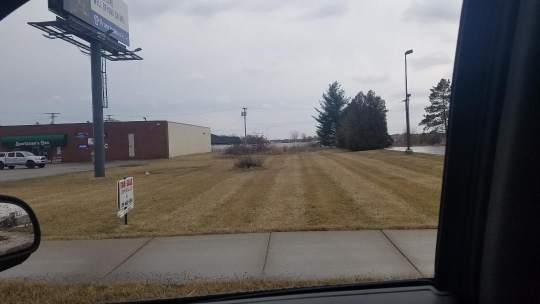
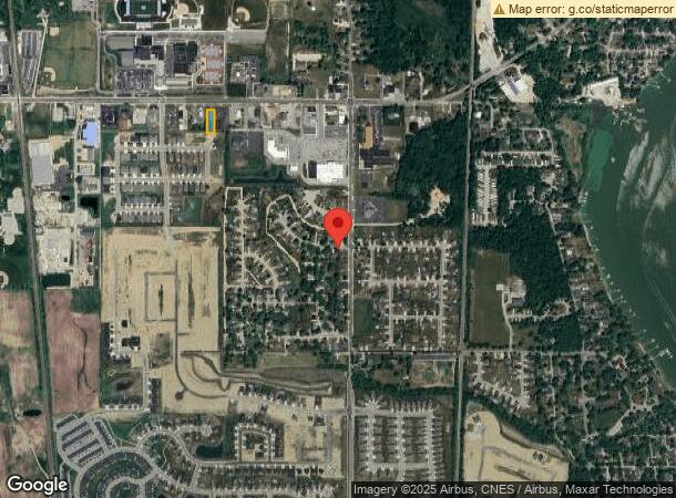
Property Record
133Rd Ave, Cedar Lake, IN 46303
NEARBY LISTINGS FOR SALE OR LEASE
Property Detail
133Rd Ave
Chicago-Naperville-Elgin, IL-IN-WI
Airport Heights
45-15-28-202-005.000-014
AIRPORT HEIGHTS WEST 80FT. OF LOT 11
Commercialacreage
Lake
X
Indiana
18089C0239E
11
2023
0.46 AC
2024
Indiana
042901
Chicago
DEMOGRAPHICS near 133Rd Ave
1 Mile
3 Mile
5 Mile
2024 Total Population
5,657
19,877
46,764
2029 Population
5,865
20,454
47,702
Pop Growth 2024-2029
+ 3.68%
+ 2.90%
+ 2.01%
Average Age
41
40
41
2024 Total Households
2,189
7,532
17,198
HH Growth 2024-2029
+ 3.70%
+ 2.99%
+ 2.07%
Median Household Inc
$79,155
$77,095
$95,796
Avg Household Size
2.60
2.60
2.70
2024 Avg HH Vehicles
2.00
2.00
2.00
Median Home Value
$262,863
$263,536
$296,256
Median Year Built
2002
1996
1999
Nearby Places
- Restaurants
- Banks
- Shops
- Fitness
- Groceries
SALE & LEASE HISTORY
LISTING DATE
SALE/LEASE

Sep 25, 2016
For Lease
Sep 24, 2020
For Sale
Sep 24, 2016
For Sale
Nearby Properties
Address
Land Use
TOTAL SIZE
Lot Size
Zoning
Address
Land Use
TOTAL SIZE
Lot Size
Zoning
65,700 SF
18.74 AC
Address
Land Use
TOTAL SIZE
Lot Size
Zoning
49,680 SF
8.19 AC
Address
Land Use
TOTAL SIZE
Lot Size
Zoning
34,325 SF
7.90 AC
Address
Land Use
TOTAL SIZE
Lot Size
Zoning
27,884 SF
4.97 AC
Address
Land Use
TOTAL SIZE
Lot Size
Zoning
28,080 SF
12.77 AC
Address
Land Use
TOTAL SIZE
Lot Size
Zoning
75,440 SF
25.47 AC
Address
Land Use
TOTAL SIZE
Lot Size
Zoning
49,902 SF
4.17 AC
Address
Land Use
TOTAL SIZE
Lot Size
Zoning
39,410 SF
3.16 AC
Address
Land Use
TOTAL SIZE
Lot Size
Zoning
23,421 SF
4.06 AC
R33
Address
Land Use
TOTAL SIZE
Lot Size
Zoning
40,764 SF
2.34 AC
Address
Land Use
TOTAL SIZE
Lot Size
Zoning
15,296 SF
7.11 AC
Address
Land Use
TOTAL SIZE
Lot Size
Zoning
42,444 SF
11.26 AC
Address
Land Use
TOTAL SIZE
Lot Size
Zoning
3,472 SF
1.94 AC
Address
Land Use
TOTAL SIZE
Lot Size
Zoning
88,500 SF
6.68 AC
Address
Land Use
TOTAL SIZE
Lot Size
Zoning
40,132 SF
4.21 AC
Address
Land Use
TOTAL SIZE
Lot Size
Zoning
15,284 SF
2.19 AC
Address
Land Use
TOTAL SIZE
Lot Size
Zoning
13,835 SF
1.46 AC
Address
Land Use
TOTAL SIZE
Lot Size
Zoning
42,476 SF
20.04 AC
Address
Land Use
TOTAL SIZE
Lot Size
Zoning
15,837 SF
1.76 AC
Address
Land Use
TOTAL SIZE
Lot Size
Zoning
36,272 SF
3.61 AC
R33
Address
Land Use
TOTAL SIZE
Lot Size
Zoning
28,220 SF
2.06 AC
R3
Address
Land Use
TOTAL SIZE
Lot Size
Zoning
4,091 SF
1.15 AC
Address
Land Use
TOTAL SIZE
Lot Size
Zoning
16,831 SF
21.23 AC
Address
Land Use
TOTAL SIZE
Lot Size
Zoning
9,984 SF
0.62 AC
Address
Land Use
TOTAL SIZE
Lot Size
Zoning
11,224 SF
18.84 AC
R3
Address
Land Use
TOTAL SIZE
Lot Size
Zoning
24,516 SF
61.41 AC
Address
Land Use
TOTAL SIZE
Lot Size
Zoning
7,978 SF
4.06 AC
Address
Land Use
TOTAL SIZE
Lot Size
Zoning
8,701 SF
335.09 AC
Address
Land Use
TOTAL SIZE
Lot Size
Zoning
6,786 SF
32.50 AC
Address
Land Use
TOTAL SIZE
Lot Size
Zoning
8,740 SF
2.72 AC
The World's #1 Commercial Real Estate Marketplace
Connect with us
© 2025 CoStar Group
The information above has been obtained from sources believed reliable. While we do not doubt its accuracy we have not verified it and make no guarantee, warranty or representation about it. It is your responsibility to independently confirm its accuracy and completeness. Any projections, opinions, assumptions, or estimates used are for example only and do not represent the current or future performance of the property. The value of this transaction to you depends on tax and other factors which should be evaluated by your tax, financial, and legal advisors. You and your advisors should conduct a careful, independent investigation of the property to determine to your satisfaction the suitability of the property for your needs.