Property Record
13435 S Mccall Rd, Port Charlotte, FL 33981
NEARBY LISTINGS FOR SALE OR LEASE
Property Detail
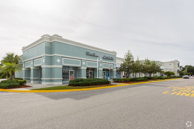
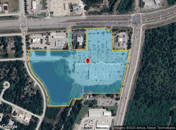
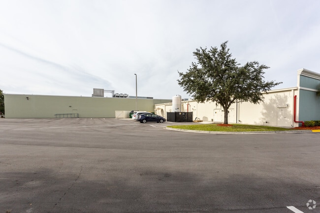
13435 S Mccall Rd
412105481001
Publix At Gulf Cove P-5
Regionalshoppingcenterormallwithanchorstore
PUBLIX AT GULF COVE P-5 16.295 AC. E1991/1257 E1991/1265 MOL2036/1307 E3339/442 UNREC DOC
AE
Charlotte
12015C0211G
Florida
2024
16.30 AC
2025
Charlotte County
030102
Southwest Florida
71,494 SF
Punta Gorda, FL
DEMOGRAPHICS near 13435 S Mccall Rd
1 Mile
3 Mile
5 Mile
2024 Total Population
2,730
18,961
44,442
2029 Population
3,324
23,059
54,009
Pop Growth 2024-2029
+ 21.76%
+ 21.61%
+ 21.53%
Average Age
53
54
55
2024 Total Households
1,280
8,699
20,677
HH Growth 2024-2029
+ 21.88%
+ 21.77%
+ 21.71%
Median Household Inc
$61,345
$63,080
$63,366
Avg Household Size
2.10
2.20
2.10
2024 Avg HH Vehicles
2.00
2.00
2.00
Median Home Value
$248,033
$285,486
$290,093
Median Year Built
1988
1998
1999
Nearby Places
Map Layers
Map Styles
 Street
 Aerial
- Restaurants
- Banks
- Shops
- Fitness
- Groceries
PUBLIC TRANSPORTATION
AIRPORT
Punta Gorda
DRIVE
WALK
Distance
Punta Gorda
36 min
20.7 mi
Freight Ports
Port Manatee
DRIVE
WALK
Distance
Port Manatee
85 min
62.4 mi
SALE & LEASE HISTORY
LISTING DATE
SALE/LEASE

Sep 24, 2016
For Lease
May 15, 2019
For Lease
Jun 09, 2017
For Lease
Nearby Properties
Address
Land Use
TOTAL SIZE
Lot Size
Zoning
Address
Land Use
TOTAL SIZE
Lot Size
Zoning
99,840 SF
7.60 AC
IG
Address
Land Use
TOTAL SIZE
Lot Size
Zoning
27.65 AC
RMF15
Address
Land Use
TOTAL SIZE
Lot Size
Zoning
108,048 SF
14.84 AC
CG
Address
Land Use
TOTAL SIZE
Lot Size
Zoning
132.79 AC
PKR
Address
Land Use
TOTAL SIZE
Lot Size
Zoning
2,016 SF
315.56 AC
PD
Address
Land Use
TOTAL SIZE
Lot Size
Zoning
51,683 SF
7.16 AC
CG
Address
Land Use
TOTAL SIZE
Lot Size
Zoning
100,910 SF
22.85 AC
RSF3.5
Address
Land Use
TOTAL SIZE
Lot Size
Zoning
34.11 AC
CG
Address
Land Use
TOTAL SIZE
Lot Size
Zoning
20.12 AC
CG
Address
Land Use
TOTAL SIZE
Lot Size
Zoning
38.14 AC
IG
Address
Land Use
TOTAL SIZE
Lot Size
Zoning
6,055 SF
2.74 AC
RMF15
Address
Land Use
TOTAL SIZE
Lot Size
Zoning
12,300 SF
5.02 AC
IG
Address
Land Use
TOTAL SIZE
Lot Size
Zoning
11,509 SF
12.06 AC
RSF3.5
Address
Land Use
TOTAL SIZE
Lot Size
Zoning
0.20 AC
RSF3.5
Address
Land Use
TOTAL SIZE
Lot Size
Zoning
560 SF
10.23 AC
IG
Address
Land Use
TOTAL SIZE
Lot Size
Zoning
16.53 AC
CG
Address
Land Use
TOTAL SIZE
Lot Size
Zoning
8,510 SF
2.25 AC
CG
Address
Land Use
TOTAL SIZE
Lot Size
Zoning
5,222 SF
85.60 AC
RMF10
Address
Land Use
TOTAL SIZE
Lot Size
Zoning
3,864 SF
2 AC
CG
Address
Land Use
TOTAL SIZE
Lot Size
Zoning
12,907 SF
165.69 AC
RSF5
Address
Land Use
TOTAL SIZE
Lot Size
Zoning
18,599 SF
1.96 AC
IG
Address
Land Use
TOTAL SIZE
Lot Size
Zoning
10.88 AC
CG
Address
Land Use
TOTAL SIZE
Lot Size
Zoning
11,708 SF
9.99 AC
II
Address
Land Use
TOTAL SIZE
Lot Size
Zoning
3,767 SF
88.50 AC
RSF2
Address
Land Use
TOTAL SIZE
Lot Size
Zoning
4,000 SF
7.78 AC
RMF10
Address
Land Use
TOTAL SIZE
Lot Size
Zoning
3,589 SF
1.47 AC
CG
Address
Land Use
TOTAL SIZE
Lot Size
Zoning
3,112 SF
1.27 AC
CG
Address
Land Use
TOTAL SIZE
Lot Size
Zoning
7,699 SF
1.26 AC
CG
The World's #1 Commercial Real Estate Marketplace
Connect with us
© 2026 CoStar Group
The information above has been obtained from sources believed reliable. While we do not doubt its accuracy we have not verified it and make no guarantee, warranty or representation about it. It is your responsibility to independently confirm its accuracy and completeness. Any projections, opinions, assumptions, or estimates used are for example only and do not represent the current or future performance of the property. The value of this transaction to you depends on tax and other factors which should be evaluated by your tax, financial, and legal advisors. You and your advisors should conduct a careful, independent investigation of the property to determine to your satisfaction the suitability of the property for your needs.