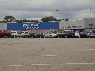
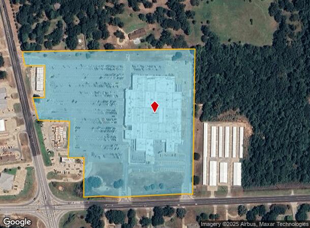
Property Record
135 Ne Loop 564, Mineola, TX 75773
NEARBY LISTINGS FOR SALE OR LEASE
Property Detail
135 Ne Loop 564
R16321
Hamilton A
Commercialnec
ABS 0285; HAMILTON A; TRACT 5 PT; 19.194 ACRES
X
Wood
48499C0330C
Texas
2023
19.19 AC
2023
Texas East Area
950700
Other Market Areas
151,440 SF
DEMOGRAPHICS near 135 Ne Loop 564
1 Mile
3 Mile
5 Mile
2024 Total Population
2,015
8,967
11,650
2029 Population
2,259
10,032
12,987
Pop Growth 2024-2029
+ 12.11%
+ 11.88%
+ 11.48%
Average Age
47
43
44
2024 Total Households
839
3,506
4,560
HH Growth 2024-2029
+ 12.40%
+ 11.95%
+ 11.56%
Median Household Inc
$42,631
$49,209
$51,991
Avg Household Size
2.20
2.40
2.50
2024 Avg HH Vehicles
2.00
2.00
2.00
Median Home Value
$156,470
$143,956
$158,196
Median Year Built
1991
1988
1989
Nearby Places
- Restaurants
- Banks
- Shops
- Fitness
- Groceries
PUBLIC TRANSPORTATION
COMMUTER RAIL
Mineola (Texas Eagle - Amtrak)
DRIVE
WALK
Distance
Mineola (Texas Eagle - Amtrak)
4 min
2.1 mi
AIRPORT
Tyler Pounds Regional
DRIVE
WALK
Distance
Tyler Pounds Regional
36 min
27.5 mi
Freight Ports
Port of Shreveport
DRIVE
WALK
Distance
Port of Shreveport
142 min
126.2 mi
Nearby Properties
Address
Land Use
TOTAL SIZE
Lot Size
Zoning
Address
Land Use
TOTAL SIZE
Lot Size
Zoning
90,026 SF
25.72 AC
Address
Land Use
TOTAL SIZE
Lot Size
Zoning
1,947.34 AC
Address
Land Use
TOTAL SIZE
Lot Size
Zoning
68,715 SF
3.69 AC
Address
Land Use
TOTAL SIZE
Lot Size
Zoning
138,125 SF
27.97 AC
Address
Land Use
TOTAL SIZE
Lot Size
Zoning
106,466 SF
52.34 AC
Address
Land Use
TOTAL SIZE
Lot Size
Zoning
31,880 SF
12.58 AC
Address
Land Use
TOTAL SIZE
Lot Size
Zoning
800 SF
564.80 AC
Address
Land Use
TOTAL SIZE
Lot Size
Zoning
6,083 SF
122.96 AC
Address
Land Use
TOTAL SIZE
Lot Size
Zoning
28,248 SF
21.30 AC
Address
Land Use
TOTAL SIZE
Lot Size
Zoning
55,614 SF
3.48 AC
Address
Land Use
TOTAL SIZE
Lot Size
Zoning
7,844 SF
62.98 AC
Address
Land Use
TOTAL SIZE
Lot Size
Zoning
4,703 SF
255.77 AC
Address
Land Use
TOTAL SIZE
Lot Size
Zoning
8,675 SF
159.35 AC
Address
Land Use
TOTAL SIZE
Lot Size
Zoning
7,044 SF
1.84 AC
Address
Land Use
TOTAL SIZE
Lot Size
Zoning
15,466 SF
1.60 AC
Address
Land Use
TOTAL SIZE
Lot Size
Zoning
18,583 SF
2.08 AC
Address
Land Use
TOTAL SIZE
Lot Size
Zoning
54,489 SF
3.19 AC
Address
Land Use
TOTAL SIZE
Lot Size
Zoning
225,400 SF
92.76 AC
Address
Land Use
TOTAL SIZE
Lot Size
Zoning
18,150 SF
2.50 AC
Address
Land Use
TOTAL SIZE
Lot Size
Zoning
23,642 SF
4.45 AC
Address
Land Use
TOTAL SIZE
Lot Size
Zoning
2,428 SF
203.40 AC
Address
Land Use
TOTAL SIZE
Lot Size
Zoning
262.50 AC
Address
Land Use
TOTAL SIZE
Lot Size
Zoning
19,593 SF
2.65 AC
Address
Land Use
TOTAL SIZE
Lot Size
Zoning
10,401 SF
111.02 AC
Address
Land Use
TOTAL SIZE
Lot Size
Zoning
6,035 SF
4.41 AC
Address
Land Use
TOTAL SIZE
Lot Size
Zoning
28,602 SF
1.53 AC
Address
Land Use
TOTAL SIZE
Lot Size
Zoning
31,032 SF
2.53 AC
Address
Land Use
TOTAL SIZE
Lot Size
Zoning
17,320 SF
9.87 AC
Address
Land Use
TOTAL SIZE
Lot Size
Zoning
20,188 SF
0.42 AC
The World's #1 Commercial Real Estate Marketplace
Connect with us
© 2025 CoStar Group
The information above has been obtained from sources believed reliable. While we do not doubt its accuracy we have not verified it and make no guarantee, warranty or representation about it. It is your responsibility to independently confirm its accuracy and completeness. Any projections, opinions, assumptions, or estimates used are for example only and do not represent the current or future performance of the property. The value of this transaction to you depends on tax and other factors which should be evaluated by your tax, financial, and legal advisors. You and your advisors should conduct a careful, independent investigation of the property to determine to your satisfaction the suitability of the property for your needs.