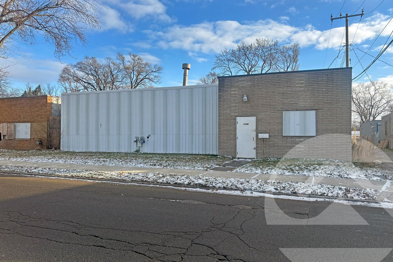
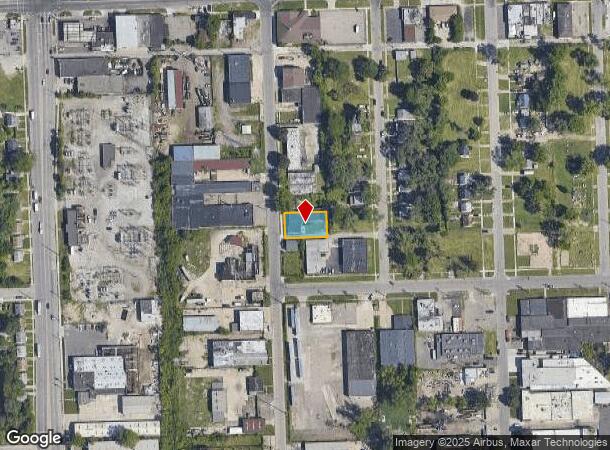
Property Record
13530 Auburn St, Detroit, MI 48223
NEARBY LISTINGS FOR SALE OR LEASE
Property Detail
13530 Auburn St
22-09242-930
Brightmoor Carlin Sub
Warehouse
E AUBURN 77&78 B E TAYLORS BRIGHTMOOR CARLIN SUB L51 P50 PLATS, WCR 22/510 70 X 121
X
Wayne
26163C0100E
Michigan
2024
0.19 AC
2024
Detroit West
543300
Detroit
4,656 SF
Detroit-Warren-Dearborn, MI
DEMOGRAPHICS near 13530 Auburn St
1 Mile
3 Mile
5 Mile
2024 Total Population
11,544
139,151
395,965
2029 Population
11,408
137,099
386,658
Pop Growth 2024-2029
(1.18%)
(1.47%)
(2.35%)
Average Age
37
37
38
2024 Total Households
4,399
53,452
148,852
HH Growth 2024-2029
(1.27%)
(1.62%)
(2.34%)
Median Household Inc
$41,063
$38,184
$42,942
Avg Household Size
2.60
2.50
2.60
2024 Avg HH Vehicles
2.00
1.00
1.00
Median Home Value
$88,747
$78,302
$107,280
Median Year Built
1948
1951
1952
Nearby Places
- Restaurants
- Banks
- Shops
- Fitness
- Groceries
PUBLIC TRANSPORTATION
COMMUTER RAIL
Dearborn (Wolverine - Amtrak)
DRIVE
WALK
Distance
Dearborn (Wolverine - Amtrak)
15 min
7.4 mi
AIRPORT
Detroit Metro Wayne County
DRIVE
WALK
Distance
Detroit Metro Wayne County
34 min
20.1 mi
Windsor International
DRIVE
WALK
Distance
Windsor International
40 min
22.7 mi
Freight Ports
Port of Toledo
DRIVE
WALK
Distance
Port of Toledo
82 min
62.1 mi
Nearby Properties
Address
Land Use
TOTAL SIZE
Lot Size
Zoning
Address
Land Use
TOTAL SIZE
Lot Size
Zoning
335,133 SF
22.08 AC
Address
Land Use
TOTAL SIZE
Lot Size
Zoning
515,664 SF
48.94 AC
M4
Address
Land Use
TOTAL SIZE
Lot Size
Zoning
85.45 AC
Address
Land Use
TOTAL SIZE
Lot Size
Zoning
300,936 SF
18.40 AC
M4
Address
Land Use
TOTAL SIZE
Lot Size
Zoning
261,917 SF
9.31 AC
PD
Address
Land Use
TOTAL SIZE
Lot Size
Zoning
202,736 SF
20 AC
PD
Address
Land Use
TOTAL SIZE
Lot Size
Zoning
486,416 SF
19.95 AC
M4
Address
Land Use
TOTAL SIZE
Lot Size
Zoning
835,383 SF
36.85 AC
Address
Land Use
TOTAL SIZE
Lot Size
Zoning
158,354 SF
43.70 AC
M4
Address
Land Use
TOTAL SIZE
Lot Size
Zoning
163,661 SF
8.92 AC
PD
Address
Land Use
TOTAL SIZE
Lot Size
Zoning
167,562 SF
9.25 AC
R5
Address
Land Use
TOTAL SIZE
Lot Size
Zoning
129,975 SF
6.89 AC
R5
Address
Land Use
TOTAL SIZE
Lot Size
Zoning
104,567 SF
2.14 AC
PD
Address
Land Use
TOTAL SIZE
Lot Size
Zoning
125,576 SF
5.56 AC
PD
Address
Land Use
TOTAL SIZE
Lot Size
Zoning
52.57 AC
Address
Land Use
TOTAL SIZE
Lot Size
Zoning
79,831 SF
7.60 AC
B3
Address
Land Use
TOTAL SIZE
Lot Size
Zoning
97,114 SF
2.10 AC
R1
Address
Land Use
TOTAL SIZE
Lot Size
Zoning
315,973 SF
12.18 AC
M4
Address
Land Use
TOTAL SIZE
Lot Size
Zoning
81,031 SF
8.15 AC
PD
Address
Land Use
TOTAL SIZE
Lot Size
Zoning
207,088 SF
14.25 AC
R-1
Address
Land Use
TOTAL SIZE
Lot Size
Zoning
362,981 SF
18.08 AC
M4
Address
Land Use
TOTAL SIZE
Lot Size
Zoning
106,597 SF
4.71 AC
PD
Address
Land Use
TOTAL SIZE
Lot Size
Zoning
277,067 SF
6.54 AC
M4
Address
Land Use
TOTAL SIZE
Lot Size
Zoning
69,712 SF
3.41 AC
PD
Address
Land Use
TOTAL SIZE
Lot Size
Zoning
43,095 SF
2.88 AC
R5
Address
Land Use
TOTAL SIZE
Lot Size
Zoning
95,862 SF
5.23 AC
PD
Address
Land Use
TOTAL SIZE
Lot Size
Zoning
89,147 SF
4.69 AC
PD
Address
Land Use
TOTAL SIZE
Lot Size
Zoning
142,362 SF
8.18 AC
Address
Land Use
TOTAL SIZE
Lot Size
Zoning
67,608 SF
2.34 AC
R5
Address
Land Use
TOTAL SIZE
Lot Size
Zoning
70,323 SF
3.86 AC
R5
The World's #1 Commercial Real Estate Marketplace
Connect with us
© 2025 CoStar Group
The information above has been obtained from sources believed reliable. While we do not doubt its accuracy we have not verified it and make no guarantee, warranty or representation about it. It is your responsibility to independently confirm its accuracy and completeness. Any projections, opinions, assumptions, or estimates used are for example only and do not represent the current or future performance of the property. The value of this transaction to you depends on tax and other factors which should be evaluated by your tax, financial, and legal advisors. You and your advisors should conduct a careful, independent investigation of the property to determine to your satisfaction the suitability of the property for your needs.