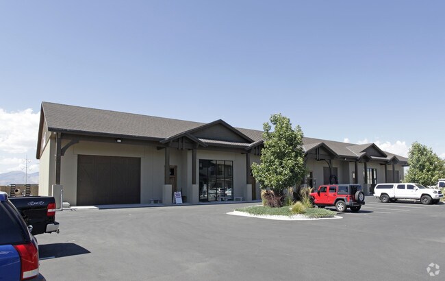
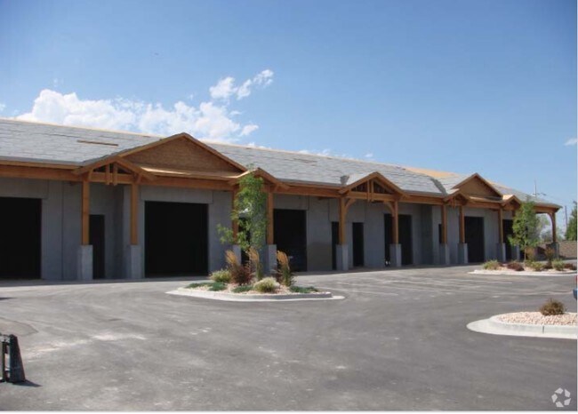
Property Record
13552 S 110 W, Draper, UT 84020


NEARBY LISTINGS FOR SALE OR LEASE
Property Detail
13552 S 110 W
Salt Lake City, UT
Radius Curve
33-01-227-006-0000
BEG 1055.73 S & 974.36 W & 138.4 FT N 0^0144] W & 0.78 FT S89^5816] W FR NE COR SEC 1, T 4S, R 1W, SLM; S 89^5816] W 313.94 FT TO ELY LINE OF JORDAN & SALT LAKE CANAL; S 249.65FT TO NLY LINE OF BANGERTER HWY; N 83^2947] E 316.87 FT; N00^0144] W 68.39
Officebuilding
Salt Lake
X
Utah
49035C0444G
1
2024
1.53 AC
2025
Draper
112825
Salt Lake City
17,868 SF
DEMOGRAPHICS near 13552 S 110 W
1 Mile
3 Mile
5 Mile
2024 Total Population
12,394
77,608
186,595
2029 Population
12,839
79,431
193,734
Pop Growth 2024-2029
+ 3.59%
+ 2.35%
+ 3.83%
Average Age
36
35
35
2024 Total Households
3,270
23,288
56,801
HH Growth 2024-2029
+ 4.59%
+ 2.40%
+ 3.79%
Median Household Inc
$93,714
$109,450
$111,571
Avg Household Size
2.90
3.20
3.20
2024 Avg HH Vehicles
2.00
2.00
2.00
Median Home Value
$715,471
$653,311
$624,313
Median Year Built
2008
2003
2002
Nearby Places
Map Layers
Map Styles
 Street
 Aerial
- Restaurants
- Banks
- Shops
- Fitness
- Groceries
PUBLIC TRANSPORTATION
COMMUTER RAIL
Draper Station (FrontRunner - Utah Transit Authority (UTA))
DRIVE
WALK
Distance
Draper Station (FrontRunner - Utah Transit Authority (UTA))
4 min
1.4 mi
South Jordan Station (FrontRunner - Utah Transit Authority (UTA))
DRIVE
WALK
Distance
South Jordan Station (FrontRunner - Utah Transit Authority (UTA))
9 min
5.0 mi
AIRPORT
Salt Lake City International
DRIVE
WALK
Distance
Salt Lake City International
30 min
23.8 mi
Provo Municipal
DRIVE
WALK
Distance
Provo Municipal
40 min
29.3 mi
Freight Ports
Port of Stockton
DRIVE
WALK
Distance
Port of Stockton
731 min
714.2 mi
Nearby Properties
Address
Land Use
TOTAL SIZE
Lot Size
Zoning
Address
Land Use
TOTAL SIZE
Lot Size
Zoning
161,466 SF
624.79 AC
M-1
Address
Land Use
TOTAL SIZE
Lot Size
Zoning
40,495 SF
33.28 AC
RM-1
Address
Land Use
TOTAL SIZE
Lot Size
Zoning
774,515 SF
87.50 AC
M-1
Address
Land Use
TOTAL SIZE
Lot Size
Zoning
1,055,572 SF
8.31 AC
CR
Address
Land Use
TOTAL SIZE
Lot Size
Zoning
210,421 SF
6.87 AC
CR
Address
Land Use
TOTAL SIZE
Lot Size
Zoning
392,144 SF
30.63 AC
1113
Address
Land Use
TOTAL SIZE
Lot Size
Zoning
423,208 SF
8.07 AC
CSD-H
Address
Land Use
TOTAL SIZE
Lot Size
Zoning
186,651 SF
35.87 AC
C-R
Address
Land Use
TOTAL SIZE
Lot Size
Zoning
277,938 SF
13.90 AC
CSD-DD
Address
Land Use
TOTAL SIZE
Lot Size
Zoning
359,628 SF
4.53 AC
TSD
Address
Land Use
TOTAL SIZE
Lot Size
Zoning
187,621 SF
3.64 AC
1103
Address
Land Use
TOTAL SIZE
Lot Size
Zoning
197,645 SF
19.51 AC
1122
Address
Land Use
TOTAL SIZE
Lot Size
Zoning
99,144 SF
6.23 AC
HC
Address
Land Use
TOTAL SIZE
Lot Size
Zoning
126,531 SF
11.50 AC
1244
Address
Land Use
TOTAL SIZE
Lot Size
Zoning
65,664 SF
16.47 AC
RM2
Address
Land Use
TOTAL SIZE
Lot Size
Zoning
311,202 SF
0.01 AC
4180
Address
Land Use
TOTAL SIZE
Lot Size
Zoning
391,078 SF
5.78 AC
IC
Address
Land Use
TOTAL SIZE
Lot Size
Zoning
416,562 SF
7.48 AC
CSDDPM
Address
Land Use
TOTAL SIZE
Lot Size
Zoning
101,790 SF
5.69 AC
PUD(16
Address
Land Use
TOTAL SIZE
Lot Size
Zoning
81,925 SF
10.13 AC
MU
Address
Land Use
TOTAL SIZE
Lot Size
Zoning
115,637 SF
36.38 AC
TSD
Address
Land Use
TOTAL SIZE
Lot Size
Zoning
374,097 SF
6.87 AC
CSDDPM
Address
Land Use
TOTAL SIZE
Lot Size
Zoning
130,809 SF
16.13 AC
RM 1
Address
Land Use
TOTAL SIZE
Lot Size
Zoning
265,332 SF
8.94 AC
C-C
Address
Land Use
TOTAL SIZE
Lot Size
Zoning
279,829 SF
18.28 AC
CSD-LP
Address
Land Use
TOTAL SIZE
Lot Size
Zoning
247,899 SF
9.20 AC
TSD
Address
Land Use
TOTAL SIZE
Lot Size
Zoning
296,237 SF
6.45 AC
TSD
Address
Land Use
TOTAL SIZE
Lot Size
Zoning
353,500 SF
29.38 AC
CR
Address
Land Use
TOTAL SIZE
Lot Size
Zoning
255,090 SF
17.91 AC
CSDDRC
Address
Land Use
TOTAL SIZE
Lot Size
Zoning
146,280 SF
0.01 AC
CBD
The World's #1 Commercial Real Estate Marketplace
Connect with us
© 2025 CoStar Group
The information above has been obtained from sources believed reliable. While we do not doubt its accuracy we have not verified it and make no guarantee, warranty or representation about it. It is your responsibility to independently confirm its accuracy and completeness. Any projections, opinions, assumptions, or estimates used are for example only and do not represent the current or future performance of the property. The value of this transaction to you depends on tax and other factors which should be evaluated by your tax, financial, and legal advisors. You and your advisors should conduct a careful, independent investigation of the property to determine to your satisfaction the suitability of the property for your needs.