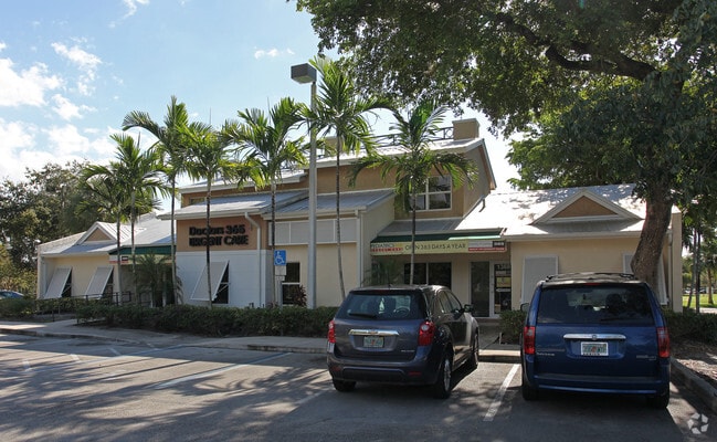
Property Record
1368 N University Dr, Plantation, FL 33322


NEARBY LISTINGS FOR SALE OR LEASE
Property Detail
1368 N University Dr
49-41-33-13-0048
Villas Of Plantation 100-6 B
Officebuilding
VILLAS OF PLANTATION 100-6 B PORTION PARCEL C DESC AS COMM SW COR PAR C,N 535.34,E 17.63 TO POB,NE 44.25,NW 3.55,NE 16.70,SE 3.55,NE 31.75,SE 54,SW 1.95,SE 2.41,SW 6,NW 2.41,SW 14.80,SE 9.36,SW 26.50,NW 3.86,SW 17.04, SE 1.84,SW 6,NW 7.34,SW 12.41,SE
X
Broward
12011C0345J
Florida
2024
0.13 AC
2025
Plantation
060501
South Florida
5,193 SF
Fort Lauderdale-Pompano Beach-Deerfield Beach, FL
DEMOGRAPHICS near 1368 N University Dr
1 Mile
3 Mile
5 Mile
2024 Total Population
18,810
185,776
439,276
2029 Population
18,578
185,602
438,840
Pop Growth 2024-2029
(1.23%)
(0.09%)
(0.10%)
Average Age
42
41
40
2024 Total Households
7,735
72,935
165,438
HH Growth 2024-2029
(1.62%)
(0.29%)
(0.36%)
Median Household Inc
$63,540
$56,748
$57,313
Avg Household Size
2.30
2.40
2.50
2024 Avg HH Vehicles
2.00
2.00
2.00
Median Home Value
$282,846
$281,696
$274,046
Median Year Built
1976
1979
1979
Nearby Places
Map Layers
Map Styles
 Street
 Aerial
- Restaurants
- Banks
- Shops
- Fitness
- Groceries
PUBLIC TRANSPORTATION
COMMUTER RAIL
Fort Lauderdale (Tri-County Commuter - South Florida Regional Transportation Authority (Tri-Rail))
DRIVE
WALK
Distance
Fort Lauderdale (Tri-County Commuter - South Florida Regional Transportation Authority (Tri-Rail))
15 min
7.3 mi
Fort Lauderdale (Mainline - Brightline)
DRIVE
WALK
Distance
Fort Lauderdale (Mainline - Brightline)
17 min
8.6 mi
AIRPORT
Fort Lauderdale/Hollywood International
DRIVE
WALK
Distance
Fort Lauderdale/Hollywood International
20 min
10.7 mi
Miami International
DRIVE
WALK
Distance
Miami International
49 min
34.7 mi
Freight Ports
Port Everglades
DRIVE
WALK
Distance
Port Everglades
20 min
12.7 mi
SALE & LEASE HISTORY
LISTING DATE
SALE/LEASE

Sep 24, 2016
For Lease
Sep 21, 2018
For Lease
Jun 29, 2020
For Lease
Aug 23, 2019
For Lease
Nearby Properties
Address
Land Use
TOTAL SIZE
Lot Size
Zoning
Address
Land Use
TOTAL SIZE
Lot Size
Zoning
663,255 SF
3.15 AC
RAC-CC
Address
Land Use
TOTAL SIZE
Lot Size
Zoning
632,250 SF
34.15 AC
PRD-11.6Q
Address
Land Use
TOTAL SIZE
Lot Size
Zoning
458,854 SF
30.97 AC
PRD-15Q **
Address
Land Use
TOTAL SIZE
Lot Size
Zoning
627,368 SF
4.33 AC
PRD-21Q
Address
Land Use
TOTAL SIZE
Lot Size
Zoning
507,890 SF
39.49 AC
M-PM
Address
Land Use
TOTAL SIZE
Lot Size
Zoning
613,363 SF
6.24 AC
B-7Q
Address
Land Use
TOTAL SIZE
Lot Size
Zoning
517,961 SF
3.92 AC
M-PM
Address
Land Use
TOTAL SIZE
Lot Size
Zoning
497,004 SF
4.46 AC
M-PM
Address
Land Use
TOTAL SIZE
Lot Size
Zoning
524,015 SF
6.43 AC
B-7Q
Address
Land Use
TOTAL SIZE
Lot Size
Zoning
333,099 SF
9.03 AC
PRD-10Q
Address
Land Use
TOTAL SIZE
Lot Size
Zoning
471,109 SF
5.57 AC
M-PM
Address
Land Use
TOTAL SIZE
Lot Size
Zoning
527,086 SF
2.34 AC
M-PM
Address
Land Use
TOTAL SIZE
Lot Size
Zoning
346,662 SF
26.47 AC
RM-18
Address
Land Use
TOTAL SIZE
Lot Size
Zoning
326,159 SF
15.30 AC
PDD
Address
Land Use
TOTAL SIZE
Lot Size
Zoning
320,919 SF
27.70 AC
M-PM
Address
Land Use
TOTAL SIZE
Lot Size
Zoning
439,908 SF
13.54 AC
OP-P
Address
Land Use
TOTAL SIZE
Lot Size
Zoning
256,568 SF
22.61 AC
PRD-12.15Q
Address
Land Use
TOTAL SIZE
Lot Size
Zoning
312,067 SF
20.94 AC
PRD-15Q
Address
Land Use
TOTAL SIZE
Lot Size
Zoning
321,240 SF
2.16 AC
M-PM
Address
Land Use
TOTAL SIZE
Lot Size
Zoning
296,166 SF
18.40 AC
RM-18
Address
Land Use
TOTAL SIZE
Lot Size
Zoning
277,664 SF
21.35 AC
PRD-12.15Q
Address
Land Use
TOTAL SIZE
Lot Size
Zoning
445,798 SF
11.80 AC
OP-P
Address
Land Use
TOTAL SIZE
Lot Size
Zoning
300,359 SF
11.76 AC
PRD-15.7Q
Address
Land Use
TOTAL SIZE
Lot Size
Zoning
234,496 SF
3.07 AC
M-PM
Address
Land Use
TOTAL SIZE
Lot Size
Zoning
231,498 SF
19.56 AC
PRD-12.15Q
Address
Land Use
TOTAL SIZE
Lot Size
Zoning
157,841 SF
3.03 AC
I-L2P
Address
Land Use
TOTAL SIZE
Lot Size
Zoning
405,695 SF
10.08 AC
M-PM
Address
Land Use
TOTAL SIZE
Lot Size
Zoning
248,539 SF
0.13 AC
M-PM
Address
Land Use
TOTAL SIZE
Lot Size
Zoning
242,841 SF
17.21 AC
M-PM
Address
Land Use
TOTAL SIZE
Lot Size
Zoning
264,127 SF
24.02 AC
B-3
The World's #1 Commercial Real Estate Marketplace
Connect with us
© 2026 CoStar Group
The information above has been obtained from sources believed reliable. While we do not doubt its accuracy we have not verified it and make no guarantee, warranty or representation about it. It is your responsibility to independently confirm its accuracy and completeness. Any projections, opinions, assumptions, or estimates used are for example only and do not represent the current or future performance of the property. The value of this transaction to you depends on tax and other factors which should be evaluated by your tax, financial, and legal advisors. You and your advisors should conduct a careful, independent investigation of the property to determine to your satisfaction the suitability of the property for your needs.