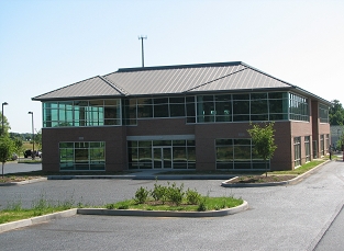
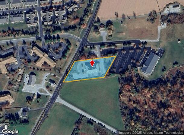
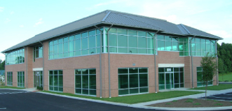
Property Record
137 S Jennersville Rd, West Grove, PA 19390

NEARBY LISTINGS FOR SALE OR LEASE
Property Detail
137 S Jennersville Rd
58-004-0051.0000
1.9 AC & COMM BLDG
Officebuilding
Chester
X
Pennsylvania
42029C0285G
1.94 AC
2024
Outer Chester County
2024
Philadelphia
307000
Philadelphia-Camden-Wilmington, PA-NJ-DE-MD
18,888 SF
DEMOGRAPHICS near 137 S Jennersville Rd
1 Mile
3 Mile
5 Mile
2024 Total Population
2,413
18,026
37,907
2029 Population
2,560
18,761
39,320
Pop Growth 2024-2029
+ 6.09%
+ 4.08%
+ 3.73%
Average Age
49
40
40
2024 Total Households
1,059
5,756
12,181
HH Growth 2024-2029
+ 6.33%
+ 4.81%
+ 4.15%
Median Household Inc
$78,380
$97,739
$112,747
Avg Household Size
2.20
2.70
2.90
2024 Avg HH Vehicles
1.00
2.00
2.00
Median Home Value
$315,761
$354,533
$376,741
Median Year Built
2001
1993
1993
Nearby Places
- Restaurants
- Banks
- Shops
- Fitness
- Groceries
SALE & LEASE HISTORY
LISTING DATE
SALE/LEASE

Sep 25, 2016
For Lease
Sep 25, 2016
For Lease
Sep 24, 2016
For Sale
Oct 17, 2018
For Lease
Nearby Properties
Address
Land Use
TOTAL SIZE
Lot Size
Zoning
Address
Land Use
TOTAL SIZE
Lot Size
Zoning
597,923 SF
84.42 AC
C2
Address
Land Use
TOTAL SIZE
Lot Size
Zoning
343,977 SF
153.80 AC
I1
Address
Land Use
TOTAL SIZE
Lot Size
Zoning
309,221 SF
66 AC
RR
Address
Land Use
TOTAL SIZE
Lot Size
Zoning
192,327 SF
57.60 AC
R2
Address
Land Use
TOTAL SIZE
Lot Size
Zoning
153,934 SF
77.48 AC
R2
Address
Land Use
TOTAL SIZE
Lot Size
Zoning
116,710 SF
48.60 AC
R2
Address
Land Use
TOTAL SIZE
Lot Size
Zoning
145,023 SF
12.40 AC
R2
Address
Land Use
TOTAL SIZE
Lot Size
Zoning
142,531 SF
26.09 AC
C2
Address
Land Use
TOTAL SIZE
Lot Size
Zoning
72,440 SF
3 AC
C2
Address
Land Use
TOTAL SIZE
Lot Size
Zoning
187,300 SF
41 AC
R2
Address
Land Use
TOTAL SIZE
Lot Size
Zoning
55,640 SF
17 AC
R2
Address
Land Use
TOTAL SIZE
Lot Size
Zoning
75,831 SF
0.79 AC
R3
Address
Land Use
TOTAL SIZE
Lot Size
Zoning
194,564 SF
16 AC
I1
Address
Land Use
TOTAL SIZE
Lot Size
Zoning
81,713 SF
5.52 AC
R3
Address
Land Use
TOTAL SIZE
Lot Size
Zoning
71,064 SF
45.22 AC
C2
Address
Land Use
TOTAL SIZE
Lot Size
Zoning
82,545 SF
26.30 AC
R2
Address
Land Use
TOTAL SIZE
Lot Size
Zoning
50,234 SF
16.40 AC
RR
Address
Land Use
TOTAL SIZE
Lot Size
Zoning
70,360 SF
3.37 AC
R2
Address
Land Use
TOTAL SIZE
Lot Size
Zoning
40,872 SF
0.54 AC
R3
Address
Land Use
TOTAL SIZE
Lot Size
Zoning
55,497 SF
3.47 AC
R2
Address
Land Use
TOTAL SIZE
Lot Size
Zoning
55,497 SF
3.83 AC
R2
Address
Land Use
TOTAL SIZE
Lot Size
Zoning
56,660 SF
R2
Address
Land Use
TOTAL SIZE
Lot Size
Zoning
120,230 SF
16 AC
R2
Address
Land Use
TOTAL SIZE
Lot Size
Zoning
44,995 SF
0.70 AC
R3
Address
Land Use
TOTAL SIZE
Lot Size
Zoning
18,260 SF
80.32 AC
R1
Address
Land Use
TOTAL SIZE
Lot Size
Zoning
35,015 SF
7.30 AC
I1
Address
Land Use
TOTAL SIZE
Lot Size
Zoning
37,827 SF
5.26 AC
R2
Address
Land Use
TOTAL SIZE
Lot Size
Zoning
103,151 SF
7.25 AC
R3
Address
Land Use
TOTAL SIZE
Lot Size
Zoning
66.09 AC
I1
Address
Land Use
TOTAL SIZE
Lot Size
Zoning
111,794 SF
40.45 AC
I
The World's #1 Commercial Real Estate Marketplace
Connect with us
© 2025 CoStar Group
The information above has been obtained from sources believed reliable. While we do not doubt its accuracy we have not verified it and make no guarantee, warranty or representation about it. It is your responsibility to independently confirm its accuracy and completeness. Any projections, opinions, assumptions, or estimates used are for example only and do not represent the current or future performance of the property. The value of this transaction to you depends on tax and other factors which should be evaluated by your tax, financial, and legal advisors. You and your advisors should conduct a careful, independent investigation of the property to determine to your satisfaction the suitability of the property for your needs.