Property Record
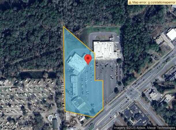
1371 S Walnut St, Starke, FL 32091
NEARBY LISTINGS FOR SALE OR LEASE
Property Detail
1371 S Walnut St
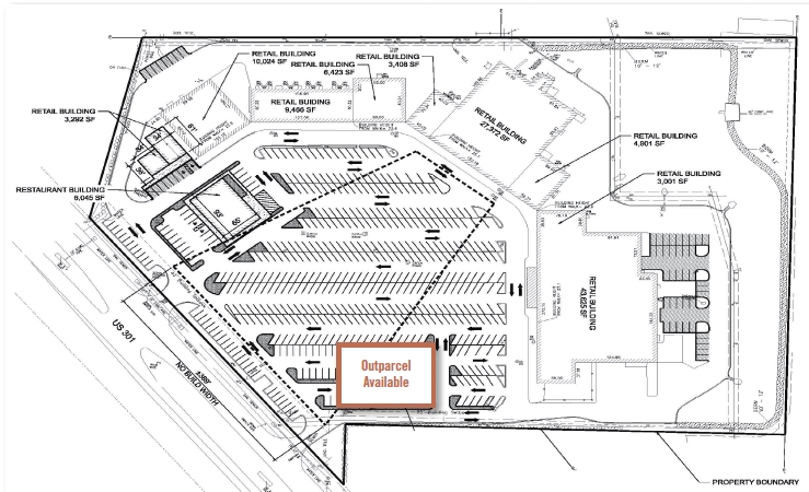
Communitycenter
32 6S 22 BEG AT NW COR OF NW1/4 OF SE1/4 OF NE1/4, S02*5119E 1002.86, S78*5630E 335.14, N48*1030E 151.61, THENCE N02*5119W 340.32, THENCE N87*0841W 90.98, THENCE N02*5119W 325, THENCE N50*2057W 478.19 TO POB
AE
Bradford
12007C0211F
Florida
2024
7.92 AC
2024
Florida Central North Area
000201
Other Market Areas
74,461 SF
04229-0-00200
DEMOGRAPHICS near 1371 S Walnut St
1 Mile
3 Mile
5 Mile
2024 Total Population
1,899
9,169
13,282
2029 Population
1,973
9,582
13,853
Pop Growth 2024-2029
+ 3.90%
+ 4.50%
+ 4.30%
Average Age
41
41
41
2024 Total Households
736
3,488
5,029
HH Growth 2024-2029
+ 3.26%
+ 3.73%
+ 3.60%
Median Household Inc
$44,434
$45,317
$45,616
Avg Household Size
2.50
2.50
2.50
2024 Avg HH Vehicles
2.00
2.00
2.00
Median Home Value
$104,362
$122,108
$125,837
Median Year Built
1980
1981
1983
Nearby Places
- Restaurants
- Banks
- Shops
- Fitness
- Groceries
PUBLIC TRANSPORTATION
AIRPORT
Gainesville Regional
DRIVE
WALK
Distance
Gainesville Regional
35 min
22.9 mi
Freight Ports
Jacksonville Port
DRIVE
WALK
Distance
Jacksonville Port
69 min
50.0 mi
SALE & LEASE HISTORY
LISTING DATE
SALE/LEASE

Sep 24, 2016
For Sale
Nearby Properties
Address
Land Use
TOTAL SIZE
Lot Size
Zoning
Address
Land Use
TOTAL SIZE
Lot Size
Zoning
168,336 SF
23.97 AC
Address
Land Use
TOTAL SIZE
Lot Size
Zoning
585.31 AC
Address
Land Use
TOTAL SIZE
Lot Size
Zoning
96,617 SF
11 AC
Address
Land Use
TOTAL SIZE
Lot Size
Zoning
63,568 SF
8.54 AC
Address
Land Use
TOTAL SIZE
Lot Size
Zoning
117,119 SF
30.15 AC
Address
Land Use
TOTAL SIZE
Lot Size
Zoning
64,054 SF
4.07 AC
Address
Land Use
TOTAL SIZE
Lot Size
Zoning
119,949 SF
5.50 AC
Address
Land Use
TOTAL SIZE
Lot Size
Zoning
69,258 SF
10 AC
Address
Land Use
TOTAL SIZE
Lot Size
Zoning
111,635 SF
44.63 AC
Address
Land Use
TOTAL SIZE
Lot Size
Zoning
35,032 SF
8.75 AC
Address
Land Use
TOTAL SIZE
Lot Size
Zoning
30,963 SF
7.47 AC
Address
Land Use
TOTAL SIZE
Lot Size
Zoning
42,534 SF
1.86 AC
Address
Land Use
TOTAL SIZE
Lot Size
Zoning
47,283 SF
5.70 AC
Address
Land Use
TOTAL SIZE
Lot Size
Zoning
24,370 SF
1.27 AC
Address
Land Use
TOTAL SIZE
Lot Size
Zoning
648 AC
Address
Land Use
TOTAL SIZE
Lot Size
Zoning
Address
Land Use
TOTAL SIZE
Lot Size
Zoning
644 AC
Address
Land Use
TOTAL SIZE
Lot Size
Zoning
644 AC
Address
Land Use
TOTAL SIZE
Lot Size
Zoning
Address
Land Use
TOTAL SIZE
Lot Size
Zoning
Address
Land Use
TOTAL SIZE
Lot Size
Zoning
642 AC
Address
Land Use
TOTAL SIZE
Lot Size
Zoning
641 AC
Address
Land Use
TOTAL SIZE
Lot Size
Zoning
Address
Land Use
TOTAL SIZE
Lot Size
Zoning
Address
Land Use
TOTAL SIZE
Lot Size
Zoning
38,431 SF
13.76 AC
Address
Land Use
TOTAL SIZE
Lot Size
Zoning
51,918 SF
7.97 AC
Address
Land Use
TOTAL SIZE
Lot Size
Zoning
Address
Land Use
TOTAL SIZE
Lot Size
Zoning
Address
Land Use
TOTAL SIZE
Lot Size
Zoning
11,061 SF
638 AC
The World's #1 Commercial Real Estate Marketplace
Connect with us
© 2025 CoStar Group
The information above has been obtained from sources believed reliable. While we do not doubt its accuracy we have not verified it and make no guarantee, warranty or representation about it. It is your responsibility to independently confirm its accuracy and completeness. Any projections, opinions, assumptions, or estimates used are for example only and do not represent the current or future performance of the property. The value of this transaction to you depends on tax and other factors which should be evaluated by your tax, financial, and legal advisors. You and your advisors should conduct a careful, independent investigation of the property to determine to your satisfaction the suitability of the property for your needs.