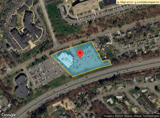
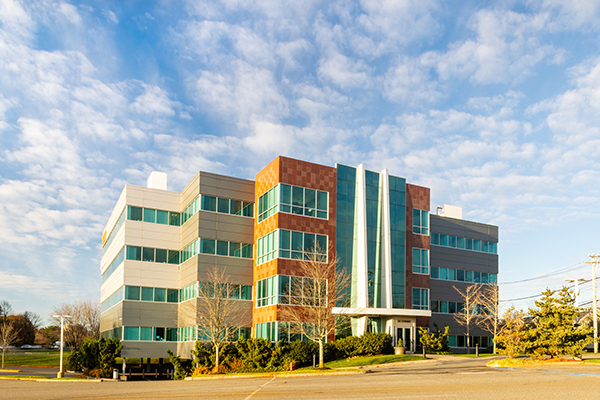
Property Record
138 Conant St, Beverly, MA 01915

Current Lease Availabilities
NEARBY LISTINGS FOR SALE OR LEASE
Property Detail
138 Conant St
Multipleuses
Essex
X
Massachusetts
25009C0409F
3.12 AC
2019
Danvers/Beverly
2024
Boston
217102
Boston-Cambridge-Newton, MA-NH
66,428 SF
BEVE M:0078 B:013C L:
DEMOGRAPHICS near 138 Conant St
1 Mile
3 Mile
5 Mile
2024 Total Population
7,777
70,422
161,151
2029 Population
7,765
70,127
160,031
Pop Growth 2024-2029
(0.15%)
(0.42%)
(0.70%)
Average Age
43
42
42
2024 Total Households
3,170
28,552
65,784
HH Growth 2024-2029
(0.28%)
(0.55%)
(0.83%)
Median Household Inc
$101,136
$95,203
$87,366
Avg Household Size
2.40
2.40
2.30
2024 Avg HH Vehicles
2.00
2.00
2.00
Median Home Value
$561,833
$573,951
$542,226
Median Year Built
1959
1957
1959
Nearby Places
- Restaurants
- Banks
- Shops
- Fitness
- Groceries
PUBLIC TRANSPORTATION
COMMUTER RAIL
North Beverly (Newburyport/Rockport Line - Massachusetts Bay Transportation Authority Commuter Rail (Purple Line))
Drive
Walk
Distance
North Beverly (Newburyport/Rockport Line - Massachusetts Bay Transportation Authority Commuter Rail (Purple Line))
3 min
1.6 mi
Montserrat (Newburyport/Rockport Line - Massachusetts Bay Transportation Authority Commuter Rail (Purple Line))
Drive
Walk
Distance
Montserrat (Newburyport/Rockport Line - Massachusetts Bay Transportation Authority Commuter Rail (Purple Line))
5 min
2.9 mi
AIRPORT
General Edward Lawrence Logan International
Drive
Walk
Distance
General Edward Lawrence Logan International
34 min
20.8 mi
Freight Ports
Port of Boston
Drive
Walk
Distance
Port of Boston
37 min
23.8 mi
Nearby Properties
Address
Land Use
TOTAL SIZE
Lot Size
Zoning
Address
Land Use
TOTAL SIZE
Lot Size
Zoning
48.89 AC
IG
Address
Land Use
TOTAL SIZE
Lot Size
Zoning
252965
56.44 AC
R3
Address
Land Use
TOTAL SIZE
Lot Size
Zoning
496607
71.29 AC
R45
Address
Land Use
TOTAL SIZE
Lot Size
Zoning
49 AC
I2
Address
Land Use
TOTAL SIZE
Lot Size
Zoning
267051
41.08 AC
R10
Address
Land Use
TOTAL SIZE
Lot Size
Zoning
228295
12.50 AC
RMD
Address
Land Use
TOTAL SIZE
Lot Size
Zoning
172.50 AC
R3
Address
Land Use
TOTAL SIZE
Lot Size
Zoning
231509
17.71 AC
R10
Address
Land Use
TOTAL SIZE
Lot Size
Zoning
182122
23.33 AC
R10
Address
Land Use
TOTAL SIZE
Lot Size
Zoning
11.08 AC
R4
Address
Land Use
TOTAL SIZE
Lot Size
Zoning
207237
16.73 AC
RMD
Address
Land Use
TOTAL SIZE
Lot Size
Zoning
408207
37.12 AC
C3
Address
Land Use
TOTAL SIZE
Lot Size
Zoning
170652
23.73 AC
HD
Address
Land Use
TOTAL SIZE
Lot Size
Zoning
170652
23.73 AC
HD
Address
Land Use
TOTAL SIZE
Lot Size
Zoning
195527
16.60 AC
CG
Address
Land Use
TOTAL SIZE
Lot Size
Zoning
15.16 AC
I2
Address
Land Use
TOTAL SIZE
Lot Size
Zoning
358662
36.98 AC
IR
Address
Land Use
TOTAL SIZE
Lot Size
Zoning
162182
9.53 AC
IR
Address
Land Use
TOTAL SIZE
Lot Size
Zoning
111.24 AC
R3
Address
Land Use
TOTAL SIZE
Lot Size
Zoning
37553
238.29 AC
IR
Address
Land Use
TOTAL SIZE
Lot Size
Zoning
177782
12.21 AC
I2
Address
Land Use
TOTAL SIZE
Lot Size
Zoning
278284
23.20 AC
RSD
Address
Land Use
TOTAL SIZE
Lot Size
Zoning
111256
0.66 AC
CC
Address
Land Use
TOTAL SIZE
Lot Size
Zoning
20.78 AC
C3
Address
Land Use
TOTAL SIZE
Lot Size
Zoning
24.37 AC
C3
Address
Land Use
TOTAL SIZE
Lot Size
Zoning
112023
0.74 AC
CC
Address
Land Use
TOTAL SIZE
Lot Size
Zoning
158572
10 AC
I2
Address
Land Use
TOTAL SIZE
Lot Size
Zoning
123171
9.09 AC
R10
Address
Land Use
TOTAL SIZE
Lot Size
Zoning
139582
31.13 AC
R1
Address
Land Use
TOTAL SIZE
Lot Size
Zoning
91168
2.09 AC
CC
Start a new search to find other properties for sale or lease
Connect with us
© 2024 CoStar Group
The information above has been obtained from sources believed reliable. While we do not doubt its accuracy we have not verified it and make no guarantee, warranty or representation about it. It is your responsibility to independently confirm its accuracy and completeness. Any projections, opinions, assumptions, or estimates used are for example only and do not represent the current or future performance of the property. The value of this transaction to you depends on tax and other factors which should be evaluated by your tax, financial, and legal advisors. You and your advisors should conduct a careful, independent investigation of the property to determine to your satisfaction the suitability of the property for your needs.