Property Record
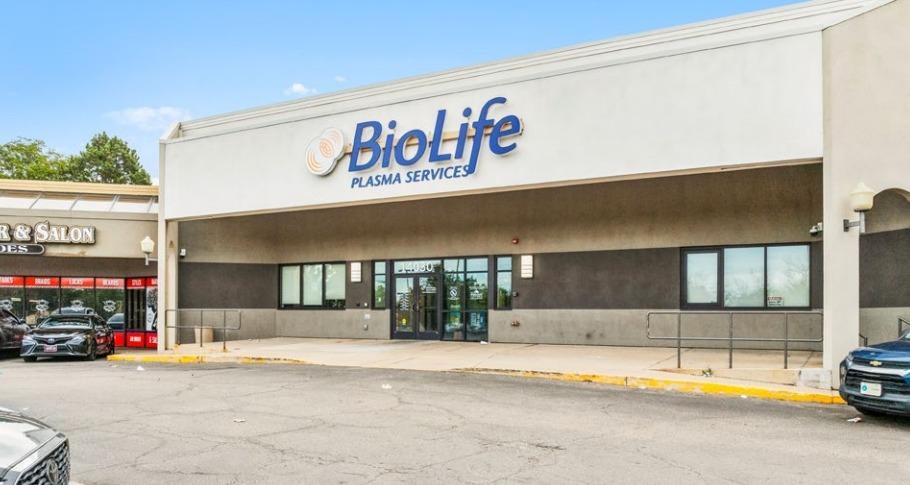
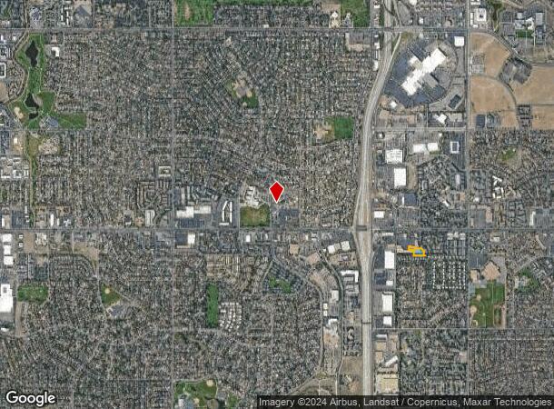
13900 E Mississippi Ave, Aurora, CO 80012

This Property Is For Sale
NEARBY LISTINGS FOR SALE OR LEASE
Property Detail
13900 E Mississippi Ave
Denver-Aurora-Lakewood, CO
Town & Country Village Sub 2Nd Flg
1975-19-2-34-002
SUBDIVISIONCD 062225 SUBDIVISIONNAME TOWN & COUNTRY VILLAGE SUB 2ND FLG BLOCK 001 LOT 002 LOT 2 BLK 1 TOWN AND COUNTRY VILLAGE SUB 2ND FLG
Storebuilding
Arapahoe
X
Colorado
08005C0179L
002
2023
1.39 AC
2024
Aurora
080800
Denver
15,961 SF
DEMOGRAPHICS near 13900 E Mississippi Ave
1 Mile
3 Mile
5 Mile
2024 Total Population
24,805
183,060
420,118
2029 Population
25,026
184,003
424,678
Pop Growth 2024-2029
+ 0.89%
+ 0.52%
+ 1.09%
Average Age
36
38
38
2024 Total Households
9,694
71,255
165,028
HH Growth 2024-2029
+ 1.00%
+ 0.51%
+ 1.09%
Median Household Inc
$61,488
$63,387
$66,048
Avg Household Size
2.50
2.50
2.40
2024 Avg HH Vehicles
2.00
2.00
2.00
Median Home Value
$314,762
$360,944
$386,030
Median Year Built
1980
1980
1981
Nearby Places
- Restaurants
- Banks
- Shops
- Fitness
- Groceries
PUBLIC TRANSPORTATION
TRANSIT/SUBWAY
Florida Station (18th & California Station to Florida Station - Regional Transportation District, Lincoln Station to Peoria Station - Regional Transportation District)
DRIVE
WALK
Distance
Florida Station (18th & California Station to Florida Station - Regional Transportation District, Lincoln Station to Peoria Station - Regional Transportation District)
3 min
19 min
1.0 mi
COMMUTER RAIL
Peoria Station Track 1 (Union Station to Denver Airport Station - Regional Transportation District)
DRIVE
WALK
Distance
Peoria Station Track 1 (Union Station to Denver Airport Station - Regional Transportation District)
12 min
7.5 mi
Peoria Station Track 2 (Union Station to Denver Airport Station - Regional Transportation District)
DRIVE
WALK
Distance
Peoria Station Track 2 (Union Station to Denver Airport Station - Regional Transportation District)
12 min
7.6 mi
AIRPORT
Denver International
DRIVE
WALK
Distance
Denver International
25 min
19.3 mi
Freight Ports
Tulsa Port Of Catoosa
DRIVE
WALK
Distance
Tulsa Port Of Catoosa
721 min
702.0 mi
Nearby Properties
Address
Land Use
TOTAL SIZE
Lot Size
Zoning
Address
Land Use
TOTAL SIZE
Lot Size
Zoning
496,493 SF
33.45 AC
Address
Land Use
TOTAL SIZE
Lot Size
Zoning
476,186 SF
42.62 AC
Address
Land Use
TOTAL SIZE
Lot Size
Zoning
613,600 SF
29.40 AC
R-3
Address
Land Use
TOTAL SIZE
Lot Size
Zoning
315,058 SF
36.85 AC
RPCZD
Address
Land Use
TOTAL SIZE
Lot Size
Zoning
672,521 SF
0.61 AC
RB3
Address
Land Use
TOTAL SIZE
Lot Size
Zoning
277,985 SF
19.07 AC
Address
Land Use
TOTAL SIZE
Lot Size
Zoning
178,235 SF
1.38 AC
RFBAD
Address
Land Use
TOTAL SIZE
Lot Size
Zoning
201,600 SF
44.67 AC
R1
Address
Land Use
TOTAL SIZE
Lot Size
Zoning
478,994 SF
26.07 AC
Address
Land Use
TOTAL SIZE
Lot Size
Zoning
540,380 SF
26.03 AC
RR3
Address
Land Use
TOTAL SIZE
Lot Size
Zoning
383,436 SF
9.77 AC
Address
Land Use
TOTAL SIZE
Lot Size
Zoning
220,395 SF
7.93 AC
Address
Land Use
TOTAL SIZE
Lot Size
Zoning
366,800 SF
20.21 AC
Address
Land Use
TOTAL SIZE
Lot Size
Zoning
186,088 SF
10.15 AC
RZIND
Address
Land Use
TOTAL SIZE
Lot Size
Zoning
176,751 SF
28.75 AC
Address
Land Use
TOTAL SIZE
Lot Size
Zoning
130,531 SF
3.41 AC
Address
Land Use
TOTAL SIZE
Lot Size
Zoning
624,019 SF
4.09 AC
Address
Land Use
TOTAL SIZE
Lot Size
Zoning
462,048 SF
5.34 AC
RB3
Address
Land Use
TOTAL SIZE
Lot Size
Zoning
521,364 SF
14.88 AC
PUD
Address
Land Use
TOTAL SIZE
Lot Size
Zoning
1,344,255 SF
15.88 AC
AMU
Address
Land Use
TOTAL SIZE
Lot Size
Zoning
327,934 SF
17.52 AC
PUD
Address
Land Use
TOTAL SIZE
Lot Size
Zoning
540,166 SF
2.80 AC
Address
Land Use
TOTAL SIZE
Lot Size
Zoning
649,712 SF
47.31 AC
Address
Land Use
TOTAL SIZE
Lot Size
Zoning
232,697 SF
12.09 AC
Address
Land Use
TOTAL SIZE
Lot Size
Zoning
328,315 SF
8.15 AC
Address
Land Use
TOTAL SIZE
Lot Size
Zoning
458,149 SF
5.58 AC
B-2
Address
Land Use
TOTAL SIZE
Lot Size
Zoning
503,283 SF
32.93 AC
R-2-A
Address
Land Use
TOTAL SIZE
Lot Size
Zoning
353,956 SF
8.28 AC
R-3
Address
Land Use
TOTAL SIZE
Lot Size
Zoning
127,530 SF
20.76 AC
The World's #1 Commercial Real Estate Marketplace
Connect with us
© 2025 CoStar Group
The information above has been obtained from sources believed reliable. While we do not doubt its accuracy we have not verified it and make no guarantee, warranty or representation about it. It is your responsibility to independently confirm its accuracy and completeness. Any projections, opinions, assumptions, or estimates used are for example only and do not represent the current or future performance of the property. The value of this transaction to you depends on tax and other factors which should be evaluated by your tax, financial, and legal advisors. You and your advisors should conduct a careful, independent investigation of the property to determine to your satisfaction the suitability of the property for your needs.