Property Record
140 W Duval Mine Rd, Green Valley, AZ 85614
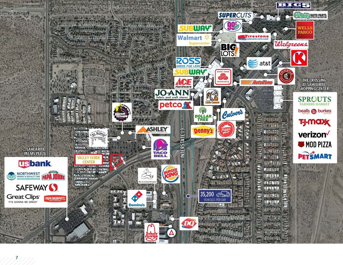
NEARBY LISTINGS FOR SALE OR LEASE
Property Detail
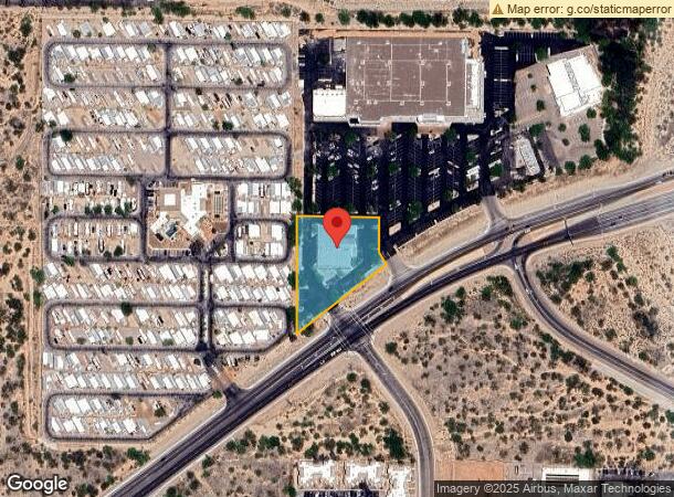
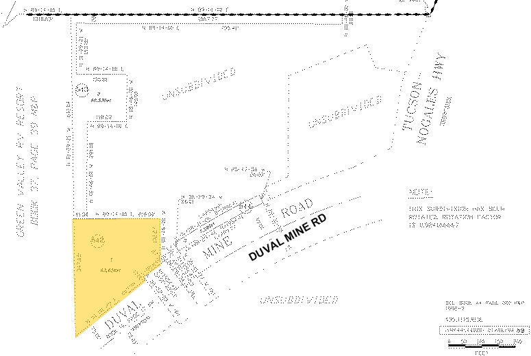
140 W Duval Mine Rd
Tucson, AZ
Bullhead Properties
303-33-5420
BULLHEAD PROPERTIES LOT 1
Stripcommercialcenter
Pima
X
Arizona
04019C3465L
1
2023
1.46 AC
2024
South/SW Outlying
004327
Tucson
11,956 SF
DEMOGRAPHICS near 140 W Duval Mine Rd
1 Mile
3 Mile
5 Mile
2024 Total Population
5,918
25,896
43,209
2029 Population
6,073
27,139
45,296
Pop Growth 2024-2029
+ 2.62%
+ 4.80%
+ 4.83%
Average Age
48
55
55
2024 Total Households
2,721
12,603
20,538
HH Growth 2024-2029
+ 2.72%
+ 4.99%
+ 5.03%
Median Household Inc
$47,621
$58,483
$64,916
Avg Household Size
2.20
2.00
2.10
2024 Avg HH Vehicles
2.00
2.00
2.00
Median Home Value
$175,338
$244,477
$270,645
Median Year Built
1996
1995
1999
Nearby Places
- Restaurants
- Banks
- Shops
- Fitness
- Groceries
PUBLIC TRANSPORTATION
AIRPORT
Tucson International
DRIVE
WALK
Distance
Tucson International
27 min
19.9 mi
Freight Ports
Port of San Diego
DRIVE
WALK
Distance
Port of San Diego
458 min
430.3 mi
SALE & LEASE HISTORY
LISTING DATE
SALE/LEASE

Sep 24, 2016
For Sale
Sep 23, 2016
For Sale
Oct 28, 2016
For Sale
Mar 01, 2017
For Sale
Mar 01, 2017
For Sale
Nearby Properties
Address
Land Use
TOTAL SIZE
Lot Size
Zoning
Address
Land Use
TOTAL SIZE
Lot Size
Zoning
81,624 SF
8.11 AC
CR4
Address
Land Use
TOTAL SIZE
Lot Size
Zoning
183,470 SF
18.20 AC
CB2
Address
Land Use
TOTAL SIZE
Lot Size
Zoning
20,400 SF
2.25 AC
CB2
Address
Land Use
TOTAL SIZE
Lot Size
Zoning
89,760 SF
9.42 AC
Address
Land Use
TOTAL SIZE
Lot Size
Zoning
19,250 SF
5.37 AC
GR1
Address
Land Use
TOTAL SIZE
Lot Size
Zoning
81,011 SF
5.56 AC
TR
Address
Land Use
TOTAL SIZE
Lot Size
Zoning
19,000 SF
648.25 AC
Address
Land Use
TOTAL SIZE
Lot Size
Zoning
92,411 SF
8.88 AC
CB1
Address
Land Use
TOTAL SIZE
Lot Size
Zoning
54,921 SF
6.75 AC
CB2
Address
Land Use
TOTAL SIZE
Lot Size
Zoning
56,544 SF
3.20 AC
CB2
Address
Land Use
TOTAL SIZE
Lot Size
Zoning
15,365 SF
1.79 AC
Address
Land Use
TOTAL SIZE
Lot Size
Zoning
62,175 SF
7.60 AC
Address
Land Use
TOTAL SIZE
Lot Size
Zoning
37,501 SF
10.10 AC
RH
Address
Land Use
TOTAL SIZE
Lot Size
Zoning
28,437 SF
4.13 AC
RH
Address
Land Use
TOTAL SIZE
Lot Size
Zoning
23,844 SF
5.22 AC
Address
Land Use
TOTAL SIZE
Lot Size
Zoning
94,916 SF
5.33 AC
CR4
Address
Land Use
TOTAL SIZE
Lot Size
Zoning
73,616 SF
13.80 AC
CB2
Address
Land Use
TOTAL SIZE
Lot Size
Zoning
29,189 SF
8.86 AC
RH
Address
Land Use
TOTAL SIZE
Lot Size
Zoning
71,082 SF
8.21 AC
Address
Land Use
TOTAL SIZE
Lot Size
Zoning
79,128 SF
3.49 AC
CB2
Address
Land Use
TOTAL SIZE
Lot Size
Zoning
24,435 SF
2.53 AC
TR
Address
Land Use
TOTAL SIZE
Lot Size
Zoning
21,734 SF
4.08 AC
Address
Land Use
TOTAL SIZE
Lot Size
Zoning
390 SF
1.67 AC
CB2
Address
Land Use
TOTAL SIZE
Lot Size
Zoning
23,905 SF
2.96 AC
RH
Address
Land Use
TOTAL SIZE
Lot Size
Zoning
98,808 SF
8.44 AC
GR1
Address
Land Use
TOTAL SIZE
Lot Size
Zoning
7,000 SF
1.39 AC
CR4
Address
Land Use
TOTAL SIZE
Lot Size
Zoning
64,251 SF
4.21 AC
Address
Land Use
TOTAL SIZE
Lot Size
Zoning
3,565 SF
2.12 AC
CB1
Address
Land Use
TOTAL SIZE
Lot Size
Zoning
28,573 SF
1.59 AC
CB2
Address
Land Use
TOTAL SIZE
Lot Size
Zoning
19,114 SF
0.67 AC
CB2
The World's #1 Commercial Real Estate Marketplace
Connect with us
© 2025 CoStar Group
The information above has been obtained from sources believed reliable. While we do not doubt its accuracy we have not verified it and make no guarantee, warranty or representation about it. It is your responsibility to independently confirm its accuracy and completeness. Any projections, opinions, assumptions, or estimates used are for example only and do not represent the current or future performance of the property. The value of this transaction to you depends on tax and other factors which should be evaluated by your tax, financial, and legal advisors. You and your advisors should conduct a careful, independent investigation of the property to determine to your satisfaction the suitability of the property for your needs.