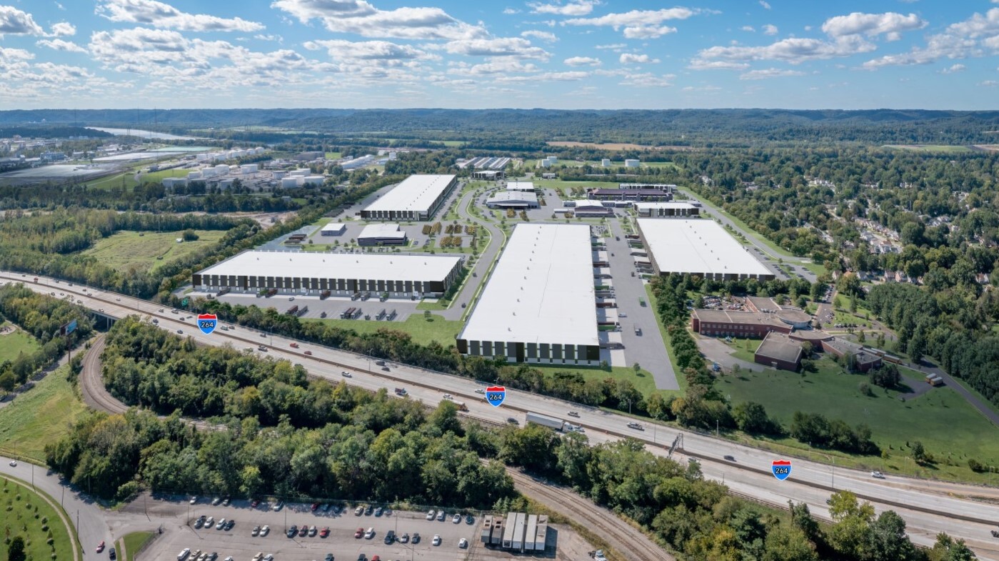
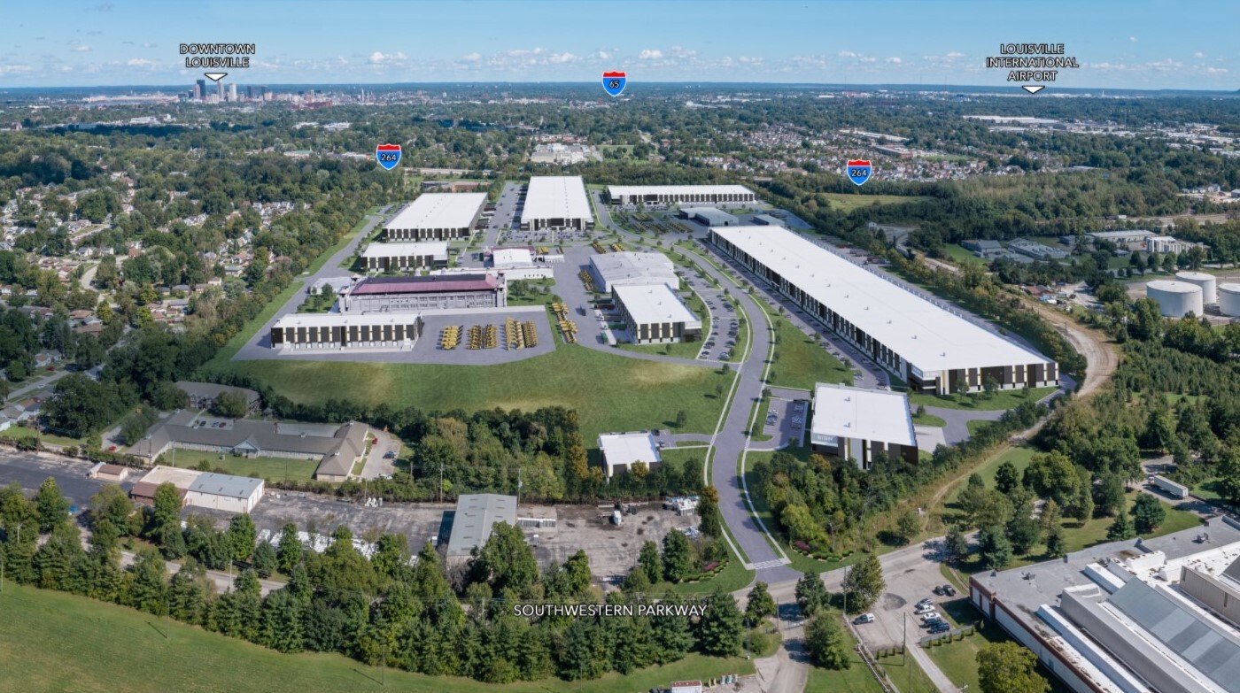
Property Record
1400 Cecil Ave, Louisville, KY 40211
NEARBY LISTINGS FOR SALE OR LEASE
Property Detail
1400 Cecil Ave
Louisville-Jefferson County, KY-IN
Boyd Company Minor Plat
047C00290000
Jefferson
Governmentalpublicusegeneral
Kentucky
X
42.90 AC
21111C0039F
W Outlying Jefferson Cnty
72,905 SF
Louisville
DEMOGRAPHICS near 1400 Cecil Ave
1 Mile
3 Mile
5 Mile
2024 Total Population
9,167
78,753
205,580
2029 Population
9,192
79,052
205,971
Pop Growth 2024-2029
+ 0.27%
+ 0.38%
+ 0.19%
Average Age
38
38
38
2024 Total Households
3,718
31,530
87,556
HH Growth 2024-2029
+ 0.19%
+ 0.36%
+ 0.24%
Median Household Inc
$30,431
$33,658
$37,071
Avg Household Size
2.40
2.40
2.20
2024 Avg HH Vehicles
1.00
1.00
1.00
Median Home Value
$78,082
$88,112
$130,580
Median Year Built
1953
1950
1951
Nearby Places
- Restaurants
- Banks
- Shops
- Fitness
- Groceries
PUBLIC TRANSPORTATION
AIRPORT
Louisville Muhammad Ali International
DRIVE
WALK
Distance
Louisville Muhammad Ali International
20 min
10.1 mi
Freight Ports
Port of Toledo
DRIVE
WALK
Distance
Port of Toledo
366 min
310.5 mi
Nearby Properties
Address
Land Use
TOTAL SIZE
Lot Size
Zoning
Address
Land Use
TOTAL SIZE
Lot Size
Zoning
18.03 AC
Address
Land Use
TOTAL SIZE
Lot Size
Zoning
3,162 SF
23.76 AC
EZ1-ENTERP
Address
Land Use
TOTAL SIZE
Lot Size
Zoning
15.24 AC
Address
Land Use
TOTAL SIZE
Lot Size
Zoning
38.34 AC
Address
Land Use
TOTAL SIZE
Lot Size
Zoning
308 SF
57.16 AC
EZ1-ENTERP
Address
Land Use
TOTAL SIZE
Lot Size
Zoning
270 SF
121 AC
M3-INDUSTR
Address
Land Use
TOTAL SIZE
Lot Size
Zoning
164,677 SF
13.54 AC
EZ1-ENTERP
Address
Land Use
TOTAL SIZE
Lot Size
Zoning
139,200 SF
29.50 AC
EZ1-ENTERP
Address
Land Use
TOTAL SIZE
Lot Size
Zoning
8.74 AC
R7-RESIDEN
Address
Land Use
TOTAL SIZE
Lot Size
Zoning
135,832 SF
5.06 AC
EZ1-ENTERP
Address
Land Use
TOTAL SIZE
Lot Size
Zoning
20,258 SF
60.94 AC
M3-INDUSTR
Address
Land Use
TOTAL SIZE
Lot Size
Zoning
1,440 SF
141.94 AC
M3-INDUSTR
Address
Land Use
TOTAL SIZE
Lot Size
Zoning
1,620 SF
16.84 AC
R6-RESIDEN
Address
Land Use
TOTAL SIZE
Lot Size
Zoning
12.18 AC
EZ1-ENTERP
Address
Land Use
TOTAL SIZE
Lot Size
Zoning
88,320 SF
46.22 AC
EZ1-ENTERP
Address
Land Use
TOTAL SIZE
Lot Size
Zoning
24,839 SF
25.37 AC
M3-INDUSTR
Address
Land Use
TOTAL SIZE
Lot Size
Zoning
266,400 SF
16.40 AC
EZ1-ENTERP
Address
Land Use
TOTAL SIZE
Lot Size
Zoning
133,829 SF
10.03 AC
EZ1-ENTERP
Address
Land Use
TOTAL SIZE
Lot Size
Zoning
8,100 SF
8.59 AC
EZ1-ENTERP
Address
Land Use
TOTAL SIZE
Lot Size
Zoning
14,192 SF
5.26 AC
R6-RESIDEN
Address
Land Use
TOTAL SIZE
Lot Size
Zoning
100,895 SF
7.92 AC
EZ1-ENTERP
Address
Land Use
TOTAL SIZE
Lot Size
Zoning
95,508 SF
3.67 AC
EZ1-ENTERP
Address
Land Use
TOTAL SIZE
Lot Size
Zoning
3,350 SF
8.28 AC
M3-INDUSTR
Address
Land Use
TOTAL SIZE
Lot Size
Zoning
125,842 SF
2.16 AC
EZ1-ENTERP
Address
Land Use
TOTAL SIZE
Lot Size
Zoning
304,575 SF
13.10 AC
M3-INDUSTR
Address
Land Use
TOTAL SIZE
Lot Size
Zoning
44,820 SF
35.72 AC
C3-CENTRAL
Address
Land Use
TOTAL SIZE
Lot Size
Zoning
67,600 SF
6.76 AC
EZ1-ENTERP
Address
Land Use
TOTAL SIZE
Lot Size
Zoning
32,344 SF
7.16 AC
C1-COMMERC
Address
Land Use
TOTAL SIZE
Lot Size
Zoning
28,416 SF
2.05 AC
CM-COMMERC
Address
Land Use
TOTAL SIZE
Lot Size
Zoning
170,301 SF
9.64 AC
CM-COMMERC
The World's #1 Commercial Real Estate Marketplace
Connect with us
© 2025 CoStar Group
The information above has been obtained from sources believed reliable. While we do not doubt its accuracy we have not verified it and make no guarantee, warranty or representation about it. It is your responsibility to independently confirm its accuracy and completeness. Any projections, opinions, assumptions, or estimates used are for example only and do not represent the current or future performance of the property. The value of this transaction to you depends on tax and other factors which should be evaluated by your tax, financial, and legal advisors. You and your advisors should conduct a careful, independent investigation of the property to determine to your satisfaction the suitability of the property for your needs.