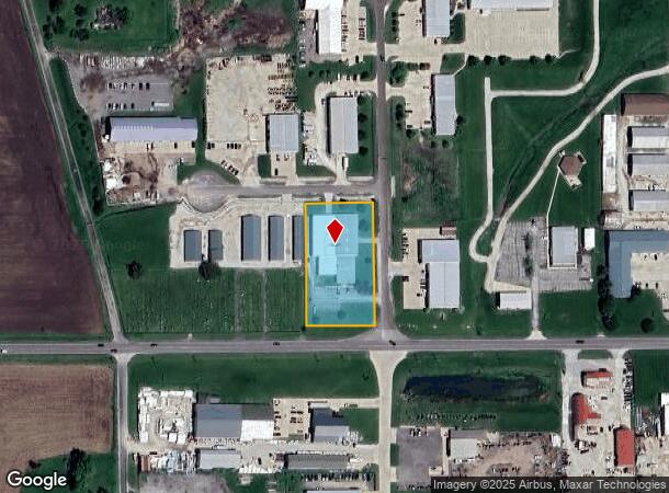
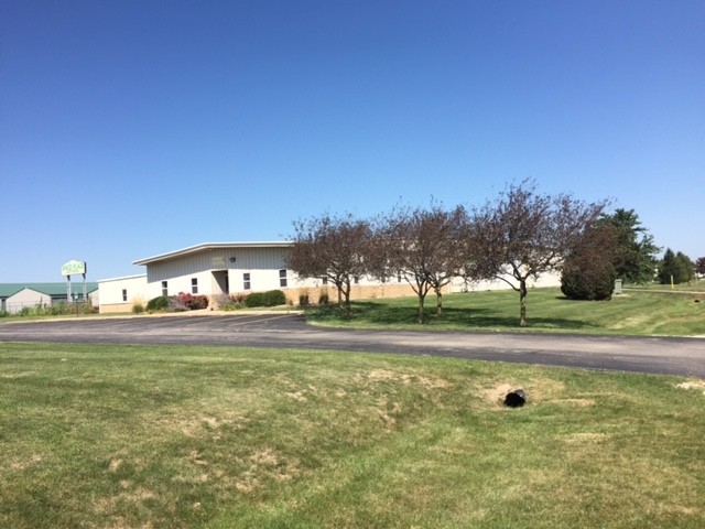
Property Record
14018 Carole Dr, Bloomington, IL 61705

NEARBY LISTINGS FOR SALE OR LEASE
Property Detail
14018 Carole Dr
Bloomington, IL
Don Owens Commercial Sub
13-35-351-009
LOT 13 DON OWENS COMMERCIAL SUB SW 35 & SE 34-24-1E
Commercialnec
Mclean
X
Illinois
17113C0500E
13
2022
1.41 AC
2022
Other Market Areas
005201
DEMOGRAPHICS near 14018 Carole Dr
1 Mile
3 Mile
5 Mile
2024 Total Population
783
3,590
58,649
2029 Population
776
3,561
59,036
Pop Growth 2024-2029
(0.89%)
(0.81%)
+ 0.66%
Average Age
44
41
35
2024 Total Households
301
1,423
22,460
HH Growth 2024-2029
(1.33%)
(0.98%)
+ 0.75%
Median Household Inc
$108,871
$83,088
$47,744
Avg Household Size
2.60
2.50
2.20
2024 Avg HH Vehicles
2.00
2.00
2.00
Median Home Value
$258,762
$234,146
$149,456
Median Year Built
1978
1985
1974
Nearby Places
- Restaurants
- Banks
- Shops
- Fitness
- Groceries
PUBLIC TRANSPORTATION
COMMUTER RAIL
Bloomington-Normal (Lincoln Service - Amtrak, Lincoln Service Missouri River Runner - Amtrak, Texas Eagle - Amtrak)
DRIVE
WALK
Distance
Bloomington-Normal (Lincoln Service - Amtrak, Lincoln Service Missouri River Runner - Amtrak, Texas Eagle - Amtrak)
11 min
6.2 mi
AIRPORT
Central Il Regional/Bloomington-Normal
DRIVE
WALK
Distance
Central Il Regional/Bloomington-Normal
21 min
9.3 mi
Freight Ports
Port Milwaukee
DRIVE
WALK
Distance
Port Milwaukee
247 min
212.2 mi
SALE & LEASE HISTORY
LISTING DATE
SALE/LEASE

Oct 02, 2017
For Lease
Nearby Properties
Address
Land Use
TOTAL SIZE
Lot Size
Zoning
Address
Land Use
TOTAL SIZE
Lot Size
Zoning
417.53 AC
Address
Land Use
TOTAL SIZE
Lot Size
Zoning
432,093 SF
15 AC
Address
Land Use
TOTAL SIZE
Lot Size
Zoning
422,234 SF
23.17 AC
Address
Land Use
TOTAL SIZE
Lot Size
Zoning
196,500 SF
5.07 AC
Address
Land Use
TOTAL SIZE
Lot Size
Zoning
335,377 SF
9.78 AC
Address
Land Use
TOTAL SIZE
Lot Size
Zoning
128,182 SF
10.65 AC
Address
Land Use
TOTAL SIZE
Lot Size
Zoning
126,428 SF
3.79 AC
Address
Land Use
TOTAL SIZE
Lot Size
Zoning
98,824 SF
10.13 AC
Address
Land Use
TOTAL SIZE
Lot Size
Zoning
190,476 SF
14.43 AC
M-1
Address
Land Use
TOTAL SIZE
Lot Size
Zoning
181,476 SF
6.70 AC
Address
Land Use
TOTAL SIZE
Lot Size
Zoning
48,629 SF
39 AC
Address
Land Use
TOTAL SIZE
Lot Size
Zoning
97,000 SF
7 AC
M-2
Address
Land Use
TOTAL SIZE
Lot Size
Zoning
58,904 SF
2.17 AC
Address
Land Use
TOTAL SIZE
Lot Size
Zoning
198,016 SF
15.92 AC
Address
Land Use
TOTAL SIZE
Lot Size
Zoning
56,828 SF
1.82 AC
Address
Land Use
TOTAL SIZE
Lot Size
Zoning
59,071 SF
15.02 AC
Address
Land Use
TOTAL SIZE
Lot Size
Zoning
8.11 AC
Address
Land Use
TOTAL SIZE
Lot Size
Zoning
197,633 SF
11.91 AC
M-1
Address
Land Use
TOTAL SIZE
Lot Size
Zoning
73,207 SF
2.41 AC
Address
Land Use
TOTAL SIZE
Lot Size
Zoning
178,008 SF
13.40 AC
Address
Land Use
TOTAL SIZE
Lot Size
Zoning
51,648 SF
1.61 AC
Address
Land Use
TOTAL SIZE
Lot Size
Zoning
64,959 SF
1.98 AC
Address
Land Use
TOTAL SIZE
Lot Size
Zoning
277,200 SF
38.10 AC
Address
Land Use
TOTAL SIZE
Lot Size
Zoning
23.82 AC
Address
Land Use
TOTAL SIZE
Lot Size
Zoning
42,594 SF
1.20 AC
Address
Land Use
TOTAL SIZE
Lot Size
Zoning
156,520 SF
5.48 AC
Address
Land Use
TOTAL SIZE
Lot Size
Zoning
53,076 SF
3.32 AC
Address
Land Use
TOTAL SIZE
Lot Size
Zoning
93,964 SF
10.57 AC
Address
Land Use
TOTAL SIZE
Lot Size
Zoning
28,296 SF
2.60 AC
Address
Land Use
TOTAL SIZE
Lot Size
Zoning
134,313 SF
5.32 AC
The World's #1 Commercial Real Estate Marketplace
Connect with us
© 2025 CoStar Group
The information above has been obtained from sources believed reliable. While we do not doubt its accuracy we have not verified it and make no guarantee, warranty or representation about it. It is your responsibility to independently confirm its accuracy and completeness. Any projections, opinions, assumptions, or estimates used are for example only and do not represent the current or future performance of the property. The value of this transaction to you depends on tax and other factors which should be evaluated by your tax, financial, and legal advisors. You and your advisors should conduct a careful, independent investigation of the property to determine to your satisfaction the suitability of the property for your needs.