Property Record
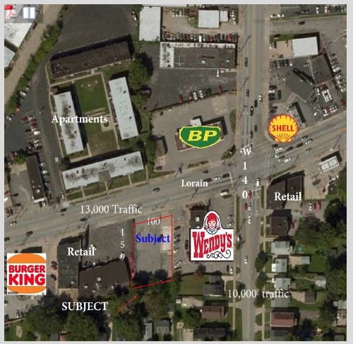
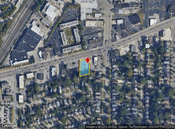
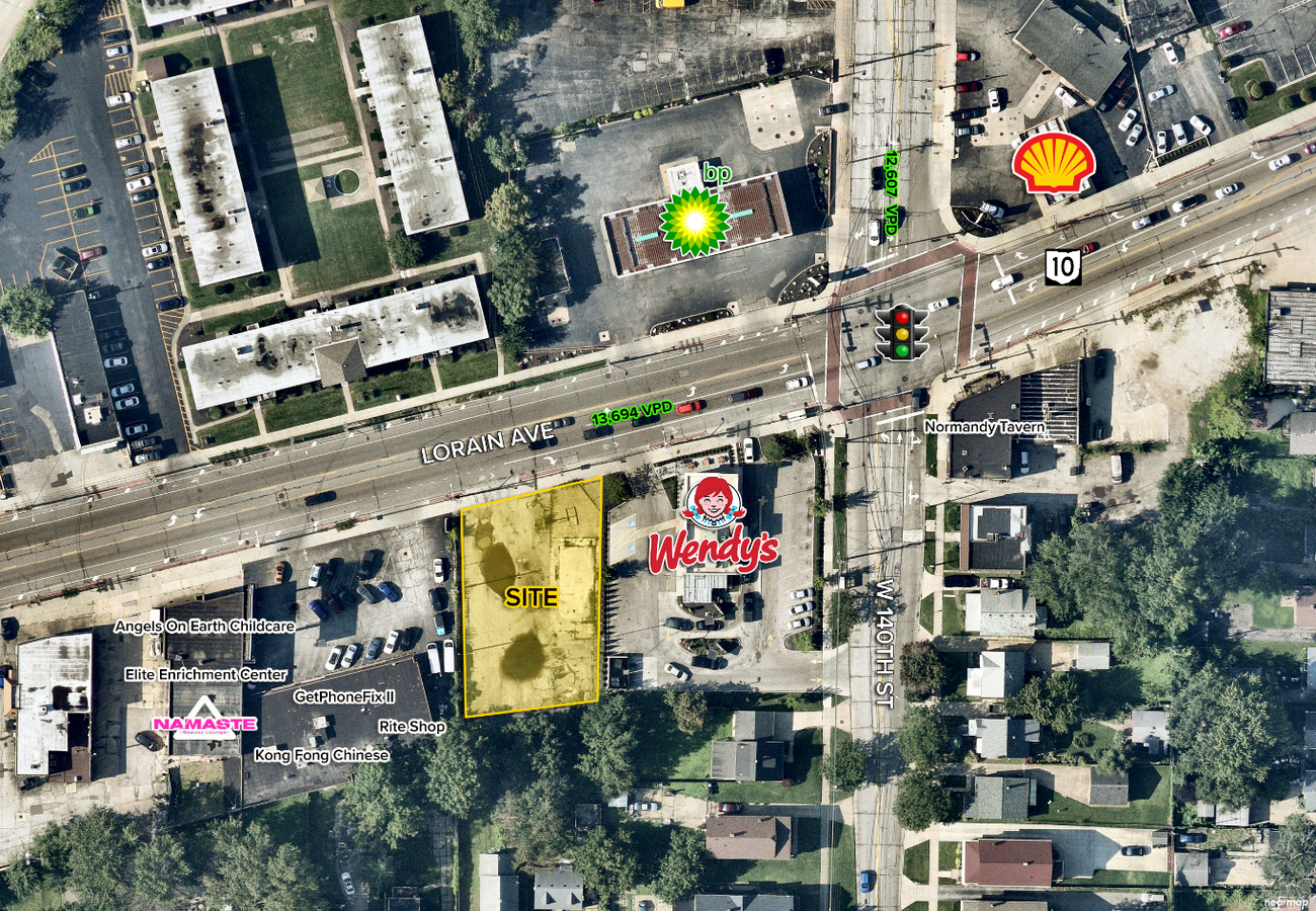
14039 Lorain Ave, Cleveland, OH 44111

Current Lease Availabilities
NEARBY LISTINGS FOR SALE OR LEASE
Property Detail
14039 Lorain Ave
Cleveland
Cook & Beavis West Park
Cleveland-Elyria, OH
12 S/L 4 5 ALL 02201014
022-01-013
Cuyahoga
Parkinglot
Ohio
2024
12
2024
0.40 AC
124201
Southwest
1,320 SF
DEMOGRAPHICS near 14039 Lorain Ave
1 Mile
3 Mile
5 Mile
2024 Total Population
20,226
151,238
297,233
2029 Population
19,482
146,657
287,964
Pop Growth 2024-2029
(3.68%)
(3.03%)
(3.12%)
Average Age
39
39
40
2024 Total Households
8,744
70,623
134,560
HH Growth 2024-2029
(3.89%)
(3.15%)
(3.24%)
Median Household Inc
$50,556
$51,840
$53,596
Avg Household Size
2.20
2.10
2.10
2024 Avg HH Vehicles
2.00
1.00
2.00
Median Home Value
$102,930
$155,322
$156,161
Median Year Built
1947
1948
1950
Nearby Places
- Restaurants
- Banks
- Shops
- Fitness
- Groceries
PUBLIC TRANSPORTATION
TRANSIT/SUBWAY
West Park (Red Line - Greater Cleveland Regional Transit Authority Rapid Transit (The Rapid))
DRIVE
WALK
Distance
West Park (Red Line - Greater Cleveland Regional Transit Authority Rapid Transit (The Rapid))
2 min
9 min
0.5 mi
Triskett (Red Line - Greater Cleveland Regional Transit Authority Rapid Transit (The Rapid))
DRIVE
WALK
Distance
Triskett (Red Line - Greater Cleveland Regional Transit Authority Rapid Transit (The Rapid))
3 min
20 min
1.0 mi
COMMUTER RAIL
Cleveland Lakefront Station (Blue Line - Greater Cleveland Regional Transit Authority Rapid Transit (The Rapid), Green Line - Greater Cleveland Regional Transit Authority Rapid Transit (The Rapid))
DRIVE
WALK
Distance
Cleveland Lakefront Station (Blue Line - Greater Cleveland Regional Transit Authority Rapid Transit (The Rapid), Green Line - Greater Cleveland Regional Transit Authority Rapid Transit (The Rapid))
18 min
9.0 mi
AIRPORT
Cleveland-Hopkins International
DRIVE
WALK
Distance
Cleveland-Hopkins International
14 min
5.5 mi
Freight Ports
Port of Toledo
DRIVE
WALK
Distance
Port of Toledo
128 min
106.4 mi
Nearby Properties
Address
Land Use
TOTAL SIZE
Lot Size
Zoning
Address
Land Use
TOTAL SIZE
Lot Size
Zoning
780,869 SF
14.77 AC
LR
Address
Land Use
TOTAL SIZE
Lot Size
Zoning
187 SF
20.90 AC
PG
Address
Land Use
TOTAL SIZE
Lot Size
Zoning
70.02 AC
GI
Address
Land Use
TOTAL SIZE
Lot Size
Zoning
518,244 SF
21.80 AC
Address
Land Use
TOTAL SIZE
Lot Size
Zoning
208,209 SF
12.10 AC
1F
Address
Land Use
TOTAL SIZE
Lot Size
Zoning
809,240 SF
36.27 AC
L-I
Address
Land Use
TOTAL SIZE
Lot Size
Zoning
340,593 SF
10.10 AC
G-1
Address
Land Use
TOTAL SIZE
Lot Size
Zoning
326,357 SF
6.40 AC
GB
Address
Land Use
TOTAL SIZE
Lot Size
Zoning
168,750 SF
18.55 AC
GI
Address
Land Use
TOTAL SIZE
Lot Size
Zoning
123,130 SF
21.88 AC
GI
Address
Land Use
TOTAL SIZE
Lot Size
Zoning
519,592 SF
69.70 AC
L-I
Address
Land Use
TOTAL SIZE
Lot Size
Zoning
355,242 SF
13.28 AC
RMF-HR
Address
Land Use
TOTAL SIZE
Lot Size
Zoning
25,814 SF
64.97 AC
2F
Address
Land Use
TOTAL SIZE
Lot Size
Zoning
132.06 AC
IA
Address
Land Use
TOTAL SIZE
Lot Size
Zoning
389,067 SF
12.05 AC
A-H
Address
Land Use
TOTAL SIZE
Lot Size
Zoning
128,902 SF
7.12 AC
PD
Address
Land Use
TOTAL SIZE
Lot Size
Zoning
142,740 SF
1.82 AC
MF-2
Address
Land Use
TOTAL SIZE
Lot Size
Zoning
20.99 AC
2F
Address
Land Use
TOTAL SIZE
Lot Size
Zoning
126,661 SF
7.07 AC
PD
Address
Land Use
TOTAL SIZE
Lot Size
Zoning
56,212 SF
2.69 AC
Address
Land Use
TOTAL SIZE
Lot Size
Zoning
278,256 SF
0.81 AC
C1
Address
Land Use
TOTAL SIZE
Lot Size
Zoning
228,712 SF
10.10 AC
C3
Address
Land Use
TOTAL SIZE
Lot Size
Zoning
32,820 SF
3.60 AC
U7-B
Address
Land Use
TOTAL SIZE
Lot Size
Zoning
64,000 SF
4.05 AC
Address
Land Use
TOTAL SIZE
Lot Size
Zoning
181,049 SF
7.76 AC
GI
Address
Land Use
TOTAL SIZE
Lot Size
Zoning
57,744 SF
2.30 AC
Address
Land Use
TOTAL SIZE
Lot Size
Zoning
169,865 SF
28.66 AC
1F
Address
Land Use
TOTAL SIZE
Lot Size
Zoning
137,686 SF
12.02 AC
A-H
Address
Land Use
TOTAL SIZE
Lot Size
Zoning
111,956 SF
210.37 AC
PP
The World's #1 Commercial Real Estate Marketplace
Connect with us
© 2025 CoStar Group
The information above has been obtained from sources believed reliable. While we do not doubt its accuracy we have not verified it and make no guarantee, warranty or representation about it. It is your responsibility to independently confirm its accuracy and completeness. Any projections, opinions, assumptions, or estimates used are for example only and do not represent the current or future performance of the property. The value of this transaction to you depends on tax and other factors which should be evaluated by your tax, financial, and legal advisors. You and your advisors should conduct a careful, independent investigation of the property to determine to your satisfaction the suitability of the property for your needs.