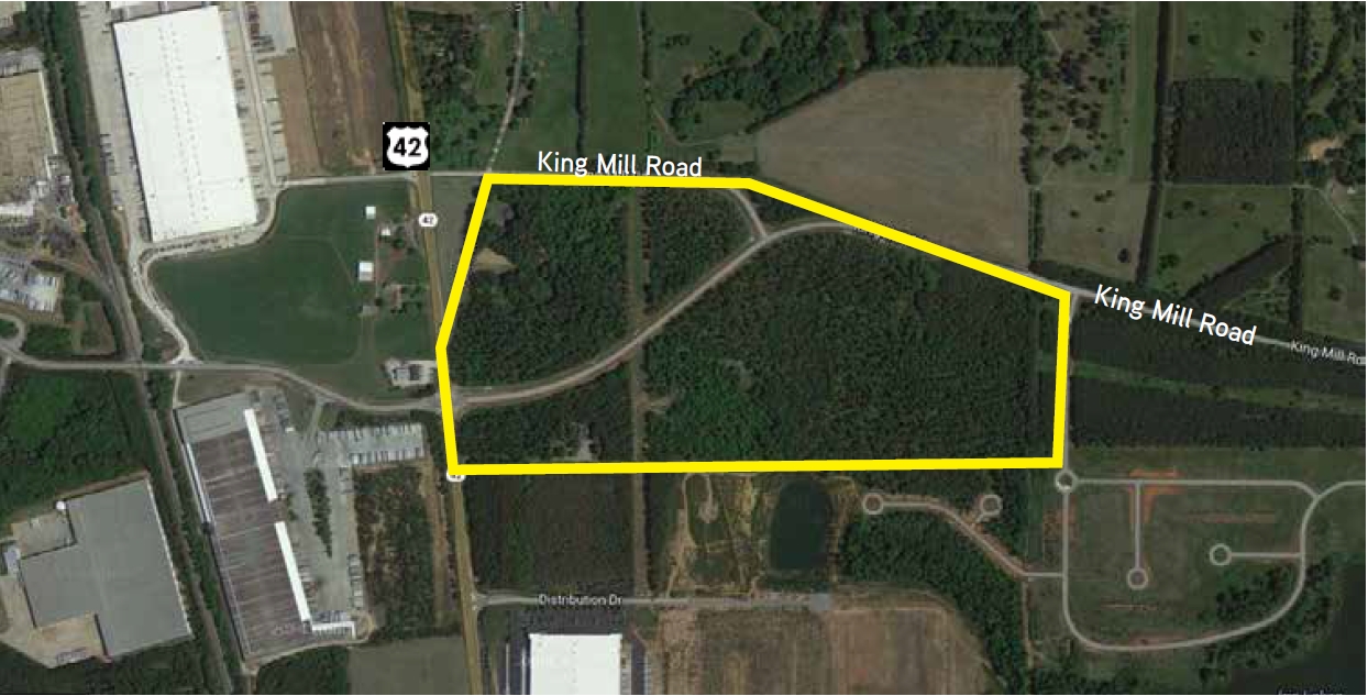
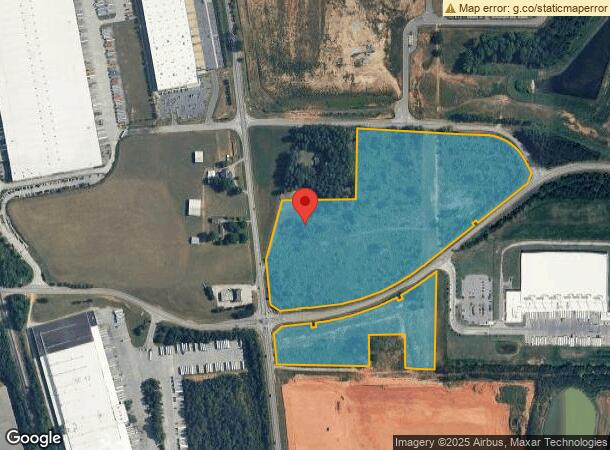
Property Record
283 Highway 42 N, Mcdonough, GA 30253
NEARBY LISTINGS FOR SALE OR LEASE
Property Detail
283 Highway 42 N
0109-01-026-000
LAND LOT: 218 /LAND DISTRICT: 7
Industrialacreage
Henry
X
Georgia
13151C0170D
31.45 AC
2024
South Clayton/Henry Cnty
2024
Atlanta
070317
Atlanta-Sandy Springs-Roswell, GA
742 SF
DEMOGRAPHICS near 283 Highway 42 N
1 Mile
3 Mile
5 Mile
2024 Total Population
664
26,849
80,501
2029 Population
719
29,657
88,485
Pop Growth 2024-2029
+ 8.28%
+ 10.46%
+ 9.92%
Average Age
38
36
37
2024 Total Households
220
9,518
28,388
HH Growth 2024-2029
+ 8.64%
+ 10.61%
+ 10.07%
Median Household Inc
$76,293
$65,564
$71,956
Avg Household Size
3.00
2.80
2.80
2024 Avg HH Vehicles
2.00
2.00
2.00
Median Home Value
$238,095
$237,853
$231,478
Median Year Built
1999
2005
2003
Nearby Places
- Restaurants
- Banks
- Shops
- Fitness
- Groceries
PUBLIC TRANSPORTATION
AIRPORT
Hartsfield - Jackson Atlanta International
DRIVE
WALK
Distance
Hartsfield - Jackson Atlanta International
35 min
26.4 mi
Freight Ports
Georgia Ports - Savannah
DRIVE
WALK
Distance
Georgia Ports - Savannah
243 min
217.6 mi
SALE & LEASE HISTORY
LISTING DATE
SALE/LEASE

Sep 24, 2016
For Sale
Mar 16, 2017
For Sale
Feb 20, 2019
For Sale
Nearby Properties
Address
Land Use
TOTAL SIZE
Lot Size
Zoning
Address
Land Use
TOTAL SIZE
Lot Size
Zoning
1,569,644 SF
84.31 AC
M2
Address
Land Use
TOTAL SIZE
Lot Size
Zoning
754,908 SF
88.41 AC
I
Address
Land Use
TOTAL SIZE
Lot Size
Zoning
900,556 SF
61.08 AC
M
Address
Land Use
TOTAL SIZE
Lot Size
Zoning
31,528 SF
22.04 AC
RMH
Address
Land Use
TOTAL SIZE
Lot Size
Zoning
1,245,868 SF
66.85 AC
M1
Address
Land Use
TOTAL SIZE
Lot Size
Zoning
56.89 AC
M1
Address
Land Use
TOTAL SIZE
Lot Size
Zoning
22,633 SF
31 AC
RM
Address
Land Use
TOTAL SIZE
Lot Size
Zoning
27,336 SF
27.95 AC
Address
Land Use
TOTAL SIZE
Lot Size
Zoning
861,909 SF
44.42 AC
M
Address
Land Use
TOTAL SIZE
Lot Size
Zoning
869,506 SF
59.72 AC
M1
Address
Land Use
TOTAL SIZE
Lot Size
Zoning
728,000 SF
82.62 AC
Address
Land Use
TOTAL SIZE
Lot Size
Zoning
25,622 SF
17.43 AC
RMH
Address
Land Use
TOTAL SIZE
Lot Size
Zoning
760,540 SF
44.93 AC
M2
Address
Land Use
TOTAL SIZE
Lot Size
Zoning
707,997 SF
53.72 AC
C2
Address
Land Use
TOTAL SIZE
Lot Size
Zoning
698,544 SF
44.95 AC
M1
Address
Land Use
TOTAL SIZE
Lot Size
Zoning
247,544 SF
43.30 AC
Address
Land Use
TOTAL SIZE
Lot Size
Zoning
865,642 SF
42.27 AC
M1
Address
Land Use
TOTAL SIZE
Lot Size
Zoning
417,918 SF
41.35 AC
Address
Land Use
TOTAL SIZE
Lot Size
Zoning
712,571 SF
14.22 AC
M1
Address
Land Use
TOTAL SIZE
Lot Size
Zoning
761,930 SF
57.04 AC
M
Address
Land Use
TOTAL SIZE
Lot Size
Zoning
675,238 SF
49.23 AC
M1
Address
Land Use
TOTAL SIZE
Lot Size
Zoning
756,220 SF
43.09 AC
M1
Address
Land Use
TOTAL SIZE
Lot Size
Zoning
40,246 SF
13.73 AC
Address
Land Use
TOTAL SIZE
Lot Size
Zoning
676,198 SF
40.84 AC
M
Address
Land Use
TOTAL SIZE
Lot Size
Zoning
1,111,620 SF
67.79 AC
M2
Address
Land Use
TOTAL SIZE
Lot Size
Zoning
576,975 SF
27.52 AC
M1
Address
Land Use
TOTAL SIZE
Lot Size
Zoning
408,600 SF
33.98 AC
Address
Land Use
TOTAL SIZE
Lot Size
Zoning
438,060 SF
23.17 AC
M1
Address
Land Use
TOTAL SIZE
Lot Size
Zoning
406,942 SF
21.65 AC
M1
Address
Land Use
TOTAL SIZE
Lot Size
Zoning
631,945 SF
53.75 AC
M1
The World's #1 Commercial Real Estate Marketplace
Connect with us
© 2025 CoStar Group
The information above has been obtained from sources believed reliable. While we do not doubt its accuracy we have not verified it and make no guarantee, warranty or representation about it. It is your responsibility to independently confirm its accuracy and completeness. Any projections, opinions, assumptions, or estimates used are for example only and do not represent the current or future performance of the property. The value of this transaction to you depends on tax and other factors which should be evaluated by your tax, financial, and legal advisors. You and your advisors should conduct a careful, independent investigation of the property to determine to your satisfaction the suitability of the property for your needs.