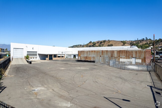
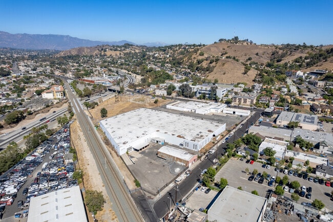
Property Record
141 W Avenue 34, Los Angeles, CA 90031


NEARBY LISTINGS FOR SALE OR LEASE
-
-
-
-
-
-
-
-
-
-
-
No Photo
-
-
-
-
-
-
-
-
View all Los Angeles listings for sale on LoopNet.com
Property Detail
141 W Avenue 34
Los Angeles-Long Beach-Glendale, CA
Parcel Map L A No 541
5205-004-011
*LOT COM AT MOST N COR OF LOT 2 TR NO 23801 TH SE ON NE LINE OF SD LOT 326.55 FT TH S 14 2115" W 140.01 FT TH S 9 4505" W 48.51 FT TH S AND FOLLOWING BDRY LINE OF SD LOT TO W LINE OF LOT GRIFFIN TR AND *POR OF LOT 2 TR NO 23801
Warehouse
Los Angeles
X
California
06037C1629F
2
2022
3.62 AC
2021
Central Los Angeles
199002
Los Angeles
87,980 SF
DEMOGRAPHICS near 141 W Avenue 34
1 Mile
3 Mile
5 Mile
2024 Total Population
29,756
283,883
925,151
2029 Population
28,522
274,130
897,074
Pop Growth 2024-2029
(4.15%)
(3.44%)
(3.03%)
Average Age
39
39
39
2024 Total Households
9,682
96,660
344,962
HH Growth 2024-2029
(4.46%)
(3.67%)
(3.05%)
Median Household Inc
$64,368
$70,713
$64,533
Avg Household Size
2.90
2.70
2.50
2024 Avg HH Vehicles
2.00
2.00
1.00
Median Home Value
$798,865
$808,460
$847,639
Median Year Built
1948
1956
1959
Nearby Places
Map Layers
Map Styles
 Street
 Aerial
- Restaurants
- Banks
- Shops
- Fitness
- Groceries
PUBLIC TRANSPORTATION
TRANSIT/SUBWAY
Heritage Square/Arroyo Station (Gold Line - Los Angeles County Metropolitan Transportation Authority (Metro))
DRIVE
WALK
Distance
Heritage Square/Arroyo Station (Gold Line - Los Angeles County Metropolitan Transportation Authority (Metro))
1 min
8 min
0.3 mi
Lincoln Heights/Cypress Park Station (Gold Line - Los Angeles County Metropolitan Transportation Authority (Metro))
DRIVE
WALK
Distance
Lincoln Heights/Cypress Park Station (Gold Line - Los Angeles County Metropolitan Transportation Authority (Metro))
2 min
10 min
0.5 mi
COMMUTER RAIL
DRIVE
WALK
Distance
7 min
2.7 mi
Union Station (91 Line - Southern California Regional Rail Authority (Metrolink), Antelope Valley Line - Southern California Regional Rail Authority (Metrolink), Orange County Line - Southern California Regional Rail Authority (Metrolink), Riverside Line - Southern California Regional Rail Authority (Metrolink), San Bernardino Line - Southern California Regional Rail Authority (Metrolink), Ventura County Line - Southern California Regional Rail Authority (Metrolink))
DRIVE
WALK
Distance
Union Station (91 Line - Southern California Regional Rail Authority (Metrolink), Antelope Valley Line - Southern California Regional Rail Authority (Metrolink), Orange County Line - Southern California Regional Rail Authority (Metrolink), Riverside Line - Southern California Regional Rail Authority (Metrolink), San Bernardino Line - Southern California Regional Rail Authority (Metrolink), Ventura County Line - Southern California Regional Rail Authority (Metrolink))
9 min
2.8 mi
AIRPORT
Bob Hope
DRIVE
WALK
Distance
Bob Hope
22 min
15.6 mi
Los Angeles International
DRIVE
WALK
Distance
Los Angeles International
30 min
18.1 mi
Long Beach (Daugherty Field)
DRIVE
WALK
Distance
Long Beach (Daugherty Field)
35 min
22.9 mi
Freight Ports
Port of Long Beach
DRIVE
WALK
Distance
Port of Long Beach
36 min
25.8 mi
Nearby Properties
Address
Land Use
TOTAL SIZE
Lot Size
Zoning
Address
Land Use
TOTAL SIZE
Lot Size
Zoning
816,046 SF
15.37 AC
LAA1
Address
Land Use
TOTAL SIZE
Lot Size
Zoning
465,722 SF
5.84 AC
LAC4
Address
Land Use
TOTAL SIZE
Lot Size
Zoning
635,233 SF
12.02 AC
LAR5
Address
Land Use
TOTAL SIZE
Lot Size
Zoning
513,825 SF
4.28 AC
LAC2
Address
Land Use
TOTAL SIZE
Lot Size
Zoning
534,225 SF
Address
Land Use
TOTAL SIZE
Lot Size
Zoning
535,949 SF
5.85 AC
LAM3
Address
Land Use
TOTAL SIZE
Lot Size
Zoning
251,317 SF
114.56 AC
LAR1
Address
Land Use
TOTAL SIZE
Lot Size
Zoning
1,059,650 SF
1.07 AC
LAC2
Address
Land Use
TOTAL SIZE
Lot Size
Zoning
322,080 SF
2.85 AC
LAC2
Address
Land Use
TOTAL SIZE
Lot Size
Zoning
175.69 AC
LAA1
Address
Land Use
TOTAL SIZE
Lot Size
Zoning
328,737 SF
7.92 AC
LAC2
Address
Land Use
TOTAL SIZE
Lot Size
Zoning
642,160 SF
8.26 AC
LAADP
Address
Land Use
TOTAL SIZE
Lot Size
Zoning
368,058 SF
2.65 AC
LAUC (CA)
Address
Land Use
TOTAL SIZE
Lot Size
Zoning
354,299 SF
2.18 AC
LAC2
Address
Land Use
TOTAL SIZE
Lot Size
Zoning
150,608 SF
0.88 AC
LAC2
Address
Land Use
TOTAL SIZE
Lot Size
Zoning
318,903 SF
1.10 AC
LAC4
Address
Land Use
TOTAL SIZE
Lot Size
Zoning
369,452 SF
0.90 AC
LAC2
Address
Land Use
TOTAL SIZE
Lot Size
Zoning
223,783 SF
0.94 AC
LAC2
Address
Land Use
TOTAL SIZE
Lot Size
Zoning
850,903 SF
4.52 AC
LAR5
Address
Land Use
TOTAL SIZE
Lot Size
Zoning
252,825 SF
1.74 AC
LAC2
Address
Land Use
TOTAL SIZE
Lot Size
Zoning
342,600 SF
2.55 AC
LAC4
Address
Land Use
TOTAL SIZE
Lot Size
Zoning
235,102 SF
1.71 AC
LAC2
Address
Land Use
TOTAL SIZE
Lot Size
Zoning
209,559 SF
0.88 AC
LAR5
Address
Land Use
TOTAL SIZE
Lot Size
Zoning
225,923 SF
1.31 AC
LAR5
Address
Land Use
TOTAL SIZE
Lot Size
Zoning
224,969 SF
1.87 AC
LACW
Address
Land Use
TOTAL SIZE
Lot Size
Zoning
266,548 SF
4.59 AC
LAC4
Address
Land Use
TOTAL SIZE
Lot Size
Zoning
119,455 SF
5.04 AC
LACM
Address
Land Use
TOTAL SIZE
Lot Size
Zoning
53,760 SF
4.60 AC
LAM1
Address
Land Use
TOTAL SIZE
Lot Size
Zoning
218,680 SF
1.82 AC
LAR5
Address
Land Use
TOTAL SIZE
Lot Size
Zoning
252,559 SF
2.87 AC
LAC2
The World's #1 Commercial Real Estate Marketplace
Connect with us
© 2026 CoStar Group
The information above has been obtained from sources believed reliable. While we do not doubt its accuracy we have not verified it and make no guarantee, warranty or representation about it. It is your responsibility to independently confirm its accuracy and completeness. Any projections, opinions, assumptions, or estimates used are for example only and do not represent the current or future performance of the property. The value of this transaction to you depends on tax and other factors which should be evaluated by your tax, financial, and legal advisors. You and your advisors should conduct a careful, independent investigation of the property to determine to your satisfaction the suitability of the property for your needs.