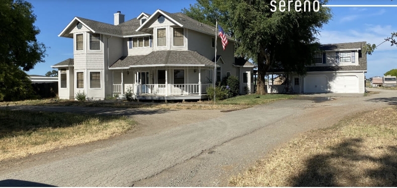
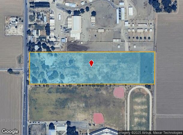
Property Record
14145 Byron Hwy, Byron, CA 94514
NEARBY LISTINGS FOR SALE OR LEASE
Property Detail
14145 Byron Hwy
002-010-005-3
POR SEC 3 T1S R3E
Orchard
Contra Costa
AE
California
06013C0370G
10 AC
2023
Danville/Alamo
2024
East Bay/Oakland
304002
Oakland-Hayward-Berkeley, CA
3,056 SF
DEMOGRAPHICS near 14145 Byron Hwy
1 Mile
3 Mile
5 Mile
2024 Total Population
1,296
11,274
32,861
2029 Population
1,233
11,176
32,679
Pop Growth 2024-2029
(4.86%)
(0.87%)
(0.55%)
Average Age
39
43
41
2024 Total Households
407
4,102
11,392
HH Growth 2024-2029
(5.16%)
(0.63%)
(0.41%)
Median Household Inc
$115,195
$133,548
$135,158
Avg Household Size
3.10
2.70
2.90
2024 Avg HH Vehicles
3.00
2.00
2.00
Median Home Value
$829,113
$819,456
$800,477
Median Year Built
1988
1993
1998
Nearby Places
- Restaurants
- Banks
- Shops
- Fitness
- Groceries
PUBLIC TRANSPORTATION
AIRPORT
Stockton Metro
DRIVE
WALK
Distance
Stockton Metro
39 min
26.4 mi
Freight Ports
Port of Stockton
DRIVE
WALK
Distance
Port of Stockton
35 min
23.9 mi
SALE & LEASE HISTORY
LISTING DATE
SALE/LEASE

Mar 11, 2022
For Lease
Mar 11, 2022
For Sale
Nearby Properties
Address
Land Use
TOTAL SIZE
Lot Size
Zoning
Address
Land Use
TOTAL SIZE
Lot Size
Zoning
48,000 SF
9.98 AC
P1
Address
Land Use
TOTAL SIZE
Lot Size
Zoning
176.43 AC
A3
Address
Land Use
TOTAL SIZE
Lot Size
Zoning
63,600 SF
8.60 AC
Address
Land Use
TOTAL SIZE
Lot Size
Zoning
2,070 SF
5.82 AC
A2
Address
Land Use
TOTAL SIZE
Lot Size
Zoning
55,183 SF
5.45 AC
P1
Address
Land Use
TOTAL SIZE
Lot Size
Zoning
4,548 SF
3.73 AC
P1
Address
Land Use
TOTAL SIZE
Lot Size
Zoning
14,400 SF
5.99 AC
P1
Address
Land Use
TOTAL SIZE
Lot Size
Zoning
2,964 SF
44 AC
A40
Address
Land Use
TOTAL SIZE
Lot Size
Zoning
28,050 SF
2.71 AC
P1
Address
Land Use
TOTAL SIZE
Lot Size
Zoning
18,469 SF
1.84 AC
P1
Address
Land Use
TOTAL SIZE
Lot Size
Zoning
967 SF
154.94 AC
A40
Address
Land Use
TOTAL SIZE
Lot Size
Zoning
50 AC
A2
Address
Land Use
TOTAL SIZE
Lot Size
Zoning
10.88 AC
A3
Address
Land Use
TOTAL SIZE
Lot Size
Zoning
9,075 SF
0.58 AC
P1
Address
Land Use
TOTAL SIZE
Lot Size
Zoning
177.46 AC
A3
Address
Land Use
TOTAL SIZE
Lot Size
Zoning
176.26 AC
A3
Address
Land Use
TOTAL SIZE
Lot Size
Zoning
7,500 SF
0.48 AC
P1
Address
Land Use
TOTAL SIZE
Lot Size
Zoning
8,280 SF
0.56 AC
P1
Address
Land Use
TOTAL SIZE
Lot Size
Zoning
10 AC
A3
Address
Land Use
TOTAL SIZE
Lot Size
Zoning
4,023 SF
5.40 AC
Address
Land Use
TOTAL SIZE
Lot Size
Zoning
5,734 SF
10.46 AC
A2
Address
Land Use
TOTAL SIZE
Lot Size
Zoning
6,816 SF
12.29 AC
A40
Address
Land Use
TOTAL SIZE
Lot Size
Zoning
1,035 SF
115.34 AC
A40
Address
Land Use
TOTAL SIZE
Lot Size
Zoning
6,047 SF
1.01 AC
P1
Address
Land Use
TOTAL SIZE
Lot Size
Zoning
5,172 SF
18.27 AC
A2
Address
Land Use
TOTAL SIZE
Lot Size
Zoning
22,425 SF
67.41 AC
P1
Address
Land Use
TOTAL SIZE
Lot Size
Zoning
7,474 SF
25.32 AC
A40
Address
Land Use
TOTAL SIZE
Lot Size
Zoning
27,090 SF
2.89 AC
C
Address
Land Use
TOTAL SIZE
Lot Size
Zoning
5,266 SF
10.60 AC
A40
Address
Land Use
TOTAL SIZE
Lot Size
Zoning
4,193 SF
10.03 AC
A2
The World's #1 Commercial Real Estate Marketplace
Connect with us
© 2025 CoStar Group
The information above has been obtained from sources believed reliable. While we do not doubt its accuracy we have not verified it and make no guarantee, warranty or representation about it. It is your responsibility to independently confirm its accuracy and completeness. Any projections, opinions, assumptions, or estimates used are for example only and do not represent the current or future performance of the property. The value of this transaction to you depends on tax and other factors which should be evaluated by your tax, financial, and legal advisors. You and your advisors should conduct a careful, independent investigation of the property to determine to your satisfaction the suitability of the property for your needs.