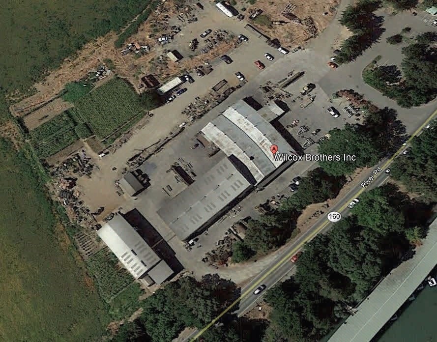
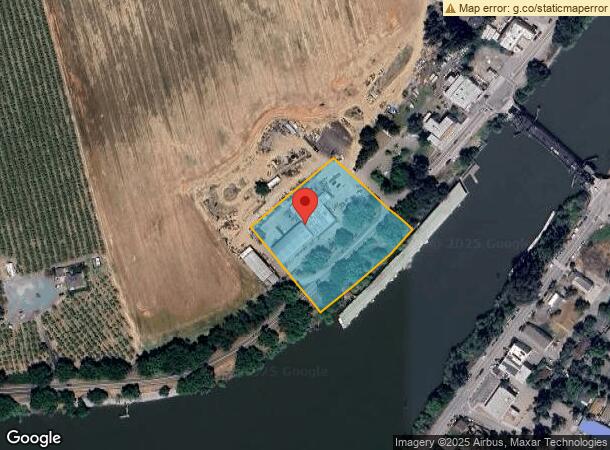
Property Record
14184 State Highway 160, Walnut Grove, CA 95690

NEARBY LISTINGS FOR SALE OR LEASE
-
-
View all Walnut Grove listings for sale on LoopNet.com
Property Detail
14184 State Highway 160
Sacramento--Roseville--Arden-Arcade, CA
Parcel Map
142-0240-002
PARCEL MAP, LOT 2
Cannery
Sacramento
AE
California
06067C0560H
2
2023
2.70 AC
2024
Outer Sacramento Cnty
009900
Sacramento
18,000 SF
DEMOGRAPHICS near 14184 State Highway 160
1 Mile
3 Mile
5 Mile
2024 Total Population
1,147
1,769
2,186
2029 Population
1,075
1,681
2,083
Pop Growth 2024-2029
(6.28%)
(4.97%)
(4.71%)
Average Age
42
42
42
2024 Total Households
425
650
793
HH Growth 2024-2029
(6.35%)
(5.08%)
(4.92%)
Median Household Inc
$64,652
$64,473
$64,500
Avg Household Size
2.60
2.60
2.70
2024 Avg HH Vehicles
2.00
2.00
2.00
Median Home Value
$707,386
$683,139
$677,049
Median Year Built
1957
1964
1964
Nearby Places
- Restaurants
- Banks
- Shops
- Fitness
- Groceries
PUBLIC TRANSPORTATION
AIRPORT
Stockton Metro
DRIVE
WALK
Distance
Stockton Metro
45 min
34.0 mi
Freight Ports
Port of Stockton
DRIVE
WALK
Distance
Port of Stockton
35 min
26.4 mi
SALE & LEASE HISTORY
LISTING DATE
SALE/LEASE

Mar 29, 2019
For Sale
Nearby Properties
Address
Land Use
TOTAL SIZE
Lot Size
Zoning
Address
Land Use
TOTAL SIZE
Lot Size
Zoning
9.07 AC
AG40
Address
Land Use
TOTAL SIZE
Lot Size
Zoning
371.17 AC
AG-80
Address
Land Use
TOTAL SIZE
Lot Size
Zoning
1,687 SF
658.77 AC
AG40
Address
Land Use
TOTAL SIZE
Lot Size
Zoning
6,798 SF
40 AC
AG-80
Address
Land Use
TOTAL SIZE
Lot Size
Zoning
758.84 AC
AG-80
Address
Land Use
TOTAL SIZE
Lot Size
Zoning
2,338 SF
59.20 AC
AG-40
Address
Land Use
TOTAL SIZE
Lot Size
Zoning
3,024 SF
159.63 AC
AG-80
Address
Land Use
TOTAL SIZE
Lot Size
Zoning
2,492 SF
214.26 AC
DW-S AG-80
Address
Land Use
TOTAL SIZE
Lot Size
Zoning
416 AC
AG40
Address
Land Use
TOTAL SIZE
Lot Size
Zoning
161.44 AC
AG-80
Address
Land Use
TOTAL SIZE
Lot Size
Zoning
56,352 SF
9.66 AC
M-2 AG-80
Address
Land Use
TOTAL SIZE
Lot Size
Zoning
768.22 AC
AG-80
Address
Land Use
TOTAL SIZE
Lot Size
Zoning
80 AC
AG-80
Address
Land Use
TOTAL SIZE
Lot Size
Zoning
4,136 SF
24.32 AC
AG-20
Address
Land Use
TOTAL SIZE
Lot Size
Zoning
4.52 AC
M-2
Address
Land Use
TOTAL SIZE
Lot Size
Zoning
4,212 SF
127.77 AC
O AG-80
Address
Land Use
TOTAL SIZE
Lot Size
Zoning
1,548 SF
39.45 AC
AG-20
Address
Land Use
TOTAL SIZE
Lot Size
Zoning
2,939 SF
90 AC
AG-80
Address
Land Use
TOTAL SIZE
Lot Size
Zoning
936 SF
120.76 AC
AG-80
Address
Land Use
TOTAL SIZE
Lot Size
Zoning
58 AC
AG-40
Address
Land Use
TOTAL SIZE
Lot Size
Zoning
512 SF
4.03 AC
AG40
Address
Land Use
TOTAL SIZE
Lot Size
Zoning
40 AC
AG-40 LC
Address
Land Use
TOTAL SIZE
Lot Size
Zoning
111.14 AC
AG-80
Address
Land Use
TOTAL SIZE
Lot Size
Zoning
7,950 SF
35 AC
AG-20
Address
Land Use
TOTAL SIZE
Lot Size
Zoning
5,854 SF
295.09 AC
AG-80
Address
Land Use
TOTAL SIZE
Lot Size
Zoning
89.43 AC
AG-80
Address
Land Use
TOTAL SIZE
Lot Size
Zoning
29,280 SF
5.10 AC
AG-20 M-2
Address
Land Use
TOTAL SIZE
Lot Size
Zoning
64.75 AC
AG-40
Address
Land Use
TOTAL SIZE
Lot Size
Zoning
80.30 AC
AG-80
Address
Land Use
TOTAL SIZE
Lot Size
Zoning
80.19 AC
AG-80
The World's #1 Commercial Real Estate Marketplace
Connect with us
© 2025 CoStar Group
The information above has been obtained from sources believed reliable. While we do not doubt its accuracy we have not verified it and make no guarantee, warranty or representation about it. It is your responsibility to independently confirm its accuracy and completeness. Any projections, opinions, assumptions, or estimates used are for example only and do not represent the current or future performance of the property. The value of this transaction to you depends on tax and other factors which should be evaluated by your tax, financial, and legal advisors. You and your advisors should conduct a careful, independent investigation of the property to determine to your satisfaction the suitability of the property for your needs.