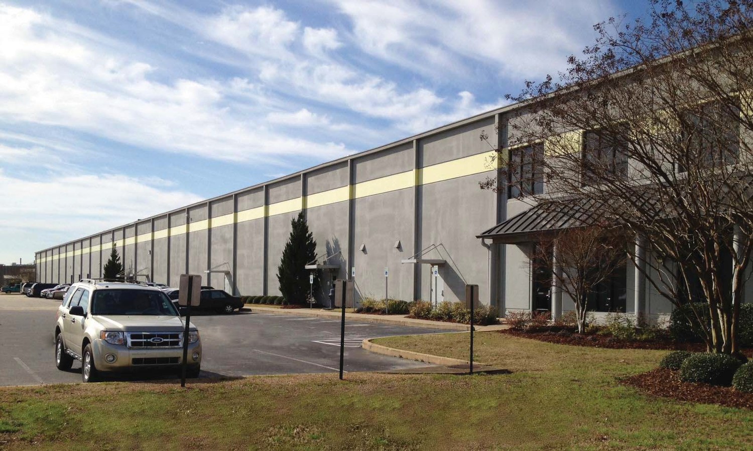
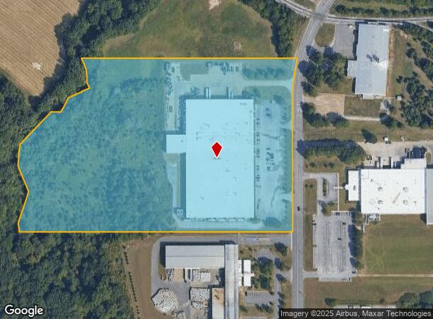
Property Record
1420 Industrial Park Dr, Tuscaloosa, AL 35401
NEARBY LISTINGS FOR SALE OR LEASE
Property Detail
1420 Industrial Park Dr
Tuscaloosa, AL
Tuscaloosa County Industrial Park
31-04-18-3-001-001.002
LOT 7 TUSCALOOSA COUNTY INDUSTRIAL PARK NO 1 SITE A-1 SECT 4
Distributionwarehouseregional
Tuscaloosa
AE
Alabama
01125C0501G
7
2024
21.27 AC
2024
Tuscaloosa
010302
Birmingham
176,846 SF
DEMOGRAPHICS near 1420 Industrial Park Dr
1 Mile
3 Mile
5 Mile
2024 Total Population
767
20,702
76,564
2029 Population
870
23,429
85,973
Pop Growth 2024-2029
+ 13.43%
+ 13.17%
+ 12.29%
Average Age
39
40
35
2024 Total Households
289
7,789
28,018
HH Growth 2024-2029
+ 13.84%
+ 12.94%
+ 14.34%
Median Household Inc
$55,666
$52,103
$42,102
Avg Household Size
2.50
2.40
2.20
2024 Avg HH Vehicles
2.00
2.00
2.00
Median Home Value
$174,596
$179,814
$199,850
Median Year Built
1990
1979
1986
Nearby Places
- Restaurants
- Banks
- Shops
- Fitness
- Groceries
PUBLIC TRANSPORTATION
COMMUTER RAIL
Tuscaloosa Amtrak Station (Crescent - Amtrak)
DRIVE
WALK
Distance
Tuscaloosa Amtrak Station (Crescent - Amtrak)
11 min
6.3 mi
Freight Ports
Port of Mobile
DRIVE
WALK
Distance
Port of Mobile
241 min
200.1 mi
Nearby Properties
Address
Land Use
TOTAL SIZE
Lot Size
Zoning
Address
Land Use
TOTAL SIZE
Lot Size
Zoning
24,360 SF
142 AC
Address
Land Use
TOTAL SIZE
Lot Size
Zoning
174,000 SF
28.67 AC
R1
Address
Land Use
TOTAL SIZE
Lot Size
Zoning
15.30 AC
Address
Land Use
TOTAL SIZE
Lot Size
Zoning
361,935 SF
133.67 AC
MH
Address
Land Use
TOTAL SIZE
Lot Size
Zoning
301,560 SF
15 AC
ML
Address
Land Use
TOTAL SIZE
Lot Size
Zoning
10,852 SF
46 AC
I
Address
Land Use
TOTAL SIZE
Lot Size
Zoning
10,440 SF
12 AC
Address
Land Use
TOTAL SIZE
Lot Size
Zoning
32,640 SF
9.80 AC
C6
Address
Land Use
TOTAL SIZE
Lot Size
Zoning
143,038 SF
36 AC
O-I
Address
Land Use
TOTAL SIZE
Lot Size
Zoning
50,652 SF
19.03 AC
ML
Address
Land Use
TOTAL SIZE
Lot Size
Zoning
91,231 SF
7.71 AC
ML
Address
Land Use
TOTAL SIZE
Lot Size
Zoning
208,996 SF
25 AC
C-6
Address
Land Use
TOTAL SIZE
Lot Size
Zoning
140,412 SF
14.35 AC
C6
Address
Land Use
TOTAL SIZE
Lot Size
Zoning
213,549 SF
8.80 AC
ML
Address
Land Use
TOTAL SIZE
Lot Size
Zoning
108,000 SF
11.87 AC
Address
Land Use
TOTAL SIZE
Lot Size
Zoning
16,920 SF
6.84 AC
AG
Address
Land Use
TOTAL SIZE
Lot Size
Zoning
8,160 SF
3.18 AC
MFH
Address
Land Use
TOTAL SIZE
Lot Size
Zoning
89,820 SF
5.33 AC
MH
Address
Land Use
TOTAL SIZE
Lot Size
Zoning
8,152 SF
18 AC
ML
Address
Land Use
TOTAL SIZE
Lot Size
Zoning
7,376 SF
15 AC
ML
Address
Land Use
TOTAL SIZE
Lot Size
Zoning
8,952 SF
5 AC
RM2
Address
Land Use
TOTAL SIZE
Lot Size
Zoning
11,244 SF
5.60 AC
RM2
Address
Land Use
TOTAL SIZE
Lot Size
Zoning
17,304 SF
7.20 AC
C6
Address
Land Use
TOTAL SIZE
Lot Size
Zoning
7,208 SF
6.10 AC
RM2
Address
Land Use
TOTAL SIZE
Lot Size
Zoning
65,900 SF
3.45 AC
BAN
Address
Land Use
TOTAL SIZE
Lot Size
Zoning
6,882 SF
11.10 AC
RMF1
Address
Land Use
TOTAL SIZE
Lot Size
Zoning
1,800 SF
142 AC
I
Address
Land Use
TOTAL SIZE
Lot Size
Zoning
2,400 SF
11 AC
ML
Address
Land Use
TOTAL SIZE
Lot Size
Zoning
97,250 SF
4.79 AC
ML
The World's #1 Commercial Real Estate Marketplace
Connect with us
© 2025 CoStar Group
The information above has been obtained from sources believed reliable. While we do not doubt its accuracy we have not verified it and make no guarantee, warranty or representation about it. It is your responsibility to independently confirm its accuracy and completeness. Any projections, opinions, assumptions, or estimates used are for example only and do not represent the current or future performance of the property. The value of this transaction to you depends on tax and other factors which should be evaluated by your tax, financial, and legal advisors. You and your advisors should conduct a careful, independent investigation of the property to determine to your satisfaction the suitability of the property for your needs.