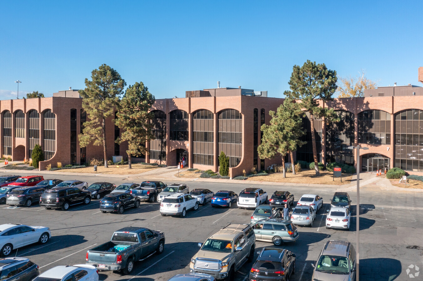
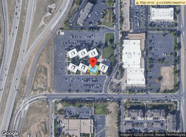
Property Record
14261 E 4Th Ave, Aurora, CO 80011

Current Lease Availabilities
NEARBY LISTINGS FOR SALE OR LEASE
Property Detail
14261 E 4Th Ave
Denver-Aurora-Lakewood, CO
Clock Tower Square Sub 4Th Flg 1St Amend
1975-07-2-21-006
SUBDIVISIONCD 016161 SUBDIVISIONNAME CLOCK TOWER SQUARE SUB 4TH FLG 1ST AMENDMENT BLOCK 001 LOT 006 LOT 6 BLK 1 CLOCK TOWER SQUARE SUB 4TH FLG 1ST AMENDMENT TOG WITH 1/7 INT IN TRACT A
Officebuilding
Arapahoe
X
Colorado
08005C0177L
6
2023
0.19 AC
2024
Aurora
081001
Denver
19,618 SF
DEMOGRAPHICS near 14261 E 4Th Ave
1 Mile
3 Mile
5 Mile
2024 Total Population
19,624
165,682
399,221
2029 Population
19,739
167,966
404,271
Pop Growth 2024-2029
+ 0.59%
+ 1.38%
+ 1.26%
Average Age
35
36
37
2024 Total Households
7,078
59,214
152,427
HH Growth 2024-2029
+ 0.69%
+ 1.41%
+ 1.30%
Median Household Inc
$58,803
$58,277
$66,723
Avg Household Size
2.60
2.60
2.50
2024 Avg HH Vehicles
2.00
2.00
2.00
Median Home Value
$337,299
$349,682
$382,330
Median Year Built
1982
1978
1982
Nearby Places
- Restaurants
- Banks
- Shops
- Fitness
- Groceries
PUBLIC TRANSPORTATION
TRANSIT/SUBWAY
2Nd & Abilene Station (Lincoln Station to Peoria Station - Regional Transportation District)
DRIVE
WALK
Distance
2Nd & Abilene Station (Lincoln Station to Peoria Station - Regional Transportation District)
1 min
8 min
0.4 mi
COMMUTER RAIL
Peoria Station Track 1 (Union Station to Denver Airport Station - Regional Transportation District)
DRIVE
WALK
Distance
Peoria Station Track 1 (Union Station to Denver Airport Station - Regional Transportation District)
9 min
5.2 mi
Peoria Station Track 2 (Union Station to Denver Airport Station - Regional Transportation District)
DRIVE
WALK
Distance
Peoria Station Track 2 (Union Station to Denver Airport Station - Regional Transportation District)
9 min
5.2 mi
AIRPORT
Denver International
DRIVE
WALK
Distance
Denver International
22 min
16.9 mi
Freight Ports
Tulsa Port Of Catoosa
DRIVE
WALK
Distance
Tulsa Port Of Catoosa
718 min
699.5 mi
Nearby Properties
Address
Land Use
TOTAL SIZE
Lot Size
Zoning
Address
Land Use
TOTAL SIZE
Lot Size
Zoning
353,829 SF
4.51 AC
Address
Land Use
TOTAL SIZE
Lot Size
Zoning
368,450 SF
48.59 AC
Address
Land Use
TOTAL SIZE
Lot Size
Zoning
525,050 SF
105.06 AC
Address
Land Use
TOTAL SIZE
Lot Size
Zoning
496,493 SF
33.45 AC
Address
Land Use
TOTAL SIZE
Lot Size
Zoning
868,780 SF
105.02 AC
Address
Land Use
TOTAL SIZE
Lot Size
Zoning
461,580 SF
23.56 AC
Address
Land Use
TOTAL SIZE
Lot Size
Zoning
273,184 SF
1.89 AC
Address
Land Use
TOTAL SIZE
Lot Size
Zoning
557,843 SF
21.35 AC
PUD
Address
Land Use
TOTAL SIZE
Lot Size
Zoning
876,549 SF
46.65 AC
Address
Land Use
TOTAL SIZE
Lot Size
Zoning
140.42 AC
Address
Land Use
TOTAL SIZE
Lot Size
Zoning
315,058 SF
36.85 AC
RPCZD
Address
Land Use
TOTAL SIZE
Lot Size
Zoning
304,620 SF
23.95 AC
AMU
Address
Land Use
TOTAL SIZE
Lot Size
Zoning
672,521 SF
0.61 AC
RB3
Address
Land Use
TOTAL SIZE
Lot Size
Zoning
277,985 SF
19.07 AC
Address
Land Use
TOTAL SIZE
Lot Size
Zoning
178,235 SF
1.38 AC
RFBAD
Address
Land Use
TOTAL SIZE
Lot Size
Zoning
244,920 SF
12.87 AC
Address
Land Use
TOTAL SIZE
Lot Size
Zoning
201,600 SF
44.67 AC
R1
Address
Land Use
TOTAL SIZE
Lot Size
Zoning
269,622 SF
12.90 AC
Address
Land Use
TOTAL SIZE
Lot Size
Zoning
111,358 SF
1.21 AC
Address
Land Use
TOTAL SIZE
Lot Size
Zoning
364,024 SF
23.23 AC
PUD
Address
Land Use
TOTAL SIZE
Lot Size
Zoning
331,923 SF
16.83 AC
Address
Land Use
TOTAL SIZE
Lot Size
Zoning
220,395 SF
7.93 AC
Address
Land Use
TOTAL SIZE
Lot Size
Zoning
366,800 SF
20.21 AC
Address
Land Use
TOTAL SIZE
Lot Size
Zoning
386,285 SF
2.72 AC
Address
Land Use
TOTAL SIZE
Lot Size
Zoning
186,088 SF
10.15 AC
RZIND
Address
Land Use
TOTAL SIZE
Lot Size
Zoning
176,751 SF
28.75 AC
Address
Land Use
TOTAL SIZE
Lot Size
Zoning
326,900 SF
16.21 AC
Address
Land Use
TOTAL SIZE
Lot Size
Zoning
94,638 SF
10.24 AC
R-MU-20
Address
Land Use
TOTAL SIZE
Lot Size
Zoning
521,364 SF
14.88 AC
PUD
Address
Land Use
TOTAL SIZE
Lot Size
Zoning
277,005 SF
16.37 AC
The World's #1 Commercial Real Estate Marketplace
Connect with us
© 2025 CoStar Group
The information above has been obtained from sources believed reliable. While we do not doubt its accuracy we have not verified it and make no guarantee, warranty or representation about it. It is your responsibility to independently confirm its accuracy and completeness. Any projections, opinions, assumptions, or estimates used are for example only and do not represent the current or future performance of the property. The value of this transaction to you depends on tax and other factors which should be evaluated by your tax, financial, and legal advisors. You and your advisors should conduct a careful, independent investigation of the property to determine to your satisfaction the suitability of the property for your needs.