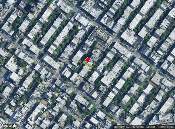
Property Record
1427 Dekalb Ave, Brooklyn, NY 11237
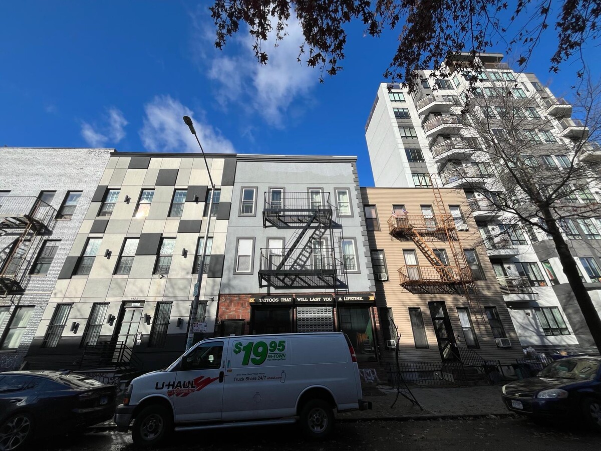

This Property Is For Sale
Current Lease Availabilities
NEARBY LISTINGS FOR SALE OR LEASE
Property Detail
1427 Dekalb Ave
03235-0046
DOCID-2024020100964001
Commercialofficeresidentialmixeduse
Kings
X
New York
3604970208F
46
2024
0.06 AC
2024
Bushwick
042900
Long Island (New York)
5,274 SF
New York-Jersey City-White Plains, NY-NJ
DEMOGRAPHICS near 1427 Dekalb Ave
1 Mile
3 Mile
5 Mile
2024 Total Population
161,609
1,073,474
3,161,683
2029 Population
151,515
1,009,138
2,965,498
Pop Growth 2024-2029
(6.25%)
(5.99%)
(6.21%)
Average Age
36
37
39
2024 Total Households
58,959
405,723
1,276,878
HH Growth 2024-2029
(6.74%)
(6.42%)
(6.43%)
Median Household Inc
$66,157
$69,053
$80,912
Avg Household Size
2.60
2.50
2.40
2024 Avg HH Vehicles
.00
.00
.00
Median Home Value
$914,062
$849,326
$806,913
Median Year Built
1948
1948
1949
Nearby Places
- Restaurants
- Banks
- Shops
- Fitness
- Groceries
PUBLIC TRANSPORTATION
TRANSIT/SUBWAY
Central Avenue (M - New York MTA Subway (The Subway))
DRIVE
WALK
Distance
Central Avenue (M - New York MTA Subway (The Subway))
0 min
4 min
0.3 mi
Knickerbocker Avenue (M Line) (M - New York MTA Subway (The Subway))
DRIVE
WALK
Distance
Knickerbocker Avenue (M Line) (M - New York MTA Subway (The Subway))
1 min
5 min
0.3 mi
Dekalb Avenue (L Line) (L - New York MTA Subway (The Subway))
DRIVE
WALK
Distance
Dekalb Avenue (L Line) (L - New York MTA Subway (The Subway))
1 min
7 min
0.4 mi
Jefferson Street (L - New York MTA Subway (The Subway))
DRIVE
WALK
Distance
Jefferson Street (L - New York MTA Subway (The Subway))
2 min
10 min
0.5 mi
Kosciuszko Street (J - New York MTA Subway (The Subway))
DRIVE
WALK
Distance
Kosciuszko Street (J - New York MTA Subway (The Subway))
3 min
11 min
0.6 mi
COMMUTER RAIL
East New York Station (Far Rockaway Branch - Long Island Rail Road, Long Beach Branch - Long Island Rail Road, West Hempstead Branch - Long Island Rail Road)
DRIVE
WALK
Distance
East New York Station (Far Rockaway Branch - Long Island Rail Road, Long Beach Branch - Long Island Rail Road, West Hempstead Branch - Long Island Rail Road)
6 min
2.7 mi
Nostrand Avenue Station (Far Rockaway Branch - Long Island Rail Road, Hempstead Branch - Long Island Rail Road, Long Beach Branch - Long Island Rail Road, West Hempstead Branch - Long Island Rail Road)
DRIVE
WALK
Distance
Nostrand Avenue Station (Far Rockaway Branch - Long Island Rail Road, Hempstead Branch - Long Island Rail Road, Long Beach Branch - Long Island Rail Road, West Hempstead Branch - Long Island Rail Road)
8 min
2.8 mi
AIRPORT
Laguardia
DRIVE
WALK
Distance
Laguardia
16 min
7.1 mi
John F Kennedy International
DRIVE
WALK
Distance
John F Kennedy International
19 min
11.4 mi
Newark Liberty International
DRIVE
WALK
Distance
Newark Liberty International
31 min
17.0 mi
Freight Ports
NY - Red Hook Container Terminal
DRIVE
WALK
Distance
NY - Red Hook Container Terminal
13 min
5.7 mi
Nearby Properties
Address
Land Use
TOTAL SIZE
Lot Size
Zoning
Address
Land Use
TOTAL SIZE
Lot Size
Zoning
2,812,739 SF
2.10 AC
C5-3
Address
Land Use
TOTAL SIZE
Lot Size
Zoning
296,915 SF
0.31 AC
C5-3
Address
Land Use
TOTAL SIZE
Lot Size
Zoning
383,249 SF
1.32 AC
R6
Address
Land Use
TOTAL SIZE
Lot Size
Zoning
835,231 SF
11.32 AC
R6
Address
Land Use
TOTAL SIZE
Lot Size
Zoning
449,695 SF
0.60 AC
C6-2
Address
Land Use
TOTAL SIZE
Lot Size
Zoning
790,392 SF
0.74 AC
M1-1
Address
Land Use
TOTAL SIZE
Lot Size
Zoning
589,750 SF
1.19 AC
R6
Address
Land Use
TOTAL SIZE
Lot Size
Zoning
522,608 SF
1.64 AC
R8
Address
Land Use
TOTAL SIZE
Lot Size
Zoning
630,112 SF
1.20 AC
R8
Address
Land Use
TOTAL SIZE
Lot Size
Zoning
600,000 SF
2.51 AC
R6B
Address
Land Use
TOTAL SIZE
Lot Size
Zoning
566,000 SF
12.33 AC
R6
Address
Land Use
TOTAL SIZE
Lot Size
Zoning
370,789 SF
0.45 AC
R6B
Address
Land Use
TOTAL SIZE
Lot Size
Zoning
767,750 SF
3.78 AC
C6-4
Address
Land Use
TOTAL SIZE
Lot Size
Zoning
304,080 SF
5.17 AC
M1-2
Address
Land Use
TOTAL SIZE
Lot Size
Zoning
337,880 SF
0.71 AC
R7-2
Address
Land Use
TOTAL SIZE
Lot Size
Zoning
1,119,826 SF
2.76 AC
M1-4
Address
Land Use
TOTAL SIZE
Lot Size
Zoning
1,572,198 SF
22.06 AC
M1-2
Address
Land Use
TOTAL SIZE
Lot Size
Zoning
710,746 SF
1.88 AC
C63A
Address
Land Use
TOTAL SIZE
Lot Size
Zoning
543,250 SF
1.84 AC
R7-3
Address
Land Use
TOTAL SIZE
Lot Size
Zoning
335,000 SF
3.95 AC
R6
Address
Land Use
TOTAL SIZE
Lot Size
Zoning
826,915 SF
8.83 AC
M3-1
Address
Land Use
TOTAL SIZE
Lot Size
Zoning
446,763 SF
12.52 AC
R6
Address
Land Use
TOTAL SIZE
Lot Size
Zoning
363,206 SF
1.38 AC
M12R7A
Address
Land Use
TOTAL SIZE
Lot Size
Zoning
1,150,500 SF
15.17 AC
R6
Address
Land Use
TOTAL SIZE
Lot Size
Zoning
555,920 SF
2.61 AC
M1-2
Address
Land Use
TOTAL SIZE
Lot Size
Zoning
523,000 SF
12 AC
M1-1
Address
Land Use
TOTAL SIZE
Lot Size
Zoning
458,778 SF
2.09 AC
R6
Address
Land Use
TOTAL SIZE
Lot Size
Zoning
485,034 SF
1.84 AC
M1-2
Address
Land Use
TOTAL SIZE
Lot Size
Zoning
409,942 SF
1.56 AC
C6-2
Address
Land Use
TOTAL SIZE
Lot Size
Zoning
228,591 SF
0.82 AC
M1-2
The World's #1 Commercial Real Estate Marketplace
Connect with us
© 2025 CoStar Group
The information above has been obtained from sources believed reliable. While we do not doubt its accuracy we have not verified it and make no guarantee, warranty or representation about it. It is your responsibility to independently confirm its accuracy and completeness. Any projections, opinions, assumptions, or estimates used are for example only and do not represent the current or future performance of the property. The value of this transaction to you depends on tax and other factors which should be evaluated by your tax, financial, and legal advisors. You and your advisors should conduct a careful, independent investigation of the property to determine to your satisfaction the suitability of the property for your needs.