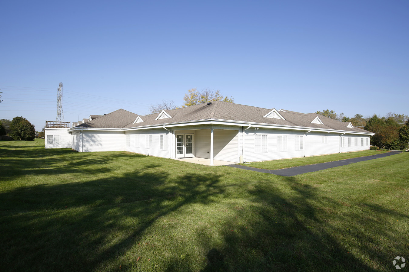
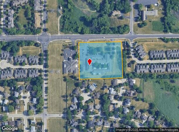
Property Record
1435 Summit St, Elgin, IL 60120


NEARBY LISTINGS FOR SALE OR LEASE
Property Detail
1435 Summit St
Taxexempt
Cook
X
Illinois
17031C0161J
3.52 AC
2021
Far Northwest
2024
Chicago
804404
Chicago-Naperville-Elgin, IL-IN-WI
51,091 SF
06-08-302-037-0000
DEMOGRAPHICS near 1435 Summit St
1 Mile
3 Mile
5 Mile
2024 Total Population
11,778
74,998
185,002
2029 Population
11,320
73,421
181,797
Pop Growth 2024-2029
(3.89%)
(2.10%)
(1.73%)
Average Age
39
38
39
2024 Total Households
3,866
24,825
63,351
HH Growth 2024-2029
(4.24%)
(2.33%)
(1.91%)
Median Household Inc
$85,007
$82,717
$81,399
Avg Household Size
2.90
2.90
2.80
2024 Avg HH Vehicles
2.00
2.00
2.00
Median Home Value
$266,350
$235,527
$238,101
Median Year Built
1990
1977
1976
Nearby Places
- Restaurants
- Banks
- Shops
- Fitness
- Groceries
PUBLIC TRANSPORTATION
COMMUTER RAIL
Elgin Station (Milwaukee District West Line - Northeast Illinois Regional Commuter Railroad (Metra))
DRIVE
WALK
Distance
Elgin Station (Milwaukee District West Line - Northeast Illinois Regional Commuter Railroad (Metra))
8 min
3.5 mi
National Street Station (Milwaukee District West Line - Northeast Illinois Regional Commuter Railroad (Metra))
DRIVE
WALK
Distance
National Street Station (Milwaukee District West Line - Northeast Illinois Regional Commuter Railroad (Metra))
10 min
4.0 mi
AIRPORT
Chicago O'Hare International
DRIVE
WALK
Distance
Chicago O'Hare International
31 min
24.3 mi
Freight Ports
Port Milwaukee
DRIVE
WALK
Distance
Port Milwaukee
109 min
80.5 mi
Nearby Properties
Address
Land Use
TOTAL SIZE
Lot Size
Zoning
Address
Land Use
TOTAL SIZE
Lot Size
Zoning
431,318 SF
20 AC
Address
Land Use
TOTAL SIZE
Lot Size
Zoning
2,415,708 SF
124.06 AC
Address
Land Use
TOTAL SIZE
Lot Size
Zoning
258,989 SF
27.84 AC
Address
Land Use
TOTAL SIZE
Lot Size
Zoning
227,125 SF
2.79 AC
Address
Land Use
TOTAL SIZE
Lot Size
Zoning
176,799 SF
10 AC
Address
Land Use
TOTAL SIZE
Lot Size
Zoning
38,550 SF
0.60 AC
Address
Land Use
TOTAL SIZE
Lot Size
Zoning
93,341 SF
3.67 AC
Address
Land Use
TOTAL SIZE
Lot Size
Zoning
71,725 SF
49.30 AC
Address
Land Use
TOTAL SIZE
Lot Size
Zoning
154,483 SF
10 AC
Address
Land Use
TOTAL SIZE
Lot Size
Zoning
Address
Land Use
TOTAL SIZE
Lot Size
Zoning
123,844 SF
11.51 AC
Address
Land Use
TOTAL SIZE
Lot Size
Zoning
167,166 SF
12.85 AC
Address
Land Use
TOTAL SIZE
Lot Size
Zoning
123,875 SF
10.91 AC
Address
Land Use
TOTAL SIZE
Lot Size
Zoning
120,075 SF
10.70 AC
Address
Land Use
TOTAL SIZE
Lot Size
Zoning
0.32 AC
Address
Land Use
TOTAL SIZE
Lot Size
Zoning
109,316 SF
4.73 AC
Address
Land Use
TOTAL SIZE
Lot Size
Zoning
7.18 AC
Address
Land Use
TOTAL SIZE
Lot Size
Zoning
69,221 SF
3.22 AC
Address
Land Use
TOTAL SIZE
Lot Size
Zoning
1,352 SF
1.27 AC
Address
Land Use
TOTAL SIZE
Lot Size
Zoning
100,804 SF
0.86 AC
Address
Land Use
TOTAL SIZE
Lot Size
Zoning
110,400 SF
5 AC
Address
Land Use
TOTAL SIZE
Lot Size
Zoning
81,989 SF
0.60 AC
Address
Land Use
TOTAL SIZE
Lot Size
Zoning
49,476 SF
4.70 AC
Address
Land Use
TOTAL SIZE
Lot Size
Zoning
21,000 SF
40 AC
Address
Land Use
TOTAL SIZE
Lot Size
Zoning
102,643 SF
10.54 AC
Address
Land Use
TOTAL SIZE
Lot Size
Zoning
Address
Land Use
TOTAL SIZE
Lot Size
Zoning
75,970 SF
5 AC
Address
Land Use
TOTAL SIZE
Lot Size
Zoning
201,539 SF
15.66 AC
Address
Land Use
TOTAL SIZE
Lot Size
Zoning
68,605 SF
9.25 AC
The World's #1 Commercial Real Estate Marketplace
Connect with us
© 2025 CoStar Group
The information above has been obtained from sources believed reliable. While we do not doubt its accuracy we have not verified it and make no guarantee, warranty or representation about it. It is your responsibility to independently confirm its accuracy and completeness. Any projections, opinions, assumptions, or estimates used are for example only and do not represent the current or future performance of the property. The value of this transaction to you depends on tax and other factors which should be evaluated by your tax, financial, and legal advisors. You and your advisors should conduct a careful, independent investigation of the property to determine to your satisfaction the suitability of the property for your needs.