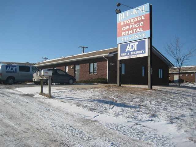
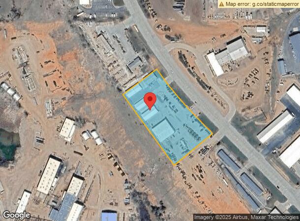
Property Record
1441 Deadwood Ave, Rapid City, SD 57702

NEARBY LISTINGS FOR SALE OR LEASE
Property Detail
1441 Deadwood Ave
0058821
Blu-Knu Subd
Officebuilding
BLU-KNU SUBD, LOT 2
D
Pennington
46103C0757H
South Dakota
2023
2
2024
3.04 AC
011400
Other Market Areas
3,700 SF
Rapid City, SD
DEMOGRAPHICS near 1441 Deadwood Ave
1 Mile
3 Mile
5 Mile
2024 Total Population
307
32,175
72,457
2029 Population
341
35,696
80,466
Pop Growth 2024-2029
+ 11.07%
+ 10.94%
+ 11.05%
Average Age
47
41
41
2024 Total Households
155
13,882
30,636
HH Growth 2024-2029
+ 10.97%
+ 11.29%
+ 11.45%
Median Household Inc
$33,055
$53,459
$59,236
Avg Household Size
1.80
2.10
2.20
2024 Avg HH Vehicles
1.00
2.00
2.00
Median Home Value
$126,666
$240,268
$248,388
Median Year Built
1998
1972
1977
Nearby Places
- Restaurants
- Banks
- Shops
- Fitness
- Groceries
PUBLIC TRANSPORTATION
AIRPORT
Rapid City Regional
DRIVE
WALK
Distance
Rapid City Regional
24 min
13.2 mi
Freight Ports
Tulsa Port Of Catoosa
DRIVE
WALK
Distance
Tulsa Port Of Catoosa
969 min
892.0 mi
Nearby Properties
Address
Land Use
TOTAL SIZE
Lot Size
Zoning
Address
Land Use
TOTAL SIZE
Lot Size
Zoning
5,244 SF
17.53 AC
Address
Land Use
TOTAL SIZE
Lot Size
Zoning
23,278 SF
9.23 AC
Address
Land Use
TOTAL SIZE
Lot Size
Zoning
40,853 SF
8.09 AC
Address
Land Use
TOTAL SIZE
Lot Size
Zoning
50,794 SF
7.05 AC
Address
Land Use
TOTAL SIZE
Lot Size
Zoning
48,204 SF
15.19 AC
Address
Land Use
TOTAL SIZE
Lot Size
Zoning
26,845 SF
3.49 AC
Address
Land Use
TOTAL SIZE
Lot Size
Zoning
7,680 SF
9.34 AC
Address
Land Use
TOTAL SIZE
Lot Size
Zoning
48,084 SF
5.74 AC
Address
Land Use
TOTAL SIZE
Lot Size
Zoning
6,820 SF
10.60 AC
Address
Land Use
TOTAL SIZE
Lot Size
Zoning
10,608 SF
10.90 AC
Address
Land Use
TOTAL SIZE
Lot Size
Zoning
14,360 SF
2.07 AC
Address
Land Use
TOTAL SIZE
Lot Size
Zoning
29,226 SF
1.38 AC
Address
Land Use
TOTAL SIZE
Lot Size
Zoning
50,656 SF
9.17 AC
Address
Land Use
TOTAL SIZE
Lot Size
Zoning
46,025 SF
36.26 AC
Address
Land Use
TOTAL SIZE
Lot Size
Zoning
4,576 SF
4.85 AC
Address
Land Use
TOTAL SIZE
Lot Size
Zoning
10,455 SF
0.24 AC
Address
Land Use
TOTAL SIZE
Lot Size
Zoning
3,703 SF
8.46 AC
Address
Land Use
TOTAL SIZE
Lot Size
Zoning
5,448 SF
7.92 AC
Address
Land Use
TOTAL SIZE
Lot Size
Zoning
95,992 SF
56.73 AC
Address
Land Use
TOTAL SIZE
Lot Size
Zoning
2,058 SF
6.70 AC
Address
Land Use
TOTAL SIZE
Lot Size
Zoning
105,621 SF
10 AC
Address
Land Use
TOTAL SIZE
Lot Size
Zoning
30,740 SF
3.22 AC
Address
Land Use
TOTAL SIZE
Lot Size
Zoning
3,008 SF
4.66 AC
Address
Land Use
TOTAL SIZE
Lot Size
Zoning
19,170 SF
1.83 AC
Address
Land Use
TOTAL SIZE
Lot Size
Zoning
48,786 SF
5 AC
Address
Land Use
TOTAL SIZE
Lot Size
Zoning
144,045 SF
11.96 AC
Address
Land Use
TOTAL SIZE
Lot Size
Zoning
9,395 SF
3.26 AC
Address
Land Use
TOTAL SIZE
Lot Size
Zoning
10,346 SF
1.34 AC
Address
Land Use
TOTAL SIZE
Lot Size
Zoning
2,018 SF
2.42 AC
Address
Land Use
TOTAL SIZE
Lot Size
Zoning
5,412 SF
2.03 AC
The World's #1 Commercial Real Estate Marketplace
Connect with us
© 2025 CoStar Group
The information above has been obtained from sources believed reliable. While we do not doubt its accuracy we have not verified it and make no guarantee, warranty or representation about it. It is your responsibility to independently confirm its accuracy and completeness. Any projections, opinions, assumptions, or estimates used are for example only and do not represent the current or future performance of the property. The value of this transaction to you depends on tax and other factors which should be evaluated by your tax, financial, and legal advisors. You and your advisors should conduct a careful, independent investigation of the property to determine to your satisfaction the suitability of the property for your needs.