Property Record
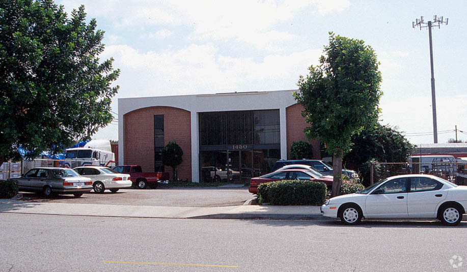
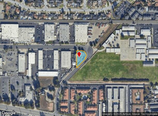
1450 W Industrial Park St, Covina, CA 91722
NEARBY LISTINGS FOR SALE OR LEASE
Property Detail
1450 W Industrial Park St
Los Angeles-Long Beach-Glendale, CA
22341
8434-010-021
*LOT COM AT INTERSECTION OF SW LINE OF INDUSTRIAL PARK ST WITH A LINE PARALLEL WITH AND DIST E AT R/A 17.33 FT FROM E LINE OF LOT 2 TR NO 22341 TH S ON SD PARALLEL LINE TO NW LINE OF CUTTER WAY LOT/SEC 15 BLK/DIV/TWN 1S REG/RNG10
Lightindustrial
Los Angeles
X
California
06037C1700F
2
2024
0.40 AC
2024
Upper San Gabriel Valley
405701
Los Angeles
5,400 SF
DEMOGRAPHICS near 1450 W Industrial Park St
1 Mile
3 Mile
5 Mile
2024 Total Population
24,936
195,241
447,619
2029 Population
23,941
188,082
431,283
Pop Growth 2024-2029
(3.99%)
(3.67%)
(3.65%)
Average Age
40
39
40
2024 Total Households
7,266
55,986
128,705
HH Growth 2024-2029
(4.31%)
(3.91%)
(3.86%)
Median Household Inc
$88,831
$81,712
$85,973
Avg Household Size
3.40
3.40
3.30
2024 Avg HH Vehicles
2.00
2.00
2.00
Median Home Value
$668,494
$669,026
$679,334
Median Year Built
1958
1958
1961
Nearby Places
- Restaurants
- Banks
- Shops
- Fitness
- Groceries
PUBLIC TRANSPORTATION
COMMUTER RAIL
Baldwin Park (San Bernardino Line - Southern California Regional Rail Authority (Metrolink))
DRIVE
WALK
Distance
Baldwin Park (San Bernardino Line - Southern California Regional Rail Authority (Metrolink))
5 min
2.5 mi
Covina (San Bernardino Line - Southern California Regional Rail Authority (Metrolink))
DRIVE
WALK
Distance
Covina (San Bernardino Line - Southern California Regional Rail Authority (Metrolink))
5 min
2.6 mi
AIRPORT
Ontario International
DRIVE
WALK
Distance
Ontario International
28 min
21.4 mi
Long Beach (Daugherty Field)
DRIVE
WALK
Distance
Long Beach (Daugherty Field)
39 min
29.3 mi
Bob Hope
DRIVE
WALK
Distance
Bob Hope
44 min
33.0 mi
Freight Ports
Port of Long Beach
DRIVE
WALK
Distance
Port of Long Beach
46 min
35.0 mi
Nearby Properties
Address
Land Use
TOTAL SIZE
Lot Size
Zoning
Address
Land Use
TOTAL SIZE
Lot Size
Zoning
702,934 SF
16.81 AC
WCCR
Address
Land Use
TOTAL SIZE
Lot Size
Zoning
546,676 SF
6.38 AC
WCCR*
Address
Land Use
TOTAL SIZE
Lot Size
Zoning
836,910 SF
75.03 AC
IRM25*
Address
Land Use
TOTAL SIZE
Lot Size
Zoning
83,337 SF
38.49 AC
WCCR*
Address
Land Use
TOTAL SIZE
Lot Size
Zoning
392,590 SF
21.99 AC
WCOPCC*
Address
Land Use
TOTAL SIZE
Lot Size
Zoning
1,104,998 SF
28 AC
IRM2*
Address
Land Use
TOTAL SIZE
Lot Size
Zoning
221,911 SF
2.24 AC
AZCBD*
Address
Land Use
TOTAL SIZE
Lot Size
Zoning
748,778 SF
11.48 AC
CVC3A*
Address
Land Use
TOTAL SIZE
Lot Size
Zoning
862,213 SF
21.22 AC
WCSP
Address
Land Use
TOTAL SIZE
Lot Size
Zoning
627,908 SF
23.08 AC
IRM1*
Address
Land Use
TOTAL SIZE
Lot Size
Zoning
270,111 SF
12.79 AC
IRM2*
Address
Land Use
TOTAL SIZE
Lot Size
Zoning
119,669 SF
1.56 AC
WCCR*
Address
Land Use
TOTAL SIZE
Lot Size
Zoning
63,919 SF
2.97 AC
CVCP*
Address
Land Use
TOTAL SIZE
Lot Size
Zoning
459,461 SF
1.40 AC
WCCR*
Address
Land Use
TOTAL SIZE
Lot Size
Zoning
294,391 SF
16.90 AC
WCC5*
Address
Land Use
TOTAL SIZE
Lot Size
Zoning
73,908 SF
7.70 AC
IRM1*
Address
Land Use
TOTAL SIZE
Lot Size
Zoning
104,253 SF
2.88 AC
CVRD2000*
Address
Land Use
TOTAL SIZE
Lot Size
Zoning
120,588 SF
4.50 AC
WCR3-MF20*
Address
Land Use
TOTAL SIZE
Lot Size
Zoning
184,800 SF
4.73 AC
CVTCP*
Address
Land Use
TOTAL SIZE
Lot Size
Zoning
105,936 SF
5.24 AC
WCR3-MF20*
Address
Land Use
TOTAL SIZE
Lot Size
Zoning
195,586 SF
2.58 AC
WCCR*
Address
Land Use
TOTAL SIZE
Lot Size
Zoning
109,333 SF
4.30 AC
WCR3-MF20*
Address
Land Use
TOTAL SIZE
Lot Size
Zoning
155,907 SF
4.38 AC
CVR3-RD150
Address
Land Use
TOTAL SIZE
Lot Size
Zoning
163,472 SF
8.40 AC
WCR3-MF20*
Address
Land Use
TOTAL SIZE
Lot Size
Zoning
147,852 SF
5.29 AC
AZM2YY
Address
Land Use
TOTAL SIZE
Lot Size
Zoning
141,174 SF
7.18 AC
WCR3-MF20*
Address
Land Use
TOTAL SIZE
Lot Size
Zoning
113,710 SF
4.95 AC
WCMF20-OP*
Address
Land Use
TOTAL SIZE
Lot Size
Zoning
229,179 SF
13.50 AC
IRM1
Address
Land Use
TOTAL SIZE
Lot Size
Zoning
115,240 SF
4.83 AC
WCMF20-OP*
Address
Land Use
TOTAL SIZE
Lot Size
Zoning
117,847 SF
10 AC
CVC3AY
The World's #1 Commercial Real Estate Marketplace
Connect with us
© 2025 CoStar Group
The information above has been obtained from sources believed reliable. While we do not doubt its accuracy we have not verified it and make no guarantee, warranty or representation about it. It is your responsibility to independently confirm its accuracy and completeness. Any projections, opinions, assumptions, or estimates used are for example only and do not represent the current or future performance of the property. The value of this transaction to you depends on tax and other factors which should be evaluated by your tax, financial, and legal advisors. You and your advisors should conduct a careful, independent investigation of the property to determine to your satisfaction the suitability of the property for your needs.