Property Record
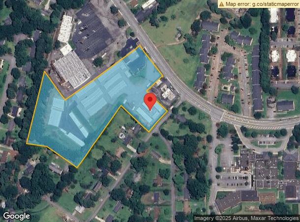
1455 Fernwood Glendale Rd, Spartanburg, SC 29307
NEARBY LISTINGS FOR SALE OR LEASE
Property Detail
1455 Fernwood Glendale Rd
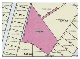
7-13-07-014.01
Revised For Cedar Village Associates
Officebuilding
S SIDE FERNWOOD GLENDALE RD & W OF CLEMSON ST PB 83-437 PB 171-566 DB 113G-840 DB 114N-453 PB 172-69
X
Spartanburg
45083C0259D
South Carolina
2024
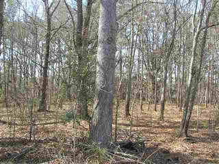
7.70 AC
2023
East Side
022201
Greenville/Spartanburg
1,023 SF
Spartanburg, SC
DEMOGRAPHICS near 1455 Fernwood Glendale Rd
1 Mile
3 Mile
5 Mile
2024 Total Population
4,810
35,280
72,725
2029 Population
5,379
39,719
82,553
Pop Growth 2024-2029
+ 11.83%
+ 12.58%
+ 13.51%
Average Age
43
41
40
2024 Total Households
2,180
15,010
29,639
HH Growth 2024-2029
+ 12.06%
+ 13.15%
+ 13.99%
Median Household Inc
$71,809
$53,855
$46,992
Avg Household Size
2.20
2.20
2.30
2024 Avg HH Vehicles
2.00
2.00
2.00
Median Home Value
$237,857
$199,885
$165,149
Median Year Built
1974
1972
1973
Nearby Places
- Restaurants
- Banks
- Shops
- Fitness
- Groceries
PUBLIC TRANSPORTATION
COMMUTER RAIL
Spartanburg Amtrak Station (Crescent - Amtrak)
DRIVE
WALK
Distance
Spartanburg Amtrak Station (Crescent - Amtrak)
9 min
4.0 mi
AIRPORT
Greenville Spartanburg International
DRIVE
WALK
Distance
Greenville Spartanburg International
38 min
24.7 mi
Freight Ports
North Charleston Terminal
DRIVE
WALK
Distance
North Charleston Terminal
229 min
197.6 mi
Nearby Properties
Address
Land Use
TOTAL SIZE
Lot Size
Zoning
Address
Land Use
TOTAL SIZE
Lot Size
Zoning
9,080 SF
9.06 AC
Address
Land Use
TOTAL SIZE
Lot Size
Zoning
15,108 SF
16.27 AC
Address
Land Use
TOTAL SIZE
Lot Size
Zoning
17,744 SF
3.41 AC
Address
Land Use
TOTAL SIZE
Lot Size
Zoning
893.59 AC
Address
Land Use
TOTAL SIZE
Lot Size
Zoning
106,100 SF
24.56 AC
Address
Land Use
TOTAL SIZE
Lot Size
Zoning
4,598 SF
6.68 AC
Address
Land Use
TOTAL SIZE
Lot Size
Zoning
6,959 SF
51.62 AC
Address
Land Use
TOTAL SIZE
Lot Size
Zoning
1,782 SF
3.50 AC
Address
Land Use
TOTAL SIZE
Lot Size
Zoning
16.45 AC
Address
Land Use
TOTAL SIZE
Lot Size
Zoning
44,199 SF
5.02 AC
Address
Land Use
TOTAL SIZE
Lot Size
Zoning
88.30 AC
Address
Land Use
TOTAL SIZE
Lot Size
Zoning
2,288 SF
8.10 AC
Address
Land Use
TOTAL SIZE
Lot Size
Zoning
49,602 SF
12.95 AC
Address
Land Use
TOTAL SIZE
Lot Size
Zoning
214,026 SF
29.83 AC
Address
Land Use
TOTAL SIZE
Lot Size
Zoning
49,602 SF
4.65 AC
Address
Land Use
TOTAL SIZE
Lot Size
Zoning
25,951 SF
17.61 AC
Address
Land Use
TOTAL SIZE
Lot Size
Zoning
84,960 SF
0.85 AC
Address
Land Use
TOTAL SIZE
Lot Size
Zoning
156,683 SF
11.23 AC
Address
Land Use
TOTAL SIZE
Lot Size
Zoning
3,024 SF
20.77 AC
Address
Land Use
TOTAL SIZE
Lot Size
Zoning
119,443 SF
13.64 AC
Address
Land Use
TOTAL SIZE
Lot Size
Zoning
26,369 SF
3.08 AC
Address
Land Use
TOTAL SIZE
Lot Size
Zoning
66,960 SF
1 AC
Address
Land Use
TOTAL SIZE
Lot Size
Zoning
237.17 AC
Address
Land Use
TOTAL SIZE
Lot Size
Zoning
5,568 SF
0.56 AC
Address
Land Use
TOTAL SIZE
Lot Size
Zoning
522 SF
8.33 AC
Address
Land Use
TOTAL SIZE
Lot Size
Zoning
4,590 SF
10.55 AC
Address
Land Use
TOTAL SIZE
Lot Size
Zoning
1,300 SF
16.20 AC
Address
Land Use
TOTAL SIZE
Lot Size
Zoning
4,007 SF
0.31 AC
Address
Land Use
TOTAL SIZE
Lot Size
Zoning
148,200 SF
7.46 AC
Address
Land Use
TOTAL SIZE
Lot Size
Zoning
98,185 SF
8.95 AC
The World's #1 Commercial Real Estate Marketplace
Connect with us
© 2025 CoStar Group
The information above has been obtained from sources believed reliable. While we do not doubt its accuracy we have not verified it and make no guarantee, warranty or representation about it. It is your responsibility to independently confirm its accuracy and completeness. Any projections, opinions, assumptions, or estimates used are for example only and do not represent the current or future performance of the property. The value of this transaction to you depends on tax and other factors which should be evaluated by your tax, financial, and legal advisors. You and your advisors should conduct a careful, independent investigation of the property to determine to your satisfaction the suitability of the property for your needs.