Property Record
14770 Lindy Dr, Granger, IN 46530
NEARBY LISTINGS FOR SALE OR LEASE
Property Detail
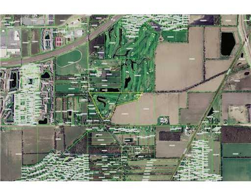
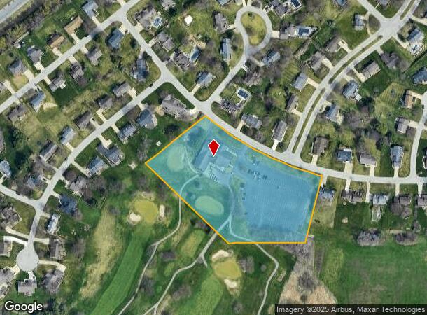
14770 Lindy Dr
71-04-26-176-001.000-011
Juday Creek
Golfcourse
IRREG TRACTS JUDAY CREEK GOLF COURSE EX PARTS SOLD 19/20 NP #852 5/11/18 18/19 SPLIT DOC #1718763, TR# 15970 7/18/2017 TO 006-1011-013182 06-07 CONS W/06-1011-013001, 06-1011-013102, 06-1011-013665, 06-1011-0139, 06-1011-014001, 06-1012-015201 PER OW
X
St Joseph
18141C0207D
Indiana
2022
5.23 AC
2023
Outlying St Joseph County
011406
South Bend/Mishawaka
19,288 SF
South Bend-Mishawaka, IN-MI
DEMOGRAPHICS near 14770 Lindy Dr
1 Mile
3 Mile
5 Mile
2024 Total Population
4,846
41,632
136,976
2029 Population
4,803
41,254
136,463
Pop Growth 2024-2029
(0.89%)
(0.91%)
(0.37%)
Average Age
40
40
39
2024 Total Households
2,273
17,790
54,282
HH Growth 2024-2029
(0.70%)
(0.88%)
(0.29%)
Median Household Inc
$69,723
$63,534
$65,487
Avg Household Size
2.00
2.30
2.30
2024 Avg HH Vehicles
2.00
2.00
2.00
Median Home Value
$242,857
$213,615
$180,068
Median Year Built
1990
1981
1973
Nearby Places
- Restaurants
- Banks
- Shops
- Fitness
- Groceries
PUBLIC TRANSPORTATION
COMMUTER RAIL
South Bend Amtrak Station (Capitol Limited - Amtrak, Lake Shore Limited - Amtrak)
DRIVE
WALK
Distance
South Bend Amtrak Station (Capitol Limited - Amtrak, Lake Shore Limited - Amtrak)
21 min
9.2 mi
AIRPORT
South Bend International
DRIVE
WALK
Distance
South Bend International
32 min
17.6 mi
Freight Ports
Port Milwaukee
DRIVE
WALK
Distance
Port Milwaukee
222 min
185.2 mi
Nearby Properties
Address
Land Use
TOTAL SIZE
Lot Size
Zoning
Address
Land Use
TOTAL SIZE
Lot Size
Zoning
625,641 SF
89.04 AC
Address
Land Use
TOTAL SIZE
Lot Size
Zoning
529,154 SF
30.30 AC
Address
Land Use
TOTAL SIZE
Lot Size
Zoning
276,540 SF
13.81 AC
Address
Land Use
TOTAL SIZE
Lot Size
Zoning
276,683 SF
30.53 AC
Address
Land Use
TOTAL SIZE
Lot Size
Zoning
254,564 SF
Address
Land Use
TOTAL SIZE
Lot Size
Zoning
599,502 SF
39.10 AC
Address
Land Use
TOTAL SIZE
Lot Size
Zoning
239,363 SF
8.26 AC
Address
Land Use
TOTAL SIZE
Lot Size
Zoning
195,495 SF
17.90 AC
Address
Land Use
TOTAL SIZE
Lot Size
Zoning
410,568 SF
29.14 AC
Address
Land Use
TOTAL SIZE
Lot Size
Zoning
146,854 SF
11.57 AC
Address
Land Use
TOTAL SIZE
Lot Size
Zoning
18,028 SF
80.67 AC
Address
Land Use
TOTAL SIZE
Lot Size
Zoning
331,913 SF
30 AC
Address
Land Use
TOTAL SIZE
Lot Size
Zoning
146,337 SF
20.82 AC
Address
Land Use
TOTAL SIZE
Lot Size
Zoning
347,751 SF
32.52 AC
Address
Land Use
TOTAL SIZE
Lot Size
Zoning
192,770 SF
12.21 AC
Address
Land Use
TOTAL SIZE
Lot Size
Zoning
360,056 SF
19.59 AC
Address
Land Use
TOTAL SIZE
Lot Size
Zoning
124,260 SF
5.68 AC
Address
Land Use
TOTAL SIZE
Lot Size
Zoning
87,409 SF
15.88 AC
Address
Land Use
TOTAL SIZE
Lot Size
Zoning
147,760 SF
17.87 AC
Address
Land Use
TOTAL SIZE
Lot Size
Zoning
218,000 SF
24.56 AC
Address
Land Use
TOTAL SIZE
Lot Size
Zoning
148,214 SF
18.11 AC
Address
Land Use
TOTAL SIZE
Lot Size
Zoning
85,367 SF
5.67 AC
Address
Land Use
TOTAL SIZE
Lot Size
Zoning
583,276 SF
40 AC
Address
Land Use
TOTAL SIZE
Lot Size
Zoning
54,226 SF
4.65 AC
Address
Land Use
TOTAL SIZE
Lot Size
Zoning
100,347 SF
8.92 AC
Address
Land Use
TOTAL SIZE
Lot Size
Zoning
88,854 SF
10.32 AC
Address
Land Use
TOTAL SIZE
Lot Size
Zoning
125,887 SF
14.79 AC
Address
Land Use
TOTAL SIZE
Lot Size
Zoning
173,400 SF
10.73 AC
Address
Land Use
TOTAL SIZE
Lot Size
Zoning
151,068 SF
10.32 AC
Address
Land Use
TOTAL SIZE
Lot Size
Zoning
172,995 SF
14.43 AC
The World's #1 Commercial Real Estate Marketplace
Connect with us
© 2025 CoStar Group
The information above has been obtained from sources believed reliable. While we do not doubt its accuracy we have not verified it and make no guarantee, warranty or representation about it. It is your responsibility to independently confirm its accuracy and completeness. Any projections, opinions, assumptions, or estimates used are for example only and do not represent the current or future performance of the property. The value of this transaction to you depends on tax and other factors which should be evaluated by your tax, financial, and legal advisors. You and your advisors should conduct a careful, independent investigation of the property to determine to your satisfaction the suitability of the property for your needs.