Property Record
14940 Spencer St, Omaha, NE 68116
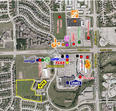
NEARBY LISTINGS FOR SALE OR LEASE
Property Detail
14940 Spencer St
Omaha-Council Bluffs, NE-IA
Belle Meade
0100-0032-06
BELLE MEADE REPLAT 1 LOT 2 BLOCK 0 IRREG 9.11 AC
Commercialnec
Douglas
X
Nebraska
31055C0192H
2
2023
9.11 AC
2023
Northwest Omaha
007469
Omaha/Council Bluffs
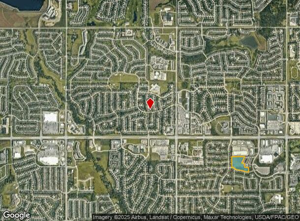
DEMOGRAPHICS near 14940 Spencer St
1 Mile
3 Mile
5 Mile
2024 Total Population
13,208
84,205
202,055
2029 Population
13,256
85,430
205,167
Pop Growth 2024-2029
+ 0.36%
+ 1.45%
+ 1.54%
Average Age
39
39
39
2024 Total Households
5,478
32,000
79,849
HH Growth 2024-2029
+ 0.40%
+ 1.40%
+ 1.49%
Median Household Inc
$86,036
$107,853
$92,014
Avg Household Size
2.40
2.60
2.50
2024 Avg HH Vehicles
2.00
2.00
2.00
Median Home Value
$255,890
$280,986
$274,844
Median Year Built
1996
1997
1992
Nearby Places
- Restaurants
- Banks
- Shops
- Fitness
- Groceries
PUBLIC TRANSPORTATION
AIRPORT
Eppley Airfield
DRIVE
WALK
Distance
Eppley Airfield
32 min
17.1 mi
Freight Ports
Tulsa Port Of Catoosa
DRIVE
WALK
Distance
Tulsa Port Of Catoosa
482 min
432.2 mi
Nearby Properties
Address
Land Use
TOTAL SIZE
Lot Size
Zoning
Address
Land Use
TOTAL SIZE
Lot Size
Zoning
443,045 SF
22.82 AC
Address
Land Use
TOTAL SIZE
Lot Size
Zoning
396,428 SF
14.45 AC
R6
Address
Land Use
TOTAL SIZE
Lot Size
Zoning
420,483 SF
18.51 AC
R6
Address
Land Use
TOTAL SIZE
Lot Size
Zoning
239,976 SF
20.12 AC
Address
Land Use
TOTAL SIZE
Lot Size
Zoning
311,856 SF
19.22 AC
Address
Land Use
TOTAL SIZE
Lot Size
Zoning
250,386 SF
17.06 AC
Address
Land Use
TOTAL SIZE
Lot Size
Zoning
428,342 SF
18.62 AC
Address
Land Use
TOTAL SIZE
Lot Size
Zoning
233,882 SF
9.48 AC
MU
Address
Land Use
TOTAL SIZE
Lot Size
Zoning
339,557 SF
12.89 AC
R7
Address
Land Use
TOTAL SIZE
Lot Size
Zoning
350,925 SF
12.71 AC
Address
Land Use
TOTAL SIZE
Lot Size
Zoning
255,483 SF
14.25 AC
Address
Land Use
TOTAL SIZE
Lot Size
Zoning
184,930 SF
7.96 AC
Address
Land Use
TOTAL SIZE
Lot Size
Zoning
200,114 SF
7.36 AC
Address
Land Use
TOTAL SIZE
Lot Size
Zoning
87,510 SF
6.17 AC
Address
Land Use
TOTAL SIZE
Lot Size
Zoning
261,247 SF
13.20 AC
Address
Land Use
TOTAL SIZE
Lot Size
Zoning
121,017 SF
13.23 AC
Address
Land Use
TOTAL SIZE
Lot Size
Zoning
314,690 SF
11.95 AC
Address
Land Use
TOTAL SIZE
Lot Size
Zoning
168,896 SF
8.79 AC
MU
Address
Land Use
TOTAL SIZE
Lot Size
Zoning
136,340 SF
7.50 AC
MU
Address
Land Use
TOTAL SIZE
Lot Size
Zoning
142,950 SF
5.94 AC
Address
Land Use
TOTAL SIZE
Lot Size
Zoning
99,347 SF
4.50 AC
Address
Land Use
TOTAL SIZE
Lot Size
Zoning
108,211 SF
6.53 AC
Address
Land Use
TOTAL SIZE
Lot Size
Zoning
107,052 SF
5.55 AC
Address
Land Use
TOTAL SIZE
Lot Size
Zoning
96,764 SF
5.48 AC
MU
Address
Land Use
TOTAL SIZE
Lot Size
Zoning
135,576 SF
6.44 AC
R7
Address
Land Use
TOTAL SIZE
Lot Size
Zoning
219,265 SF
13.48 AC
Address
Land Use
TOTAL SIZE
Lot Size
Zoning
125,313 SF
5.52 AC
R6
Address
Land Use
TOTAL SIZE
Lot Size
Zoning
63,614 SF
2.32 AC
Address
Land Use
TOTAL SIZE
Lot Size
Zoning
136,279 SF
5.65 AC
Address
Land Use
TOTAL SIZE
Lot Size
Zoning
143,575 SF
7.58 AC
The World's #1 Commercial Real Estate Marketplace
Connect with us
© 2025 CoStar Group
The information above has been obtained from sources believed reliable. While we do not doubt its accuracy we have not verified it and make no guarantee, warranty or representation about it. It is your responsibility to independently confirm its accuracy and completeness. Any projections, opinions, assumptions, or estimates used are for example only and do not represent the current or future performance of the property. The value of this transaction to you depends on tax and other factors which should be evaluated by your tax, financial, and legal advisors. You and your advisors should conduct a careful, independent investigation of the property to determine to your satisfaction the suitability of the property for your needs.