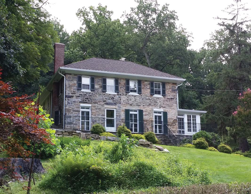
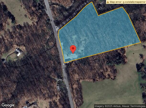
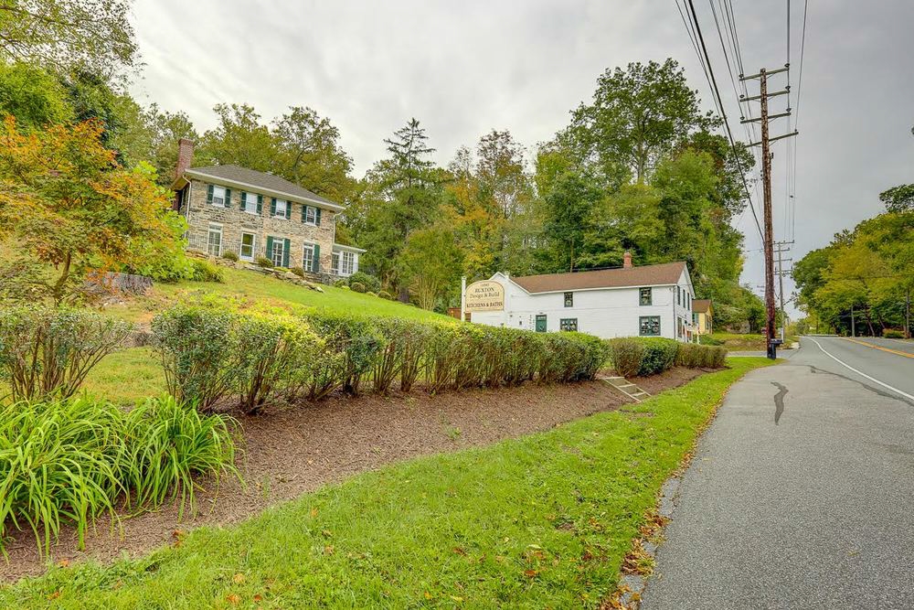
Property Record
14943 York Rd, Sparks Glencoe, MD 21152

NEARBY LISTINGS FOR SALE OR LEASE
-
-
View all Sparks Glencoe listings for sale on LoopNet.com
Property Detail
14943 York Rd
08-0818047501
10.3215 AC
Commercialnec
Baltimore
X
Maryland
2400100120G
10.32 AC
2024
Route 83 Corridor North
2024
Baltimore
408100
Baltimore-Columbia-Towson, MD
9,069 SF
DEMOGRAPHICS near 14943 York Rd
1 Mile
3 Mile
5 Mile
2024 Total Population
673
10,892
32,482
2029 Population
670
10,810
32,049
Pop Growth 2024-2029
(0.45%)
(0.75%)
(1.33%)
Average Age
45
45
42
2024 Total Households
234
4,459
13,164
HH Growth 2024-2029
(0.43%)
(0.70%)
(1.33%)
Median Household Inc
$197,726
$125,321
$107,777
Avg Household Size
2.60
2.30
2.40
2024 Avg HH Vehicles
2.00
2.00
2.00
Median Home Value
$641,221
$474,999
$465,973
Median Year Built
1990
1988
1979
Nearby Places
- Restaurants
- Banks
- Shops
- Fitness
- Groceries
PUBLIC TRANSPORTATION
AIRPORT
Baltimore/Washington International Thurgood Marshall
DRIVE
WALK
Distance
Baltimore/Washington International Thurgood Marshall
48 min
32.3 mi
Freight Ports
Port of Baltimore
DRIVE
WALK
Distance
Port of Baltimore
42 min
24.0 mi
Nearby Properties
Address
Land Use
TOTAL SIZE
Lot Size
Zoning
Address
Land Use
TOTAL SIZE
Lot Size
Zoning
513,056 SF
55.49 AC
BM
Address
Land Use
TOTAL SIZE
Lot Size
Zoning
343,606 SF
19.65 AC
Address
Land Use
TOTAL SIZE
Lot Size
Zoning
595,100 SF
5.73 AC
Address
Land Use
TOTAL SIZE
Lot Size
Zoning
489,483 SF
84.32 AC
RC4
Address
Land Use
TOTAL SIZE
Lot Size
Zoning
330,802 SF
14.81 AC
ML-IM
Address
Land Use
TOTAL SIZE
Lot Size
Zoning
250,462 SF
185.60 AC
Address
Land Use
TOTAL SIZE
Lot Size
Zoning
218,049 SF
22.47 AC
Address
Land Use
TOTAL SIZE
Lot Size
Zoning
371,059 SF
14.11 AC
01
Address
Land Use
TOTAL SIZE
Lot Size
Zoning
418,286 SF
22.60 AC
ML
Address
Land Use
TOTAL SIZE
Lot Size
Zoning
130,720 SF
10.48 AC
ML
Address
Land Use
TOTAL SIZE
Lot Size
Zoning
222,264 SF
5.70 AC
OT
Address
Land Use
TOTAL SIZE
Lot Size
Zoning
289,231 SF
10.23 AC
ML
Address
Land Use
TOTAL SIZE
Lot Size
Zoning
10.61 AC
DR5.5
Address
Land Use
TOTAL SIZE
Lot Size
Zoning
287,690 SF
8.69 AC
MLR
Address
Land Use
TOTAL SIZE
Lot Size
Zoning
44,304 SF
11.98 AC
ML
Address
Land Use
TOTAL SIZE
Lot Size
Zoning
94,993 SF
11.93 AC
BR
Address
Land Use
TOTAL SIZE
Lot Size
Zoning
97,489 SF
8.10 AC
ML
Address
Land Use
TOTAL SIZE
Lot Size
Zoning
8.28 AC
DR5.5
Address
Land Use
TOTAL SIZE
Lot Size
Zoning
39,742 SF
6.80 AC
ML
Address
Land Use
TOTAL SIZE
Lot Size
Zoning
164,767 SF
7.03 AC
MLR
Address
Land Use
TOTAL SIZE
Lot Size
Zoning
82,970 SF
5.27 AC
MLR
Address
Land Use
TOTAL SIZE
Lot Size
Zoning
188,071 SF
5.70 AC
MLR
Address
Land Use
TOTAL SIZE
Lot Size
Zoning
54,825 SF
30.63 AC
RC4
Address
Land Use
TOTAL SIZE
Lot Size
Zoning
49,384 SF
6.30 AC
ML
Address
Land Use
TOTAL SIZE
Lot Size
Zoning
77,897 SF
3.46 AC
MLR
Address
Land Use
TOTAL SIZE
Lot Size
Zoning
143,929 SF
21.15 AC
Address
Land Use
TOTAL SIZE
Lot Size
Zoning
45,945 SF
2.72 AC
ML
Address
Land Use
TOTAL SIZE
Lot Size
Zoning
138,045 SF
6 AC
ML
Address
Land Use
TOTAL SIZE
Lot Size
Zoning
29,175 SF
1 AC
Address
Land Use
TOTAL SIZE
Lot Size
Zoning
157,350 SF
14.80 AC
ML
The World's #1 Commercial Real Estate Marketplace
Connect with us
© 2025 CoStar Group
The information above has been obtained from sources believed reliable. While we do not doubt its accuracy we have not verified it and make no guarantee, warranty or representation about it. It is your responsibility to independently confirm its accuracy and completeness. Any projections, opinions, assumptions, or estimates used are for example only and do not represent the current or future performance of the property. The value of this transaction to you depends on tax and other factors which should be evaluated by your tax, financial, and legal advisors. You and your advisors should conduct a careful, independent investigation of the property to determine to your satisfaction the suitability of the property for your needs.