Property Record
1495 S Verrado Way, Buckeye, AZ 85326
NEARBY LISTINGS FOR SALE OR LEASE
Property Detail
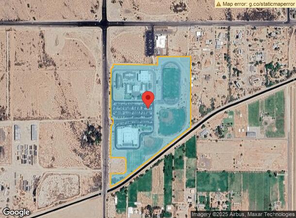
1495 S Verrado Way
Phoenix-Mesa-Scottsdale, AZ
Odyssey Institute
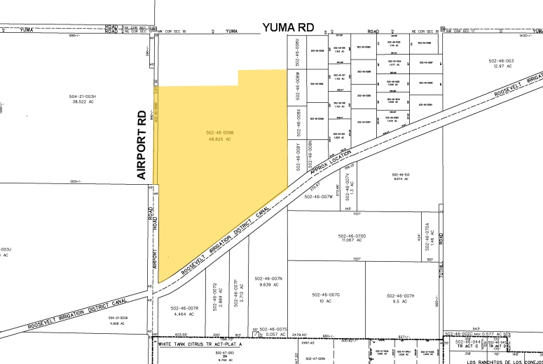
502-46-490
ODYSSEY INSTITUTE MCR 1145-37
Publicschool
Maricopa
AH
Arizona
04013C2120M
2
0
31.24 AC
2025
West I-10
050613
Phoenix
112,354 SF
DEMOGRAPHICS near 1495 S Verrado Way
1 Mile
3 Mile
5 Mile
2024 Total Population
4,307
39,799
90,194
2029 Population
4,764
44,047
99,897
Pop Growth 2024-2029
+ 10.61%
+ 10.67%
+ 10.76%
Average Age
32
35
35
2024 Total Households
1,236
11,985
27,201
HH Growth 2024-2029
+ 10.68%
+ 10.74%
+ 10.92%
Median Household Inc
$87,739
$91,481
$95,755
Avg Household Size
3.50
3.20
3.20
2024 Avg HH Vehicles
2.00
2.00
2.00
Median Home Value
$348,724
$348,928
$360,845
Median Year Built
2010
2009
2009
Nearby Places
- Restaurants
- Banks
- Shops
- Fitness
- Groceries
PUBLIC TRANSPORTATION
AIRPORT
Phoenix Sky Harbor International
DRIVE
WALK
Distance
Phoenix Sky Harbor International
44 min
33.2 mi
Freight Ports
Port of San Diego
DRIVE
WALK
Distance
Port of San Diego
369 min
330.5 mi
Nearby Properties
Address
Land Use
TOTAL SIZE
Lot Size
Zoning
Address
Land Use
TOTAL SIZE
Lot Size
Zoning
179,632 SF
16.64 AC
PR
Address
Land Use
TOTAL SIZE
Lot Size
Zoning
152,901 SF
22.52 AC
Address
Land Use
TOTAL SIZE
Lot Size
Zoning
1.98 AC
PAD
Address
Land Use
TOTAL SIZE
Lot Size
Zoning
82,692 SF
23.68 AC
Address
Land Use
TOTAL SIZE
Lot Size
Zoning
73,130 SF
3.68 AC
PAD
Address
Land Use
TOTAL SIZE
Lot Size
Zoning
12,418 SF
54.25 AC
PC
Address
Land Use
TOTAL SIZE
Lot Size
Zoning
91,505 SF
16.57 AC
PAD
Address
Land Use
TOTAL SIZE
Lot Size
Zoning
40,300 SF
19.53 AC
CC
Address
Land Use
TOTAL SIZE
Lot Size
Zoning
44,463 SF
79.72 AC
RR
Address
Land Use
TOTAL SIZE
Lot Size
Zoning
5,597 SF
164.45 AC
PR
Address
Land Use
TOTAL SIZE
Lot Size
Zoning
102,640 SF
3.73 AC
PC
Address
Land Use
TOTAL SIZE
Lot Size
Zoning
64,720 SF
2.24 AC
PC
Address
Land Use
TOTAL SIZE
Lot Size
Zoning
34,356 SF
14.43 AC
CC
Address
Land Use
TOTAL SIZE
Lot Size
Zoning
188,937 SF
20.87 AC
Address
Land Use
TOTAL SIZE
Lot Size
Zoning
65,023 SF
12.52 AC
C-C
Address
Land Use
TOTAL SIZE
Lot Size
Zoning
4,832 SF
3.66 AC
PC
Address
Land Use
TOTAL SIZE
Lot Size
Zoning
20,075 SF
4.72 AC
PC
Address
Land Use
TOTAL SIZE
Lot Size
Zoning
31,223 SF
14.39 AC
C-C
Address
Land Use
TOTAL SIZE
Lot Size
Zoning
83,200 SF
1.25 AC
PC
Address
Land Use
TOTAL SIZE
Lot Size
Zoning
14,968 SF
73.37 AC
R-43
Address
Land Use
TOTAL SIZE
Lot Size
Zoning
16.19 AC
Address
Land Use
TOTAL SIZE
Lot Size
Zoning
11.41 AC
PAD
Address
Land Use
TOTAL SIZE
Lot Size
Zoning
17,298 SF
5.58 AC
CC
Address
Land Use
TOTAL SIZE
Lot Size
Zoning
2,528 SF
17 AC
R-43
Address
Land Use
TOTAL SIZE
Lot Size
Zoning
16,558 SF
4 AC
PUD
Address
Land Use
TOTAL SIZE
Lot Size
Zoning
8,142 SF
0.98 AC
PC
The World's #1 Commercial Real Estate Marketplace
Connect with us
© 2025 CoStar Group
The information above has been obtained from sources believed reliable. While we do not doubt its accuracy we have not verified it and make no guarantee, warranty or representation about it. It is your responsibility to independently confirm its accuracy and completeness. Any projections, opinions, assumptions, or estimates used are for example only and do not represent the current or future performance of the property. The value of this transaction to you depends on tax and other factors which should be evaluated by your tax, financial, and legal advisors. You and your advisors should conduct a careful, independent investigation of the property to determine to your satisfaction the suitability of the property for your needs.