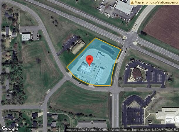
Property Record
15 20Th Ave Se, Saint Joseph, MN 56374
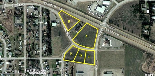
NEARBY LISTINGS FOR SALE OR LEASE
Property Detail
15 20Th Ave Se
St. Cloud, MN
K L Properties
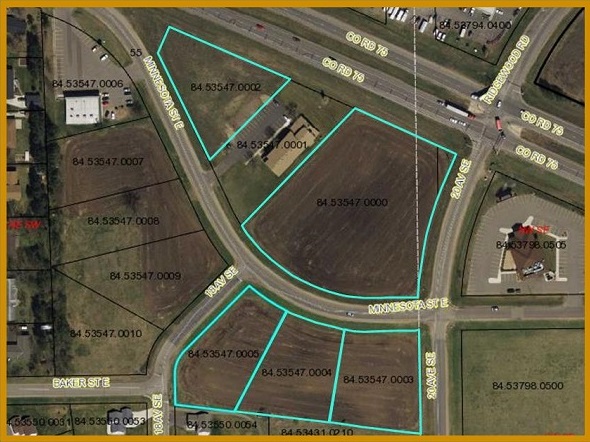
84.53547.0000
LOT 1 BLK 1 & FRL .06 AC OF NW4SE4 LYING S OF CR 75 & E OF K & L PROPERTIES ADD K & L PROPERTIES SECTION 11 TOWNSHIP 124
Medicalbuilding
Stearns
X
Minnesota
27145C0610E
1
2024
3.22 AC
2024
Stearns County
010200
Minneapolis/St Paul
10,905 SF
DEMOGRAPHICS near 15 20Th Ave Se
1 Mile
3 Mile
5 Mile
2024 Total Population
3,201
16,072
48,659
2029 Population
3,345
16,581
50,418
Pop Growth 2024-2029
+ 4.50%
+ 3.17%
+ 3.61%
Average Age
35
37
38
2024 Total Households
1,122
6,194
19,304
HH Growth 2024-2029
+ 5.08%
+ 3.37%
+ 3.76%
Median Household Inc
$68,217
$66,717
$60,517
Avg Household Size
2.30
2.30
2.40
2024 Avg HH Vehicles
2.00
2.00
2.00
Median Home Value
$192,104
$219,417
$218,498
Median Year Built
1994
1994
1993
Nearby Places
- Restaurants
- Banks
- Shops
- Fitness
- Groceries
PUBLIC TRANSPORTATION
COMMUTER RAIL
St. Cloud Amtrak Station (Empire Builder - Amtrak)
DRIVE
WALK
Distance
St. Cloud Amtrak Station (Empire Builder - Amtrak)
15 min
7.9 mi
Freight Ports
Port Milwaukee
DRIVE
WALK
Distance
Port Milwaukee
455 min
411.2 mi
SALE & LEASE HISTORY
LISTING DATE
SALE/LEASE

Sep 24, 2016
For Sale
Nearby Properties
Address
Land Use
TOTAL SIZE
Lot Size
Zoning
Address
Land Use
TOTAL SIZE
Lot Size
Zoning
52,983 SF
22 AC
Address
Land Use
TOTAL SIZE
Lot Size
Zoning
148,150 SF
143.15 AC
Address
Land Use
TOTAL SIZE
Lot Size
Zoning
113,268 SF
12 AC
PUD32
Address
Land Use
TOTAL SIZE
Lot Size
Zoning
5.34 AC
Address
Land Use
TOTAL SIZE
Lot Size
Zoning
146,285 SF
38.20 AC
Address
Land Use
TOTAL SIZE
Lot Size
Zoning
51.70 AC
PL20B2
Address
Land Use
TOTAL SIZE
Lot Size
Zoning
9,448 SF
5.10 AC
Address
Land Use
TOTAL SIZE
Lot Size
Zoning
Address
Land Use
TOTAL SIZE
Lot Size
Zoning
20,450 SF
1 AC
Address
Land Use
TOTAL SIZE
Lot Size
Zoning
3,088 SF
77.89 AC
PL20B1
Address
Land Use
TOTAL SIZE
Lot Size
Zoning
28,858 SF
1.90 AC
Address
Land Use
TOTAL SIZE
Lot Size
Zoning
33,796 SF
4.84 AC
Address
Land Use
TOTAL SIZE
Lot Size
Zoning
13,219 SF
2.19 AC
Address
Land Use
TOTAL SIZE
Lot Size
Zoning
44,631 SF
30.02 AC
Address
Land Use
TOTAL SIZE
Lot Size
Zoning
35,603 SF
24 AC
Address
Land Use
TOTAL SIZE
Lot Size
Zoning
21,528 SF
4.31 AC
R5
Address
Land Use
TOTAL SIZE
Lot Size
Zoning
84,646 SF
4.83 AC
PUD32
Address
Land Use
TOTAL SIZE
Lot Size
Zoning
84,646 SF
4.68 AC
PUD32
Address
Land Use
TOTAL SIZE
Lot Size
Zoning
97,100 SF
9.98 AC
R5
Address
Land Use
TOTAL SIZE
Lot Size
Zoning
1,675 SF
77.18 AC
2B
Address
Land Use
TOTAL SIZE
Lot Size
Zoning
4.16 AC
Address
Land Use
TOTAL SIZE
Lot Size
Zoning
Address
Land Use
TOTAL SIZE
Lot Size
Zoning
15,545 SF
50.68 AC
Address
Land Use
TOTAL SIZE
Lot Size
Zoning
76,176 SF
3.79 AC
PUD32
Address
Land Use
TOTAL SIZE
Lot Size
Zoning
58,225 SF
7.46 AC
Address
Land Use
TOTAL SIZE
Lot Size
Zoning
39,604 SF
22.58 AC
Address
Land Use
TOTAL SIZE
Lot Size
Zoning
100,010 SF
10 AC
Address
Land Use
TOTAL SIZE
Lot Size
Zoning
88,290 SF
5.02 AC
Address
Land Use
TOTAL SIZE
Lot Size
Zoning
69,151 SF
4.34 AC
PUD32
The World's #1 Commercial Real Estate Marketplace
Connect with us
© 2025 CoStar Group
The information above has been obtained from sources believed reliable. While we do not doubt its accuracy we have not verified it and make no guarantee, warranty or representation about it. It is your responsibility to independently confirm its accuracy and completeness. Any projections, opinions, assumptions, or estimates used are for example only and do not represent the current or future performance of the property. The value of this transaction to you depends on tax and other factors which should be evaluated by your tax, financial, and legal advisors. You and your advisors should conduct a careful, independent investigation of the property to determine to your satisfaction the suitability of the property for your needs.