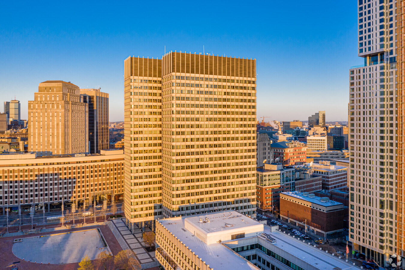
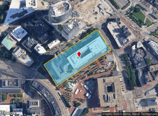
Property Record
15 New Sudbury St, Boston, MA 02203

NEARBY LISTINGS FOR SALE OR LEASE
-
-
-
-
-
-
-
-
-
-
-
-
-
-
-
-
-
-
-
-
No Photo
-
-
-
-
-
-
View all Boston listings for sale on LoopNet.com
Property Detail
15 New Sudbury St
Federalproperty
Suffolk
X
Massachusetts
25025C0081J
4.56 AC
0
North Station/Beacon Hill
2025
Boston
030302
Boston-Cambridge-Newton, MA-NH
788,776 SF
CBOS-000000-000003-002605
DEMOGRAPHICS near 15 New Sudbury St
1 Mile
3 Mile
5 Mile
2024 Total Population
64,923
425,263
938,353
2029 Population
63,179
411,881
903,030
Pop Growth 2024-2029
(2.69%)
(3.15%)
(3.76%)
Average Age
39
36
37
2024 Total Households
33,787
185,025
389,012
HH Growth 2024-2029
(2.97%)
(3.32%)
(3.92%)
Median Household Inc
$118,292
$94,406
$88,486
Avg Household Size
1.70
2.00
2.20
2024 Avg HH Vehicles
1.00
1.00
1.00
Median Home Value
$964,839
$847,373
$775,839
Median Year Built
1973
1952
1949
Nearby Places
- Restaurants
- Banks
- Shops
- Fitness
- Groceries
PUBLIC TRANSPORTATION
TRANSIT/SUBWAY
Haymarket Station (Green Line - C - Massachusetts Bay Transportation Authority Subway (The T), Green Line - E - Massachusetts Bay Transportation Authority Subway (The T), Orange Line - Massachusetts Bay Transportation Authority Subway (The T))
DRIVE
WALK
Distance
Haymarket Station (Green Line - C - Massachusetts Bay Transportation Authority Subway (The T), Green Line - E - Massachusetts Bay Transportation Authority Subway (The T), Orange Line - Massachusetts Bay Transportation Authority Subway (The T))
2 min
3 min
0.2 mi
Bowdoin Station (Blue Line - Massachusetts Bay Transportation Authority Subway (The T))
DRIVE
WALK
Distance
Bowdoin Station (Blue Line - Massachusetts Bay Transportation Authority Subway (The T))
1 min
3 min
0.2 mi
Government Center Station (Blue Line - Massachusetts Bay Transportation Authority Subway (The T), Green Line - B - Massachusetts Bay Transportation Authority Subway (The T), Green Line - C - Massachusetts Bay Transportation Authority Subway (The T), Green Line - D - Massachusetts Bay Transportation Authority Subway (The T), Green Line - E - Massachusetts Bay Transportation Authority Subway (The T))
DRIVE
WALK
Distance
Government Center Station (Blue Line - Massachusetts Bay Transportation Authority Subway (The T), Green Line - B - Massachusetts Bay Transportation Authority Subway (The T), Green Line - C - Massachusetts Bay Transportation Authority Subway (The T), Green Line - D - Massachusetts Bay Transportation Authority Subway (The T), Green Line - E - Massachusetts Bay Transportation Authority Subway (The T))
1 min
4 min
0.2 mi
North Station (Green Line - C - Massachusetts Bay Transportation Authority Subway (The T), Green Line - E - Massachusetts Bay Transportation Authority Subway (The T), Orange Line - Massachusetts Bay Transportation Authority Subway (The T))
DRIVE
WALK
Distance
North Station (Green Line - C - Massachusetts Bay Transportation Authority Subway (The T), Green Line - E - Massachusetts Bay Transportation Authority Subway (The T), Orange Line - Massachusetts Bay Transportation Authority Subway (The T))
1 min
7 min
0.4 mi
State Station (Blue Line - Massachusetts Bay Transportation Authority Subway (The T), Orange Line - Massachusetts Bay Transportation Authority Subway (The T))
DRIVE
WALK
Distance
State Station (Blue Line - Massachusetts Bay Transportation Authority Subway (The T), Orange Line - Massachusetts Bay Transportation Authority Subway (The T))
1 min
7 min
0.4 mi
COMMUTER RAIL
North Station (Fitchburg/South Acton Line - Massachusetts Bay Transportation Authority Commuter Rail (Purple Line), Haverhill Line - Massachusetts Bay Transportation Authority Commuter Rail (Purple Line), Lowell Line - Massachusetts Bay Transportation Authority Commuter Rail (Purple Line), Newburyport/Rockport Line - Massachusetts Bay Transportation Authority Commuter Rail (Purple Line))
DRIVE
WALK
Distance
North Station (Fitchburg/South Acton Line - Massachusetts Bay Transportation Authority Commuter Rail (Purple Line), Haverhill Line - Massachusetts Bay Transportation Authority Commuter Rail (Purple Line), Lowell Line - Massachusetts Bay Transportation Authority Commuter Rail (Purple Line), Newburyport/Rockport Line - Massachusetts Bay Transportation Authority Commuter Rail (Purple Line))
2 min
10 min
0.6 mi
South Station (Fairmount Line - Massachusetts Bay Transportation Authority Commuter Rail (Purple Line), Framingham/Worcester Line - Massachusetts Bay Transportation Authority Commuter Rail (Purple Line), Franklin Line - Massachusetts Bay Transportation Authority Commuter Rail (Purple Line), Greenbush Line - Massachusetts Bay Transportation Authority Commuter Rail (Purple Line), Kingston/Plymouth Line - Massachusetts Bay Transportation Authority Commuter Rail (Purple Line), Middleborough/Lakeville Line - Massachusetts Bay Transportation Authority Commuter Rail (Purple Line), Needham Line - Massachusetts Bay Transportation Authority Commuter Rail (Purple Line), Providence/Stoughton Line - Massachusetts Bay Transportation Authority Commuter Rail (Purple Line))
DRIVE
WALK
Distance
South Station (Fairmount Line - Massachusetts Bay Transportation Authority Commuter Rail (Purple Line), Framingham/Worcester Line - Massachusetts Bay Transportation Authority Commuter Rail (Purple Line), Franklin Line - Massachusetts Bay Transportation Authority Commuter Rail (Purple Line), Greenbush Line - Massachusetts Bay Transportation Authority Commuter Rail (Purple Line), Kingston/Plymouth Line - Massachusetts Bay Transportation Authority Commuter Rail (Purple Line), Middleborough/Lakeville Line - Massachusetts Bay Transportation Authority Commuter Rail (Purple Line), Needham Line - Massachusetts Bay Transportation Authority Commuter Rail (Purple Line), Providence/Stoughton Line - Massachusetts Bay Transportation Authority Commuter Rail (Purple Line))
3 min
17 min
0.9 mi
AIRPORT
General Edward Lawrence Logan International
DRIVE
WALK
Distance
General Edward Lawrence Logan International
8 min
3.4 mi
Freight Ports
Port of Boston
DRIVE
WALK
Distance
Port of Boston
8 min
2.6 mi
Nearby Properties
Address
Land Use
TOTAL SIZE
Lot Size
Zoning
Address
Land Use
TOTAL SIZE
Lot Size
Zoning
909,764 SF
25.13 AC
E
Address
Land Use
TOTAL SIZE
Lot Size
Zoning
610,560 SF
4 AC
E
Address
Land Use
TOTAL SIZE
Lot Size
Zoning
2.79 AC
Address
Land Use
TOTAL SIZE
Lot Size
Zoning
408,667 SF
3.27 AC
C
Address
Land Use
TOTAL SIZE
Lot Size
Zoning
467,952 SF
0.86 AC
BPA
Address
Land Use
TOTAL SIZE
Lot Size
Zoning
825,000 SF
5.17 AC
E
Address
Land Use
TOTAL SIZE
Lot Size
Zoning
488,832 SF
1.38 AC
BB
Address
Land Use
TOTAL SIZE
Lot Size
Zoning
142,458 SF
1.67 AC
C-3
Address
Land Use
TOTAL SIZE
Lot Size
Zoning
6.39 AC
C
Address
Land Use
TOTAL SIZE
Lot Size
Zoning
230,394 SF
0.60 AC
MXD
Address
Land Use
TOTAL SIZE
Lot Size
Zoning
596,972 SF
7.32 AC
E
Address
Land Use
TOTAL SIZE
Lot Size
Zoning
239,377 SF
0.71 AC
MXD
Address
Land Use
TOTAL SIZE
Lot Size
Zoning
334,522 SF
1.26 AC
C
Address
Land Use
TOTAL SIZE
Lot Size
Zoning
312,269 SF
0.43 AC
C
Address
Land Use
TOTAL SIZE
Lot Size
Zoning
46,259 SF
1.04 AC
E
Address
Land Use
TOTAL SIZE
Lot Size
Zoning
118,759 SF
0.92 AC
C
Address
Land Use
TOTAL SIZE
Lot Size
Zoning
377,634 SF
4.86 AC
E
Address
Land Use
TOTAL SIZE
Lot Size
Zoning
1.13 AC
C
Address
Land Use
TOTAL SIZE
Lot Size
Zoning
2.81 AC
O-2
Address
Land Use
TOTAL SIZE
Lot Size
Zoning
2.25 AC
SD-12
Address
Land Use
TOTAL SIZE
Lot Size
Zoning
3.75 AC
C
Address
Land Use
TOTAL SIZE
Lot Size
Zoning
435,381 SF
4.22 AC
LB-R
Address
Land Use
TOTAL SIZE
Lot Size
Zoning
227,107 SF
7.70 AC
E
Address
Land Use
TOTAL SIZE
Lot Size
Zoning
448,796 SF
1.84 AC
C
Address
Land Use
TOTAL SIZE
Lot Size
Zoning
237,928 SF
1.27 AC
C-3
Address
Land Use
TOTAL SIZE
Lot Size
Zoning
155,818 SF
5.33 AC
OS
Address
Land Use
TOTAL SIZE
Lot Size
Zoning
341,500 SF
1.18 AC
RC
Address
Land Use
TOTAL SIZE
Lot Size
Zoning
252,392 SF
0.52 AC
C
Address
Land Use
TOTAL SIZE
Lot Size
Zoning
325,020 SF
0.62 AC
RC
Address
Land Use
TOTAL SIZE
Lot Size
Zoning
214,398 SF
0.63 AC
BB-CSQ
The World's #1 Commercial Real Estate Marketplace
Connect with us
© 2025 CoStar Group
The information above has been obtained from sources believed reliable. While we do not doubt its accuracy we have not verified it and make no guarantee, warranty or representation about it. It is your responsibility to independently confirm its accuracy and completeness. Any projections, opinions, assumptions, or estimates used are for example only and do not represent the current or future performance of the property. The value of this transaction to you depends on tax and other factors which should be evaluated by your tax, financial, and legal advisors. You and your advisors should conduct a careful, independent investigation of the property to determine to your satisfaction the suitability of the property for your needs.