Property Record
15 W Tower Cir, Ormond Beach, FL 32174
NEARBY LISTINGS FOR SALE OR LEASE
Property Detail
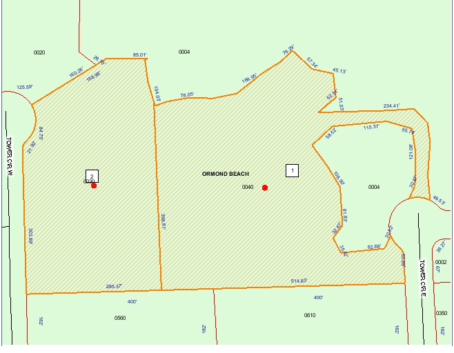
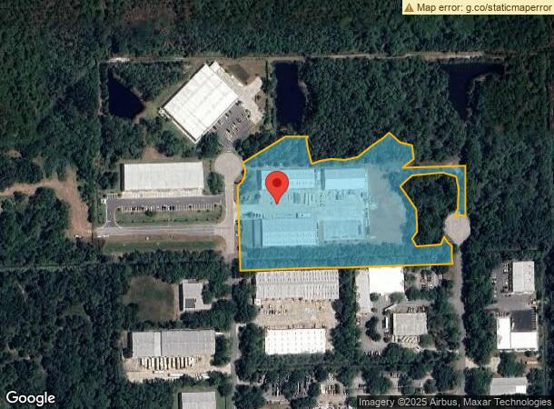
15 W Tower Cir
Deltona-Daytona Beach-Ormond Beach, FL
Airport Business Park
4138-02-00-0030
38-14-31 LOTS 3 & 4 AIRPORT BUSINESS PARK TOWER CIRCLE EXTENSION MB 54 PGS 195-197 PER OR 7019 PG 3939 PER OR 7420 PG 4973
Lightindustrial
Volusia
X
Florida
12127C0211K
3,4
2023
7.08 AC
2024
Ormond Beach
080101
Deltona/Daytona Beach
47,750 SF
DEMOGRAPHICS near 15 W Tower Cir
1 Mile
3 Mile
5 Mile
2024 Total Population
555
25,761
67,673
2029 Population
622
28,736
75,642
Pop Growth 2024-2029
+ 12.07%
+ 11.55%
+ 11.78%
Average Age
51
47
47
2024 Total Households
256
11,023
30,140
HH Growth 2024-2029
+ 12.50%
+ 11.79%
+ 12.03%
Median Household Inc
$57,806
$65,926
$59,484
Avg Household Size
2.10
2.20
2.20
2024 Avg HH Vehicles
2.00
2.00
2.00
Median Home Value
$171,666
$291,788
$269,771
Median Year Built
1997
1990
1984
Nearby Places
- Restaurants
- Banks
- Shops
- Fitness
- Groceries
PUBLIC TRANSPORTATION
AIRPORT
Daytona Beach International
DRIVE
WALK
Distance
Daytona Beach International
26 min
13.8 mi
Freight Ports
Port Canaveral
DRIVE
WALK
Distance
Port Canaveral
99 min
81.0 mi
Nearby Properties
Address
Land Use
TOTAL SIZE
Lot Size
Zoning
Address
Land Use
TOTAL SIZE
Lot Size
Zoning
12,394 SF
139.59 AC
Address
Land Use
TOTAL SIZE
Lot Size
Zoning
470,843 SF
1.78 AC
RC
Address
Land Use
TOTAL SIZE
Lot Size
Zoning
13,846 SF
126.83 AC
13T1
Address
Land Use
TOTAL SIZE
Lot Size
Zoning
180,767 SF
27.05 AC
13R6
Address
Land Use
TOTAL SIZE
Lot Size
Zoning
137,934 SF
48.30 AC
Address
Land Use
TOTAL SIZE
Lot Size
Zoning
179,868 SF
0.33 AC
Address
Land Use
TOTAL SIZE
Lot Size
Zoning
168,456 SF
15.74 AC
Address
Land Use
TOTAL SIZE
Lot Size
Zoning
768 SF
2,212.55 AC
C
Address
Land Use
TOTAL SIZE
Lot Size
Zoning
162,450 SF
1.42 AC
13B9
Address
Land Use
TOTAL SIZE
Lot Size
Zoning
5,350 SF
36.42 AC
13T1
Address
Land Use
TOTAL SIZE
Lot Size
Zoning
219,381 SF
25.44 AC
13B8
Address
Land Use
TOTAL SIZE
Lot Size
Zoning
144,576 SF
11.19 AC
13R6
Address
Land Use
TOTAL SIZE
Lot Size
Zoning
2,519.40 AC
Address
Land Use
TOTAL SIZE
Lot Size
Zoning
152,621 SF
18.26 AC
C
Address
Land Use
TOTAL SIZE
Lot Size
Zoning
161,123 SF
13.56 AC
I1
Address
Land Use
TOTAL SIZE
Lot Size
Zoning
82,156 SF
20 AC
MH4
Address
Land Use
TOTAL SIZE
Lot Size
Zoning
87,633 SF
568.96 AC
RR
Address
Land Use
TOTAL SIZE
Lot Size
Zoning
173,757 SF
11.64 AC
Address
Land Use
TOTAL SIZE
Lot Size
Zoning
156,482 SF
27.91 AC
13SE
Address
Land Use
TOTAL SIZE
Lot Size
Zoning
117,116 SF
18 AC
Address
Land Use
TOTAL SIZE
Lot Size
Zoning
180,677 SF
12.31 AC
13I1
Address
Land Use
TOTAL SIZE
Lot Size
Zoning
96,983 SF
12.79 AC
C
Address
Land Use
TOTAL SIZE
Lot Size
Zoning
255.79 AC
RPUD
Address
Land Use
TOTAL SIZE
Lot Size
Zoning
89,633 SF
9.66 AC
13R6
Address
Land Use
TOTAL SIZE
Lot Size
Zoning
56,611 SF
3.40 AC
Address
Land Use
TOTAL SIZE
Lot Size
Zoning
85,950 SF
8.24 AC
Address
Land Use
TOTAL SIZE
Lot Size
Zoning
181,481 SF
8.76 AC
13I1
Address
Land Use
TOTAL SIZE
Lot Size
Zoning
194,615 SF
11.49 AC
13B9
Address
Land Use
TOTAL SIZE
Lot Size
Zoning
24,822 SF
8.11 AC
13B1
Address
Land Use
TOTAL SIZE
Lot Size
Zoning
47,914 SF
1.93 AC
The World's #1 Commercial Real Estate Marketplace
Connect with us
© 2025 CoStar Group
The information above has been obtained from sources believed reliable. While we do not doubt its accuracy we have not verified it and make no guarantee, warranty or representation about it. It is your responsibility to independently confirm its accuracy and completeness. Any projections, opinions, assumptions, or estimates used are for example only and do not represent the current or future performance of the property. The value of this transaction to you depends on tax and other factors which should be evaluated by your tax, financial, and legal advisors. You and your advisors should conduct a careful, independent investigation of the property to determine to your satisfaction the suitability of the property for your needs.